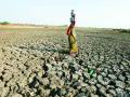
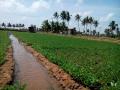
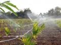
Irrigation

Analysis of surface runoff and baseflow at Tambarapani basin – A research report by National Institute of Hydrology
Posted on 24 Jul, 2010 09:12 PMThe report presents the analysis of surface runoff and baseflow carried out for the Ariyanayakipuram anicut, Tambarapani basin, Tamil Nadu for a period of 13 years (1983-95). The hydrological behavior of catchments is a very complex phenomenon and is controlled by a large number of climatic and physiographic factors that vary in time and space. The analysis shows that the contribution of baseflow at Ariyanayakipuram anicut was observed to be more.
Hydrological soil classification in Sher-Umar river doab in Narmada basin – A research report by National Institute of Hydrology
Posted on 24 Jul, 2010 05:35 PMThe report deals with hydrological soil classification in Sher-Umar river doab in Narmada basin. The study and classification of soil has in the past been undertaken by engineers and agriculturists who have confined themselves to those soil properties and materials in which they had a special interest. The soils have also been studied by geologists, but the geological description of an area does not include the information required by soil scientists. The classification designed by soil users have tended to be of limited value to others as they were designed to serve a specific and limited purpose.
Planning of crop and water management practices using weekly rainfall data - A research report by National Institute of Hydrology
Posted on 24 Jul, 2010 10:40 AMThe report presents a methodology for planning of crop and water management practices using weekly rainfall data.
Estimation of soil erosion and sediment yield in Karso catchment of Barakar basin in Jharkhand using ANSWERS model - A research report by National Institute of Hydrology
Posted on 24 Jul, 2010 10:21 AMThe report presents an estimation of soil erosion and sediment yield for the Karso catchment of Barakar basin in Jharkhand using ANSWERS model. Quantitative assessments of runoff and soil erosion are needed for proper management of land and water resources.
Study of soil moisture movement and recharge to groundwater using tritium tagging techniques in Saharanpur - A research report by National Institute of Hydrology
Posted on 24 Jul, 2010 10:05 AMThe present study aims to estimate the soil moisture movement and recharge to groundwater in Saharanpur due to monsoon rains through the unsaturated porous media in case of cultivated and uncultivated fields. Artificial radioisotope was injected at two uncultivated and five cultivated sites before the onset of monsoon and soil samples were collected from the injection points after the rainy season.
Hydrogeological and geochemical studies of groundwater flow in Suddagedda basin – A research report by National Institute of Hydrology
Posted on 24 Jul, 2010 12:18 AMThe report presents a hydrogeological and geochemical study of groundwater flow for the Suddagedda basin of Andhra Pradesh. Planning of water resources development projects calls for an understanding and analysis of the hydrological characteristics of the region. The hydrogeology and geochemistry of the basin needs to be investigated particularly for a groundwater resources development project.
Raingauge network design for Pagladiya basin - A Research Report by National Institute of Hydrology
Posted on 20 Jul, 2010 08:02 AMIn the study, raingauge network design has been developed for the Pagladiya basin of Brahmaputra river in Nalbari, Assam and Bhutan. Precipitation is the most basic data required for any water resources study and the estimation of the number & location of raingauge stations that provide adequate information regarding rainfall falling over the catchment is referred to as network design. A raingauge network is intended to serve general as well as specific purposes such as water supply, hydropower generation, flood forecasting, irrigation and flood control.
International Commission on Irrigation and Drainage invites applications for the position of its Secretary General
Posted on 19 Jul, 2010 10:42 AM
The International Commission on Irrigation and Drainage (ICID) is the leading scientific, technical, professional and not-for-profit Non-Governmental International Organisation (NGO) in the fields of irrigation and drainage. It draws together the diverse disciplines and professions involved in the planning, design, operation, management and development of irrigation, drainage and flood management works throughout the world. The Commission, with active support from a network of over 100 member countries, provides an international forum and network in which the technical, agronomic, socio-economic, environmental and managerial complexities involved in the development, management and operation of irrigation, drainage and flood control works are discussed. Improved practices are identified and promoted through the National Committees in the member countries.
A detailed description about ICID is available at www.icid.org
Crop Water Requirement for Krishnai Irrigation Project – A research report by National Institute of Hydrology
Posted on 18 Jul, 2010 11:33 AMIn this report an attempt has been made to estimate the mean monthly reference crop evapotranspiration (ETo) for the Krishnai Irrigation Project in Assam. To undertake this analysis, the mean monthly climatological and physiographical data for the period of 1986 to 1994 has been collected from the Meteorological Department, Borjhar, Assam.
A rapid geohydrological study of microwatersheds from Bolangir district, Orissa state - A report by ACWADAM
Posted on 16 Jul, 2010 03:50 PM This document by ACWADAM is a report of a rapid geohydrological assessment of some of the microwatersheds from parts of Bolangir district Orissa.
Bolangir district in Orissa forms a part of one of the hottest and backward regions of India with low land-productivity, and opportunities and technologies for agriculture in the district remain relatively unexplored.
Vagaries of rainfall and the underlying hard-rock geology further compound the problem and limit agricultural productivity to a great extent. Given such natural uncertainties, systematic implementation of a watershed management programme is the most viable avenue to overcome the problems of this region.
Bolangir district was thus selected as pilot area to conduct a pre-feasibility exercise for planning of water resources management. ACWADAM, Pune was invited, along with Samaj Pragati Sahayog, Bagli to conduct this pre-feasibility exercise.