Irrigation

Droplets: Monthly e-Newsletter (July '10)
Posted on 14 Jul, 2010 10:11 AM
Highlights
- India: World Bank Aid of USD 372 million for Coastal Zone & Water Supply
- India: Centre Approves National Mission on Micro Irrigation
- Chennai: 45 New Machines to Clear Clogged Sewers
- Stockholm Water Award 2010: Phnom Penh Water Supply Authority is the Winner
- Grundfos: World’s Largest Pump Manufacturer by VDMA List
Development of instrument for automation of irrigation scheduling and groundwater recharge monitoring using soil moisture measurement – A research report by National Institute of Hydrology
Posted on 10 Jul, 2010 06:35 PMThe report presents development of a sensor system capable of automated measurement of soil-water status, using the four-electrode resistivity (VES) method, in a soil profile. In this method, by changing the separation between two electrodes (metallic rods) placed at the ground surface without digging any holes, the variation in moisture content in the sub-surface soil profile can be monitored.
Development of data simulation model and irrigation schedules for Eastern Godavari delta (Andhra Pradesh) - A research report by National Institute of Hydrology
Posted on 28 Jun, 2010 11:45 PMThe study has been conducted to develop a data simulation model and irrigation schedules for the eastern Godavari delta irrigation system, Andhra Pradesh. It aims at analysis of various factors that influence the irrigation operations and development of appropriate mathematical models and associated computer programs.
Assessment of irrigation return flow - A research report by National Institute of Hydrology
Posted on 27 Jun, 2010 08:42 PMThis report presents the various methodologies for correct assessment of irrigation return flow, which is one of the most significant components in the water balance of irrigation command areas. A part of the water applied to the irrigation fields percolates deep to recharge the groundwater and is known as irrigation return flow. In this report methodologies have been presented for assessment of irrigation return flow through soil moisture modeling, water balance approach, experimental determination and groundwater modeling.
Changes in land use and land cover and establishment of SCS runoff Curve Number in Suddagedda basin – A research report by National Institute of Hydrology
Posted on 24 Jun, 2010 11:52 PMThe study was taken up as a part of the representative basin studies being done by NIH and involved hydrological land use & land cover mapping for the Suddagedda basin of Andhra Pradesh. Mapping was carried out through visual interpretation for the years December 1987, April 1989, December 1992 and November 1996 using IRS IB-LISS II, LANDSAT 5-TM and IRS IC-LISS III data.
Land use and land cover are the most important surface characteristics of a basin. They are very dynamic features over space and time and it is difficult to get real time information on them through conventional means. Planners need to update knowledge of natural resources, which can be obtained quickly, economically and accurately through remote sensing techniques. Further, the land use map of a basin or region provides hydrologically significant categories, which are essential for estimation of reliable runoff from ungauged basins.
Sediment yield estimation for Lower Satluj basin - A research report by National Institute of Hydrology
Posted on 23 Jun, 2010 11:43 PMThe study develops a relationship between suspended sediment load and discharge for three basins - Kasol, Suni and Lower Satluj. The sediment load (tonnes/ year) and sediment yield (tonnes/ sqkm/ year) in suspension and as bed load of sand & gravel through the river channel, reflects upland erosion in the drainage basin and deposition of sediments in the alluvial bottomlands. A good deal of the sediment eroded from upland areas is deposited on lower hills slopes, in bottomlands, lakes and reservoirs.
Bathymetric study of Mansar lake in Udhampur district - A research report by National Institute of Hydrology
Posted on 22 Jun, 2010 08:11 PMThe study undertakes an exhaustive survey of the morphometric features of the Mansar lake, Udhampur district to prepare a bathymetric map of the lake. The map is useful in understanding the lake hydrological behavior through a study of volume, sedimentation rate and identification of the high siltation zone. The study is significant as the lake water can be utilized for drinking and irrigation purposes for the water scarce Kandi belt of Jammu.
Remote sensing and GIS applications in zonation of waterlogging in command areas – A research report by the National Institute of Hydrology
Posted on 21 Jun, 2010 04:48 PMThe study assesses waterlogging in a canal command area in Rohtak and Jhajjhar districts through waterlogging area zonation using multi-spectral and multi-temporal imagery like IRS LISS III data of pre and post monsoon period. Seasonal and permanent waterlogged area and standing water were delineated on the basis of remote sensing data, digital elevation model and groundwater data.
Groundwater quality in adjoining areas of River Yamuna at Delhi - A research report by National Institute of Hydrology
Posted on 21 Jun, 2010 04:41 PMThe study assesses the suitability of groundwater for drinking and irrigation use and examines the likely impact of Yamuna river water quality on groundwater. Delhi is faced with severe problems associated with groundwater quality and quantity. The quality varies spatially and seasonally, with depth and is primarily governed by the extent and composition of dissolved solids present in it. Surface water bodies play a role and the hydraulic gradient determines the lateral and vertical migration in the groundwater flow system.
Groundwater samples were collected through extensive field surveys covering entire Delhi area representing various geo-hydrological and land-use conditions. The data has been analysed with respect to BIS and WHO standards to examine its suitability for various uses. The area has a peculiar feature of infiltration of surface water to groundwater from river Yamuna and from various drains.
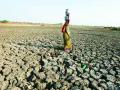
Need to bring focus of water & agriculture policies onto rainfed farming : SANDRP May '10
Posted on 18 Jun, 2010 11:03 AM![]()
The Dams, Rivers and People issue for Apr-May 2010 is out. The state government policies, programmes and practices in water resources and highlights the need to bring focus of water & agriculture policies onto rainfed Farming. It is likely to yeild better economic, hydrologic, sustainable, equitable and climate friendly results and foodgrains production as per our future demands.