Ganga
River basin planning for Ganga : Lessons from Murray-Darling Basin Authority
Posted on 02 Feb, 2012 09:15 PMThis interactive session with NGOs working on water and river issues was held in continuation of the “Living rivers, dying rivers” series at the request of AusAid. The meeting was chaired by Prof. Ramaswamy R. Iyer, Honorary Professor, Centre for Policy Research and an author of books and articles on water while the lead speaker Dr.
Interdisciplinary approach to water management: From the uplands to the coast - The Ganges-Brahmaputra-Meghna Basin
Posted on 30 Dec, 2011 11:04 AMIn this paper, Jayanta Bandopadhyay explains the need for an interdiscipliinary framework for water resource management. He states that this framework needs to include ecological, social, economic and institutional perspectives. These perspectives are essential to facilitate cooperation over the management of transboundary rivers.

The impacts of water infrastructure and climate change on the hydrology of the Upper Ganges river basin – A research report by IWMI
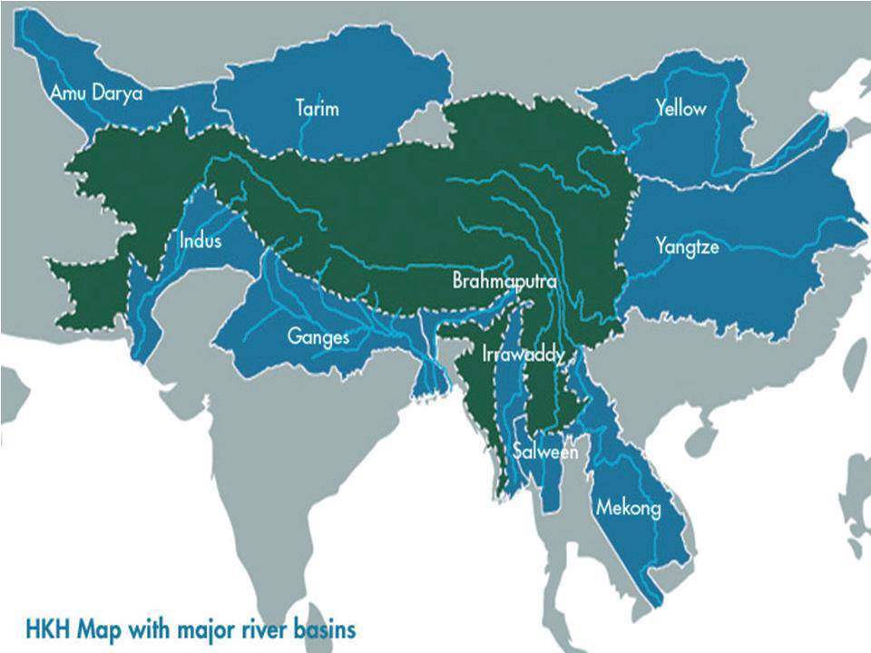
Posted on 18 Dec, 2011 07:03 PM The Ganges river system originates in the Central Himalayas, and extends into the alluvial Gangetic Plains and drains into the Indian Ocean at the Bay of Bengal. In the upstream mountainous regions, hydropower is the main focus of development with mega and micro projects either under construction or being planned in both Nepal and India.
After the main river channel reaches the plains, it is highly regulated with dams, barrages and associated irrigation canals. All this infrastructure development and abstractions affects the river’s flow regime and reduces flows, which, in turn, impacts downstream water availability, water quality and riverine ecosystems. Furthermore, there are concerns that climate change is likely to exacerbate the water scarcity problem in the Ganges Basin. Therefore, modeling the hydrology of the basin is critical for estimation, planning and management of current and future water resources.
Qualitative and quantitative water scarcity issues in Bihar - A presentation
Posted on 21 Nov, 2011 11:49 AMThis presentation highlights the grave water situation in Bihar in the context of the emerging water quality and quantity issues that the world and especially developing countries will be facing in the near future.
National Conference on River Ganga Basin Management: Issues and Challenges, Centre for Environmental Science and Technology, BHU, January 9-11, 2012, Varanasi
Posted on 18 Oct, 2011 12:26 PMOrganizer: Centre for Environmental Science and Technology
Venue: Banaras Hindu University, Varanasi

WWF invites applications for Senior Programme Officer – Coordinator, Delhi - Apply by October 10, 2011
Posted on 06 Oct, 2011 07:41 PMContent courtesy – DevNetJobsIndia

WWF-India has been working to promote harmony between human beings and nature for more than four decades.
Hydrology of the Upper Ganga river – A report by the International Water Management Institute
Posted on 21 Aug, 2011 10:43 PMTo provide the background hydrological information for the assessment of environmental flow requirements at four selected ‘Environmental Flow’ sites, a hydrological model was set up to simulate the catchment in the present state (with water regulation infrastructure) and to generate the natural flows (without water regulation infrastructure).
Water quality status of rivers in India – Report of Central Water Commission
Posted on 15 Jul, 2011 06:19 PMThe Level-I Laboratories are located at 258 field water quality monitoring stations on various rivers of India where physical parameters such as temperature, colour, odour, specific conductivity, total dissolved solids, pH and dissolved oxygen of river water are observed.
Analysing the role of geomorphic features in Kosi flood – An article in Geospatial World
Posted on 12 Jul, 2011 10:45 AMKosi is known as the sorrow of Bihar due to its frequent and often disastrous floods. The major geomorphic units of flood-inundated area in Kosi fan (terrain of Kosi river in India) are sand bars in the form of inter-connected drainage networks, an ox-bow lake and its meandering cut-off and imprint.