Rainfall and other forms of Precipitation


Press Release : Water Initiatives Orissa
Posted on 05 Jun, 2009 12:15 AMGuest Post by: Ranjan Panda
Sambalpur 27.5.2009
What 'Water Initiatives Orissa (WIO)' had found out three years ago have been substantiated now by a World Bank report, titled 'Climate Change Impacts in Drought and Flood Affected Areas: Case Studies in India'. The World Bank report , which took Orissa as a case study of flooding in a climate change scenarios - has referred to projections that 'temperatures, precipitation, and flooding are likely to increase, with adverse impacts on crop yields and farm incomes. Among the more substantial effects is a spatial shift in the pattern of rainfall towards the already flood-prone coastal areas'. Three years ago the WIO had found out significant increase in average annual rainfall in coastal districts like Baleswar and Puri. Now the World Bank report has projected 23 per cent increase in annual mean rainfall in that region.
Rainfall data sources for Karnataka
Posted on 02 Jun, 2009 10:25 AMIndia water portal has a meteorological data application that has climate parameters on a .5 by .5 latitude/longitude grid throughout the country, for a 100 years. The data is derived from a research data set from the Tyndall Center for Climate Change Research in the UK.
Regional meeting - "Mazhapolima", Thrissur
Posted on 02 Jun, 2009 09:22 AMForwarded to the Portal by: Nitya Jacob, UN ![]()
Dr Kurien Baby, District Collector of Trissur, Kerala, and Solution Exchange Water Community are organizing a regional meeting to discuss the effects of the Mazhapolima program. The dates are 16-17 June 2009, and it will be held in Trissur.
Background
Kerala has among the highest well densities in India, and 71% of the population depends on them for drinking water. The aggregate household investment in the state on wells is pegged at Rs 1800 crore and they have a combined yield potential of 6.6 million cu m per day. That works out to a water availability of 197 litres of water per capita per day (lpcd), well above the government's prescribed norm of 140 lpcd. These wells are threatened. Despite an annual rainfall of 3,000 mm, 70% go dry in summer. The surface runoff is heavy, and therefore groundwater levels in several blocks have fallen sharply, and coupled with saline intrusion at an accelerated pace, have led to water quality problems.
Various sources for rainfall, temperature and climate data of India and World
Posted on 01 Jun, 2009 05:36 PMRainfall and temperature "normals" for 110 major cities from Indian meteorological department
This "important cities" link gives monthly mean maximum and minimum temperature and monthly total rainfall of important stations for the period 1901-2000 for 110 major cities and towns of India.
Effect of climate change on water resources - a preliminary consolidated report by Central Water Commission and the National Institute of Hydrology
Posted on 28 May, 2009 01:12 PM This report on the Effect of Climate Change on Water Resources, prepared by the Central Water Commission and the National Institute of Hydrology, under the guidance of the Ministry of Water Resources in 2008, is one of the first official reports made available by the Government of India, of a reliable quantitative assessment based on field data, of the likely effect of climate change on the availability of water resources, i.e. on the glaciers and snow melt, on rainfall and their effect on run off into the river system and their contribution to ground water.
NASA Earth Observatory: Cyclone Bijli
Posted on 07 May, 2009 12:03 PMImage & Content Courtesy: NASA Earth Observatory
 A ragged-looking Tropical Storm Bijli draped the east coast of India in this image from the Moderate Resolution Imaging Spectroradiometer (MODIS) on NASA's Terra satellite on April 16, 2009. Bijli became a tropical storm in the northwest Bay of Bengal on April 15, and initially headed north, toward the west coast of India. By April 16, it had begun a northeastward turn, however, and the storm was being projected to make landfall in eastern Bangladesh on April 17, according to Unisys. Access higher resolution image here:Cyclone Bijli
The Sambalpur declaration on Odisha rivers : Let the river flow
Posted on 23 Apr, 2009 12:04 PMWater Initiatives Orissa(WIO) and the Indian River Network (IRN) organsied the Odisha River Conference during 18 - 20 April 2009 at Sambalpur, Odisha. Attended by about 75 participants which included activists, environmentalists, journalists, academicians, researchers and civil society representatives from across the country, the Conference has just concluded with a "Sambalpur Declaration" that calls for saving the rivers from the current fate of high rate of degradation and giving communities their traditional rights over the rivers, among other strong resolutions.
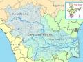
Cauvery basin: its culture, places of historical significance, birth place, climate, precipitation, catchment, tributaries, state-wise spread, landuse
Posted on 14 Apr, 2009 12:21 PMCulture and places of historical significance
The river Cauvery has been the inspiration for various civilizations who have thrived on the banks of the river. This can be seen manifested in the various forms of art, culture and philosophy that have originated along the course of the river.
Kosi Katha - The making of a famine': Video highlighting the growing famine in the wake of the floods in Bihar
Posted on 14 Apr, 2009 04:05 AM
The latest loss figures (24 Feb. 09 is five districts, 35 blocks, 33.29 lakh peopla, 9.97 lakh live stock., affected area 3.68 lakh hectares, 2.37 lakh houses, 527 human death a and 19,323 loss of cattle.
Kosi darshan: A deeper look at the lives of those pinned on the river
Posted on 31 Mar, 2009 05:14 PM"If it had not breached at Kusaha, it would have anyway breached at this point," points a villager towards the probable location on the eastern bank in village Rajabaas near Prakashpur in Sunsari district of Nepal, located 14 km upstream of Kusaha where the Eastern Afflux embankment of the Kosi had breached on the August 18, 2008.