India
Wastelands Atlas of India by National Remote Sensing Centre and Ministry of Rural Development (2010)
Posted on 08 Nov, 2010 10:46 PMThis report presents the latest Wastelands Atlas, put together by the Ministry of Rural Development (MoRD) and National Remote Sensing Centre (NRSC) developed as a part of the “National Wasteland Monitoring Project”. The mapping efforts have generated valuable datasets on unutilized/vacant lands and their use in watershed and wastelands management.
The three sets of Wastelands Atlas of India by NRSC comprise -
Conducted open source GIS training for United Nations Population Fund
Posted on 08 Nov, 2010 08:37 PMTwo Weeks Customized training program on Quantum GIS and GRASS GIS for Census Department was conducted by United Nations Population Fund Office(UNFPA), Koreain Collaboration with Magendhiran Consultancy Services from 18th - 29th Oct 2010.
Open courseware of national programme on technology enhanced learning A summary of civil engineering courses
Posted on 06 Nov, 2010 07:59 AMThe India Water Portal is pleased to announce to its users, that the Civil Engineering courses from the multi-faceted and multi-modal open courseware of National Programme on Technology Enhanced Learning (NPTEL) have been put together in the form of a summary. These courses are being carried out by Indian Institutes of Technology and the Indian Institute of Science Bangalore as a collaborative project supported by the Ministry of Human Resource Development (Government of India) to enhance the quality of engineering education in the country, by developing curriculum based video and web courses. In these web based lectures, the authors have developed the subject in detail and in stages in a student-friendly manner.
A training manual on integrated management of watersheds by ICRISAT
Posted on 05 Nov, 2010 12:05 PMThe training manual by ICRISAT on integrated management of watersheds is meant for watershed development practitioners and provides an account of the socio-technical aspects of watershed. To begin with, the definitional aspects of watershed are spelt out -
- The term “watershed” strictly refers to the divide separating one drainage basin from another. However, over the years, the use of the term watershed to signify a drainage basin or catchment area has come to stay.
- Hydrologically, watershed could be defined as an area from which the runoff drains through a particular point in the drainage system.
Gully control in semi arid tropical watersheds – A report by ICRISAT
Posted on 04 Nov, 2010 09:21 PMThis report prepared by ICRISAT under its Global Theme on Agroecosystems deals with the problem of gully erosion, which is common in the semi-arid region, characterized by denuded landscape and flash floods. An estimated 4 million ha land in India and 29 million ha of land in Africa are affected by severe gully erosion. Gully erosion is more difficult and expensive to control than other types of soil erosion.
The Indian Summer Monsoon - Past, Present and Future - A presentation
Posted on 03 Nov, 2010 02:56 PMThe history of the United Kingdom’s interest in the Indian monsoon is discussed as also the challenges of climate change for India. Some basic facts regarding the Indian socio-economic context are presented to underline the importance of rainfed agriculture and hence the dependence on monsoons.
NABARD Consultancy Services is looking for Consultants at Watershed Projects
Posted on 03 Nov, 2010 02:09 PMContent and Image Courtesy: NABARD Consultancy Services
NABCONS is providing consultancy services to NABARD for implementing watershed projects in Rajasthan, Gujarat and Andhra Pradesh. The operational responsibility of the programme implementation rests with the Programme Management Unit (PMU), established especially for implementing the projects at Dahod (Gujarat), Udaipur (Rajasthan), Warangal, Sangareddy and Ongole (Andhra Pradesh).
News roundup (22 - 31 October 2010) :" India: Land of many cell phones, but fewer toilets"
Posted on 03 Nov, 2010 08:50 AMWastewater/Sanitation
Water Jobs via DevNetJobsIndia.org dated October 27, 2010
Posted on 27 Oct, 2010 01:37 PMContent Courtesy: DevNetJobsIndia
- Short Term Assignment - Social Researcher / Documentation Specialist
Water Sanitation and Hygiene (WASH) Institute
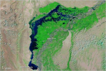
A blue Pakistan, submerged, in NASA image
Posted on 27 Oct, 2010 11:09 AMNew satellite images from NASA show the extraordinary scope of the continuing disaster in Pakistan, where thousands of square miles of land remain submerged two months after the country was hit by catastrophic flooding.
 A satellite image captured last week shows flood waters lingering in Sindh Province and Manchhar Lake at twice its normal size.