Surface Water
The Andhra Pradesh drainage cess act - The Andhra Pradesh Gazette (1985)
Posted on 12 Oct, 2010 11:59 AMThe document goes on to give the details of the implementation of the Act and includes:
Guidelines for repair, renovation and restoration of water bodies with external assistance and domestic support - Ministry of Water Resources (2009)
Posted on 11 Oct, 2010 02:57 PMThese two documents by the Government of India, Ministry of Water Resources (MoWR) provide information and details on the 'Repair, Renovation and Restoration (RRR) of Water Bodies' scheme that has been launched by the Ministry under the state sector, one with domestic budgetary support and the other with external assistance.
Indian farmers fight billionaire Mittal and Posco, a leading company in steel making, for water rights in Orissa : News roundup (1-7 October 2010)
Posted on 08 Oct, 2010 10:24 AMWater for Industry
Drinking Water/Urban Water/Water Quality
- The Bangalore Water Supply and Sewerage Board (BWSSB) loses money on half of water it supplies
- The Brihanmumbai Municipal Corporation (BMC) is paying a hefty price for supplying water to Mumbai with outstanding water supply dues upto Rs 3,065 crore
- 40% water is lost in leakages in Mumbai: The water level over the catchment area at 12.9 lakh ml, but the city still wrangling with water woes
- Poor access to safe and good quality drinking water: water contamination is an important public health concern in Bihar
- After several years of suffering, the villagers of Hebani Gram Panchayat in Mulbagal Taluk of Kolar have found a way to get safe drinking water by themselves
- 1650 water supply schemes planned for meeting the drinking water needs of people in rural areas in Madhya Pradesh
- Diarrhoea cases on the rise in Orissa
- Cholera incidence second highest in Kolkata
National Water Academy training programmes now open to Indian citizens
Posted on 04 Oct, 2010 03:13 PM

National Water Academy (NWA) is a training institution of the Ministry of Water Resources, Government of India. NWA conducts training programs that cover all aspects of water resources development and management at basin scale, viz. hydrology, hydrometry and telemetry; flood management; investigation, planning and formulation of river valley projects; environmental and social aspects of river valley projects; design of dams /barrages /canals /gates/ hydro-power structures and FEM; dam safety and instrumentation; GIS and Remote Sensing; Hydro-informatics; IWRM; Water Policy; etc.
Water Resources Engineering and Management - A Civil Engineering Course under the National Programme on Technology Enhanced Learning
Posted on 29 Sep, 2010 07:42 AMThis Civil Engineering Course under the National Programme on Technology Enhanced Learning (NPTEL) on the broad subject of Water Resources Engineering and Management is being carried out by Indian Institute of Technology’s and the Indian Institute of Science, Bangalore as a collaborative project supported by the Ministry of Human Resource Development (Government of India) to enhance the quality of engineering education in the country, by developing curriculum based video and web courses. In these web based lectures, the authors have developed the subject in detail and in stages in a student-friendly manner. The broad group of Water Resources Engineering is structured into modules on the topic by IIT Kharagpur as follows:
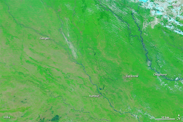
Flooding in Northern India: Updates from Earth Observatory
Posted on 28 Sep, 2010 02:16 PMHeavy monsoon rains had pushed the Ganges and other rivers over their banks by late September 2010. The flooding left at least 2 million people homeless in northern India, Reuters reported. Some 500,000 hectares (1.25 million acres) of agricultural land were also flooded. Authorities reported that the Ganges and its tributaries had risen to near record levels, and meteorologists forecast more rains in the days ahead.

Earth sciences in watershed management – A presentation by ACWADAM
Posted on 23 Sep, 2010 08:04 AMThis presentation by ACWADAM on earth sciences in watershed management shows how the occurrence of water within a watershed is governed by the rock types occurring both at the surface and within the subsurface, their sequence and their structure. The presentation deals with the basic components involved in the mapping of a watershed –
- The type of rocks (lithology), and
- The structure (whether these are folded, faulted, fractured, jointed etc.,)
An Invitation to rally in the valley - 25 years of Struggle and Reconstruction in Narmada Valley, Badwani, Madhya Pradesh
Posted on 21 Sep, 2010 05:01 PMForwarded to the Portal by: National Alliance of People's Movements (NAPM)
Geological mapping – A presentation by ACWADAM
Posted on 21 Sep, 2010 08:27 AMThis presentation by ACWADAM deals with geological mapping. The occurrence of water within a watershed is governed by the rock types occurring both at the surface and within the subsurface, their sequence and their structure. The physical structure which plays host to the water within the watershed is geological. Every watershed programme must therefore include a fundamental understanding of this framework so that the development and management measures planned through such programmes are meaningful and properly justified technically.
Save agriculture in Narmada valley
Posted on 20 Sep, 2010 04:44 PMNarmada valley is facing yet another crisis beyond the gigantic dams, which has arisen due to the huge canal network of the Indira Sagar and Omkareshwar canals. The canals of these two dams are not yet fully planned, yet certain estimates, which are not yet final by the Narmada Valley Development Authority show that not less than 10,000 hectares of agricultural land is to be acquired, but a larger acquisition is yet to come up in numerous villages, where even a basic socio-economic survey of the affected land and families is yet to be undertaken.


