Rivers

Featured Articles
November 25, 2022 These maps at the watershed scales have been made to not only ensure inclusion of different freshwater ecosystems, their connectivity and hydrological processes, but can also provide a spatial context for conservation decisions.
A stream at Anini, Arunachal Pradesh (Image Source: Roshni Arora)
October 30, 2022 This book by Dr. Mitul Baruah presents a fascinating, ethnographic account of the challenges faced by communities living in Majuli, India, one of the largest river islands in the world, which has experienced immense socio-environmental transformations over the years, processes that are emblematic of the Brahmaputra Valley as a whole. This is an excerpt from the book.
Floods are recurrent phenomena in Assam (Image: Mitul Baruah)
October 11, 2022 In an effort to inform the general public, especially citizen activists, policymakers, researchers, and students, about the current status of the Vrishabhavathi river, Paani.Earth has created the necessary maps, data, analysis, and information to drive conservation awareness and action around the river.
Vrishabhavathi river (Image Source: Paani.Earth)
October 6, 2022 Rapid urbanisation and faulty land use policies are rapidly destroying forests, grasslands and wetlands in Jammu and Kashmir, India and the ecosystem value services they provide. Can these valuable ecosystems be saved?
Deteriorating ecosystems of Jammu and Kashmir, India (Image Source: tkohli at Flickr via Wikimedia Commons)
September 5, 2022 In an attempt to present a perspective on how rivers are used and abused, a map of the Bengaluru rivers illustrate how waste flows through natural river corridors, polluting the rivers and altering their status.
Vrishabhavathi river flow at Thagachguppe Bridge, Kumbalgodu (Image Source: Paani.Earth)
August 11, 2022 This could lead to water quality crisis reinforcing the need for basin-specific management strategies
Around the world, more than a fifth of nitrogen released by human activity ends up in aquatic ecosystems (Image: Wikimedia Commons)
Scarcity amidst plenty: Kerala's drinking water paradox
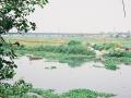
Kerala is blessed with high rainfall as well as plenty of natural water sources, but it has the lowest per capita share of freshwater resources in the country. Posted on 14 Nov, 2015 02:48 PM

Kerala, flanked on the west by the Arabian Sea and on the east by the Western Ghats is bestowed with enviable natural resources. It has 44 rivers spanning its lush green landscape and rainfall that averages as high as 3000 mm a year.

The Karamana river in Thiruvanathapuram, Kerala (Source: India Water Portal)
Wildlife Board panel not to consider projects in and around protected areas
Policy matters this week Posted on 11 Nov, 2015 08:23 PM

Panel not to consider projects until eco-zones are clearly demarcated

Sariska Tiger Reserve, Rajasthan (Source: Vasundhara Deogawanka via IWP Flickr Photos)
State Government's slow response caused 2013 flash floods: CAG
News this week Posted on 11 Nov, 2015 08:19 PM

CAG report blames Uttarakhand Government for 2013 flash floods

House washed away by the Uttarakhand floods (Source: IWP Flickr Photo)
Mansarovar or Gaumukh: Which is the source of the Ganga?
News this week Posted on 03 Nov, 2015 12:11 PM

NIH scientists to probe if Mansarovar is the source of Ganga

Bhagirathi river at its source, Gaumukh (Source: IWP Flickr Photo)
20 sq.km forest area to be diverted for “blue and green, environment-friendly capital city” Amaravati
Policy matters this week Posted on 03 Nov, 2015 12:00 PM

Centre to allow diversion of a whooping 20 sq.km. forest area for Andhra's new capital

An undisturbed forest (Source: IWP Flickr Photo)
Adapting to floods and improving lifestyles could give us some clues to finding an alternative to embankments
Dr David Molden, Director General, ICIMOD, talks to Monoj Gogoi on his visit to flood-affected Lakhimpur and Dhemaji districts of Assam and Itanagar, Arunachal Pradesh. Posted on 29 Oct, 2015 01:46 PM

Dr Molden, you have visited Dihiri in Dhemaji district and Borsala in Lakhimpur districts. Both these villages are the worst flood affected villages of the region. You also interacted with the communities in these two villages. What was the purpose of this visit? Please share your experiences.

In conversation with Dr Molden (Source: Monoj Gogoi)
UNESCO Workshop on 'Ensuring Water Security in Changing Environment Scenario for Water Professionals of Cluster Countries'
A 2-day regional capacity development workshop Water Professionals of South Asian Countries’ sponsored by UNESCO is being organized jointly by IIT Bombay.
Posted on 27 Oct, 2015 10:44 AM

A regional capacity development workshop on ‘Ensuring Water Security in Changing Environment Scenario for Water Professionals of South Asian Countries’ sponsored by UNESCO is being organized jointly by IIT Bombay, NIH Bho

Environment Ministry to review Critically Polluted Areas
Policy matters this week Posted on 26 Oct, 2015 09:57 PM

Environment Ministry gets strict towards the compliance of green norms

CSEB power plant in Korba (Source: IWP Flickr Photo)
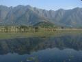
Srinagar's Dal Lake shrinks by 36% in the last 37 years
News this week Posted on 26 Oct, 2015 09:43 PM

Study shows half of Srinagar's water bodies have disappeared in the past century

Dal Lake in Srinagar (Source: McKay Savage via Wikipedia)
How much water should flow in the Yamuna?
Considered sacred, the Yamuna is gasping for breath today choking on the unprecedented load of sewage and industrial effluents that drain into it. Can its ecological flow be worked out? Posted on 26 Oct, 2015 05:17 PM

Rivers are the not just the lifeline of our country, but life itself. We may revere them, even worship them but we continue to pollute, choke, and poison their waters. A river, its catchment area, and its floodplains have evolved over millions of years, and once damaged, may not be easy to reclaim.

For a river to be healthy & maintain all its associated functions, free flow must be close to 50-60% of the total flow all year round (Source: Wikimedia)
×