Rivers

Featured Articles
November 25, 2022 These maps at the watershed scales have been made to not only ensure inclusion of different freshwater ecosystems, their connectivity and hydrological processes, but can also provide a spatial context for conservation decisions.
A stream at Anini, Arunachal Pradesh (Image Source: Roshni Arora)
October 30, 2022 This book by Dr. Mitul Baruah presents a fascinating, ethnographic account of the challenges faced by communities living in Majuli, India, one of the largest river islands in the world, which has experienced immense socio-environmental transformations over the years, processes that are emblematic of the Brahmaputra Valley as a whole. This is an excerpt from the book.
Floods are recurrent phenomena in Assam (Image: Mitul Baruah)
October 11, 2022 In an effort to inform the general public, especially citizen activists, policymakers, researchers, and students, about the current status of the Vrishabhavathi river, Paani.Earth has created the necessary maps, data, analysis, and information to drive conservation awareness and action around the river.
Vrishabhavathi river (Image Source: Paani.Earth)
October 6, 2022 Rapid urbanisation and faulty land use policies are rapidly destroying forests, grasslands and wetlands in Jammu and Kashmir, India and the ecosystem value services they provide. Can these valuable ecosystems be saved?
Deteriorating ecosystems of Jammu and Kashmir, India (Image Source: tkohli at Flickr via Wikimedia Commons)
September 5, 2022 In an attempt to present a perspective on how rivers are used and abused, a map of the Bengaluru rivers illustrate how waste flows through natural river corridors, polluting the rivers and altering their status.
Vrishabhavathi river flow at Thagachguppe Bridge, Kumbalgodu (Image Source: Paani.Earth)
August 11, 2022 This could lead to water quality crisis reinforcing the need for basin-specific management strategies
Around the world, more than a fifth of nitrogen released by human activity ends up in aquatic ecosystems (Image: Wikimedia Commons)
Ken-Betwa river link project hits a roadblock
Policy matters this week Posted on 23 Feb, 2016 12:09 PM

No clearance to Ken-Betwa river link project till wildlife issues are addressed

Map showing Ken-Betwa river link (Source: Shannon via Wikipedia)
Art of killing a river
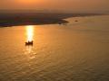
Manoj Misra speaks on the much neglected area of the Yamuna river and its floodplains and why its mere clean-up is not enough--especially as the World Culture Festival approaches. Posted on 22 Feb, 2016 01:19 PM

Recent permission granted to the Art of Living to hold the World Culture Festival in the Yamuna floodplains points fingers yet again at the fact that not much has been done to assure its safety. The rapid encroachment of the Yamuna floodplain has raised a few questions. Can the river sustain the rampant commercialisation of its floodplains?

NGT had in July 2015 slapped a fine on the Akshardham temple management for carrying out expansion without prior environmental clearance and without examining whether the expanded portion fell on the Yamuna’s floodplains (Source: Ramesh N G, Wikimedia Commons)
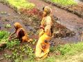
Floating gardens for the landless
Flood affected areas in coastal Odisha have adopted new ways of farming. Called floating gardens, these have the scope to reduce the food insecurities of the landless poor. Posted on 17 Feb, 2016 09:49 PM

The coastal district of Puri in Odisha is infested with water hyacinth. In 1982, 10 million people and 3 million hectares of agricultural land was affected by floods causing the water hyacinth to increase to such an extent that it has affected the lives and livelihood of communities for almost three decades.

Women working on a floating garden (Source: RCDC)
Saved by tanks: The story of Puducherry’s Bahour commune
While the monster floods of 2015 mercilessly gobbled up villages along the coast of Tamil Nadu, settlements in neighbouring Puducherry managed to escape the fury. Miracle, you say? Posted on 16 Feb, 2016 10:13 AM

The East Coast of India is very much unlike its western counterpart both in terms of physiography and climatology.

The Manapet tank in Bahour has an ayacut of around 110 acres, most of which is now urbanised (Image: Seetha Gopalakrishnan, IWP)
Environmentalists protest proposed projects near Konkan coastline
News this week Posted on 09 Feb, 2016 12:48 PM

Activists stand against three proposed projects near Konkan coastline

A thermal power plant in Ennore, Chennai (Source: India Water Portal Flickr Photos)
Eight ministries now responsible for Ganga clean up
Policy matters this week Posted on 09 Feb, 2016 12:39 PM

Seven ministries other than the Water Ministry to help revive the Ganga

Ganga at Gadmukteshwar (Source: India Water Portal Flickr Photos)
Government sets ambitious targets for MGNREGS
Policy matters this week Posted on 26 Jan, 2016 02:09 PM

Aiming for an outcome-oriented programme, Government sets ambitious targets for MGNREGS

Labourers building check dams under MGNREGS (Source: IWP Flickr Photos)
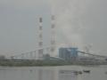
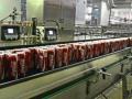
UP Coca Cola plant in trouble again
News this week Posted on 26 Jan, 2016 02:03 PM

CPCB finds Coca Cola plant in Hapur pumping toxic water into a pond

Coca Cola bottling plant (Source: S. Subramanium via Hindu)
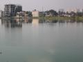
11,000 acres lake land encroached in Bengaluru
News this week Posted on 19 Jan, 2016 11:29 AM

Panel finds Bengaluru Development Authority (BDA) and private builders responsible for 11,000 acres of lake land encroachment

Rachenahalli Lake in Bengaluru (Source: Sumetee Pahwa Gajjar)
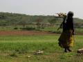
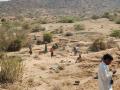
The semi-arid regions of the Moyar-Bhavani basin
State sponsored policies and programmes must be sensitive to promote sustainable developmental activities in this already fragile social ecological system in Tamil Nadu. Posted on 17 Jan, 2016 10:56 PM

Today's rural poor operate in highly risky and uncertain environments. Grappling with multiple stresses like eroding natural resources, poor assets and increasing climate variability, they are constantly adjusting their lives and livelihoods--changing a crop grown, digging another well, or migrating to a nearby town.

Large population of scheduled caste, and other communities reside in or around protected areas of the basin.
×