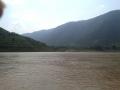
Rivers

Featured Articles
November 25, 2022 These maps at the watershed scales have been made to not only ensure inclusion of different freshwater ecosystems, their connectivity and hydrological processes, but can also provide a spatial context for conservation decisions.
A stream at Anini, Arunachal Pradesh (Image Source: Roshni Arora)
October 30, 2022 This book by Dr. Mitul Baruah presents a fascinating, ethnographic account of the challenges faced by communities living in Majuli, India, one of the largest river islands in the world, which has experienced immense socio-environmental transformations over the years, processes that are emblematic of the Brahmaputra Valley as a whole. This is an excerpt from the book.
Floods are recurrent phenomena in Assam (Image: Mitul Baruah)
October 11, 2022 In an effort to inform the general public, especially citizen activists, policymakers, researchers, and students, about the current status of the Vrishabhavathi river, Paani.Earth has created the necessary maps, data, analysis, and information to drive conservation awareness and action around the river.
Vrishabhavathi river (Image Source: Paani.Earth)
October 6, 2022 Rapid urbanisation and faulty land use policies are rapidly destroying forests, grasslands and wetlands in Jammu and Kashmir, India and the ecosystem value services they provide. Can these valuable ecosystems be saved?
Deteriorating ecosystems of Jammu and Kashmir, India (Image Source: tkohli at Flickr via Wikimedia Commons)
September 5, 2022 In an attempt to present a perspective on how rivers are used and abused, a map of the Bengaluru rivers illustrate how waste flows through natural river corridors, polluting the rivers and altering their status.
Vrishabhavathi river flow at Thagachguppe Bridge, Kumbalgodu (Image Source: Paani.Earth)
August 11, 2022 This could lead to water quality crisis reinforcing the need for basin-specific management strategies
Around the world, more than a fifth of nitrogen released by human activity ends up in aquatic ecosystems (Image: Wikimedia Commons)
Centre approves 50 more days of work under MGNREGA to tackle drought
Policy matters this week Posted on 21 Sep, 2015 10:14 PM

50 more days of work under MGNREGA in drought-hit areas

Labourers building check dams under MGNREGS (Source: IWP Flickr Photos)
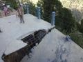
Polavaram--solution or problem?
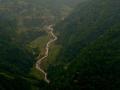
Dam history will be repeated with the construction of the Polavaram Dam. Unfortunately, other options that could have been looked into such as reduction of height, were ignored. Posted on 21 Sep, 2015 11:13 AM

Papi kondalu, a scenic gorge located on the lower stretches of the Godavari, will soon be engulfed within the controversial Polavaram Dam. The river serves as a visitor’s delight as it winds through the hills--the same hills that are home to primitive tribal groups such as the Kondareddys.

Papi kondalu gorge on Godavari (Source: Pranay Raj, Wikimedia Commons)
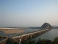
Godavari, Krishna rivers are interlinked
News this week Posted on 14 Sep, 2015 10:21 PM

Godavari, Krishna rivers interlinked

Prakasam Barrage across Krishna river (Source: Subhash Chandra via Wikipedia)
Long-delayed Teesta-III project in Sikkim gets cleared
Policy matters this week Posted on 14 Sep, 2015 08:26 PM

Teesta-III project in Sikkim gets a green signal

The meandering Teesta river (Source: IWP Flickr Photos)
Bisalpur revisited--10 years after protesters were shot, killing 5
Despite many plans, neither rural nor urban are water secure thanks to the Bisalpur Dam since it was constructed in 2007. Posted on 10 Sep, 2015 01:20 PM

Ten years ago five farmers were shot protesting the diversion of waters from Bisalpur dam to Jaipur city, located about 130 kms away.

Kisan Sewa Samiti, Chaksu struggling for drinking water allocation from Bisalpur dam (Source: CECODECON)
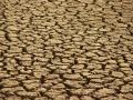
2015 is India's driest year since 2009
News this week Posted on 07 Sep, 2015 10:19 PM

40% of India still rain deficit

Parched area near Jodhpur (Source: India Water Portal Flickr Photos)
No more dam approvals until e-flow report is out: Water Ministry
Policy matters this week Posted on 07 Sep, 2015 09:35 PM

No approval of dams until e-flow report is out: Water Ministry to CWC

Kelo dam near Raigarh (Source: India Water Portal Flickr Photos)
Access to water data: Implications for transboundary relations in the Ganges river basin
Despite the enactments of RTI laws and insistence for openness in the government, access to information regimes on transboundary rivers has not changed at a fundamental level in South Asia. Posted on 05 Sep, 2015 12:21 PM

Citizens right to access information on water, climate and environmental issues

A view of the Sharada river at Lucknow, Uttar Pradesh (Source: Wikimedia Commons)
Europe's Rhine river inspires the Ganga revival
News this week Posted on 24 Aug, 2015 09:13 PM

Ganga clean-up takes its inspiration from the Rhine river

Ganga river at Varanasi (Source: India Water Portal Flickr Photos)
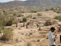
People in Kinnaur are making all efforts to stop further destruction'
The Environics Trust collaborated with Himalaya Niti Abhiyan to assess the impact of hydropower projects in Kinnaur, Himachal Pradesh. R Sreedhar of Environics Trust talks about this to IWP. Posted on 24 Aug, 2015 01:01 PM

Around 21 major hydropower projects are proposed in the upper Satluj catchment area of Himachal Pradesh. In 2013, The Environics Trust collaborated with Himalaya Niti Abhiyan to assess the impact of these projects on the people and ecology of the geographically-fragile Kinnaur region.

At Pangi village, several houses have suffered damage due to a hydel project.
×