Rivers

Featured Articles
November 25, 2022 These maps at the watershed scales have been made to not only ensure inclusion of different freshwater ecosystems, their connectivity and hydrological processes, but can also provide a spatial context for conservation decisions.
A stream at Anini, Arunachal Pradesh (Image Source: Roshni Arora)
October 30, 2022 This book by Dr. Mitul Baruah presents a fascinating, ethnographic account of the challenges faced by communities living in Majuli, India, one of the largest river islands in the world, which has experienced immense socio-environmental transformations over the years, processes that are emblematic of the Brahmaputra Valley as a whole. This is an excerpt from the book.
Floods are recurrent phenomena in Assam (Image: Mitul Baruah)
October 11, 2022 In an effort to inform the general public, especially citizen activists, policymakers, researchers, and students, about the current status of the Vrishabhavathi river, Paani.Earth has created the necessary maps, data, analysis, and information to drive conservation awareness and action around the river.
Vrishabhavathi river (Image Source: Paani.Earth)
October 6, 2022 Rapid urbanisation and faulty land use policies are rapidly destroying forests, grasslands and wetlands in Jammu and Kashmir, India and the ecosystem value services they provide. Can these valuable ecosystems be saved?
Deteriorating ecosystems of Jammu and Kashmir, India (Image Source: tkohli at Flickr via Wikimedia Commons)
September 5, 2022 In an attempt to present a perspective on how rivers are used and abused, a map of the Bengaluru rivers illustrate how waste flows through natural river corridors, polluting the rivers and altering their status.
Vrishabhavathi river flow at Thagachguppe Bridge, Kumbalgodu (Image Source: Paani.Earth)
August 11, 2022 This could lead to water quality crisis reinforcing the need for basin-specific management strategies
Around the world, more than a fifth of nitrogen released by human activity ends up in aquatic ecosystems (Image: Wikimedia Commons)
Impact of climate change on the Himalayan glaciers
40% reduction has occurred in the Himalayan glaciers in the last 40 years. 67% of the glaciers have retreated in the last decade. Gangotri is retreating at the rate of 28 m per year. Global warming and its consequent melting of glaciers would result in floods, fast and furious run-offs, erosion of the topsoil and sedimentation of the rivers. This could also lead to changes in the course of the rivers in the region. Posted on 26 Aug, 2009 03:30 PM

The Himalayas' permanent ice cover is around 97,000 sq.km. with 12,930 sq.km. volume of ice and snow: 10-20 % are covered by glaciers and 30-40% are seasonal snowfalls. The Himalayan streams and rivers are fed by the melting of snow and ice of approximately 500 sq.km / year.

International day of action for rivers
March 14 is observed as International Day of Action for rivers Posted on 26 Aug, 2009 02:19 PM

It is a day when existing river protection campaigns re-dedicate to the cause.

Read more

The River Care volunteer handbook
The River Care Volunteer Handbook, developed by Anglianwater, EnCams, and Environment Agency, is a ready reckoner to get you started on mobilizing people and organizing campaigns for cleaning the river in your area. Posted on 26 Aug, 2009 02:06 PM

Click on the link below to download the handbook.

How changing climate and melting glaciers affects nations across the globe: Spotlight on the Himalayas
In the next decade, the Himalayas are projected to suffer from devastating Glacial Lake Outburst Floods (GLOFs) and landslides - Is climate change the culprit? Posted on 25 Aug, 2009 05:11 PM

As observed by the United Nations Environment Program (GRID-Arendal) ice and snow are major components of the climate system. That is why human induced climate change can be first observed in Polar Regions where most of Earth's snow and ice are concentrated. In these areas global warming induces the progressive melting of ice and snow.

The many impacts of climate change - A serious global environmental issue?
Climate change due to the increasing concentration of GHGs in the atmosphere since pre-industrial times poses a huge threat and challenge to mankind. Posted on 25 Aug, 2009 03:14 PM

The earth is currently warming rapidly. And this warming is bringing about massive changes. Our glaciers are melting rapidly. The artic ice-shelf is breaking apart into pieces and threatens to modify the salinity of the oceans.

Films and video resources on climate change and greenhouse gas emissions from the Centre for Science and Environment
A list of films available at the CSE store on climate change and related issues Posted on 24 Aug, 2009 10:26 AM

A number of films on climate change are available on the Centre for Science and Environment (CSE) store. These include:

Rainwater harvesting in India: Traditional and contemporary
A brief look at the historical development of traditional rainwater harvesting systems of India ans also issues, need and relevance of RWH in the urban context Posted on 21 Aug, 2009 12:41 PM

The document informs that traditionally Indians worshipped both water and rain as “Jala” and “Varuna”. Even rivers were worshipped. Till 3000 B.C., RWH happened without human effort as rain got collected in rivers and natural depressions. Civilizations flourished on river banks all over the world Indus valley civilization in India.

Map: Location of water resource projects across river basins in India
This map from the National Institute of Hydrology shows the location of the various water resources projects in each river basin in the country. Posted on 20 Aug, 2009 03:23 PM

The map indicates that across the main 19 river basins of the country, water resource projects with a total live storage of 174 BCM (Billion Cubic Metres) have been completed, 75 BCM are ongoing, and 132 BCM are being planned.

Annual average availability of water for agriculture in India as of 1991
This map shows the river basin-wise annual average availability of water (in m3) for agricultural cultivation, as of 1991 Posted on 20 Aug, 2009 02:50 PM

/sites/default/files/iwp/Basin-wise%20annual%20average%20availability%20of%20water%20for%20agriculture_1991_NIH.jpg

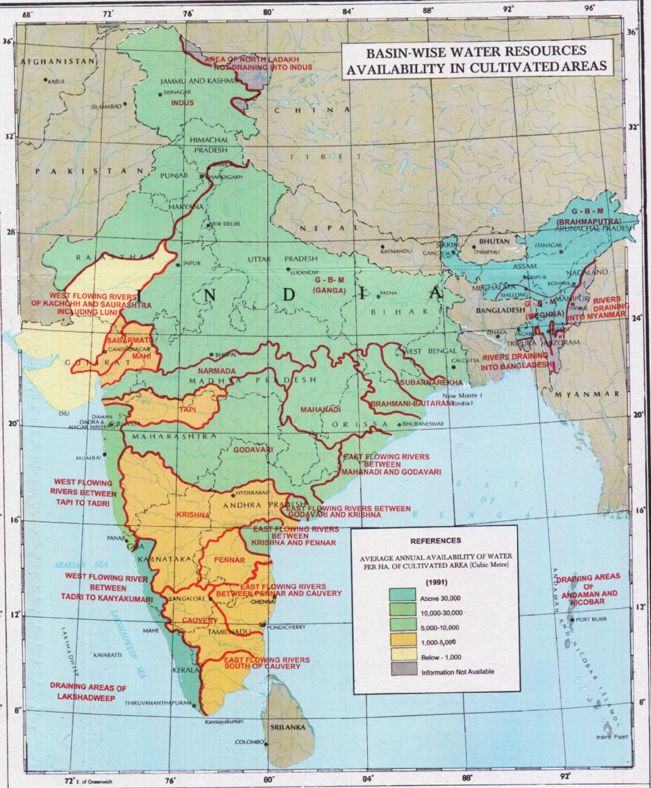
Chennai metropolitan area's water woes: CMWSSB's plans for the future
Steps outlined by the Chennai Metropolitan Water Supply and Sewerage Board to meet the water demands of Chennai city Posted on 19 Aug, 2009 04:01 PM

CMWSSB or Metro Water was established in 1978 and serves 180 sq kms of area and 5.5 million population.

×