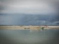
Droughts and Floods


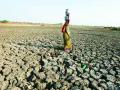
Drought in Andhra Pradesh - Long term impacts and adaptation strategies - A report by the World Bank
Posted on 29 Aug, 2009 03:11 PMThis report published by the World Bank consists of two volumes.
Volume 1 is divided into the following chapters:
Chapter1: Introduction
Chapter 2: Drought And Andhra Pradesh’s Economy: Historical Perspective
Chapter 3: Methodological Framework
Chapter 4: Reducing Vulnerability Of Agriculture To Drought In Eight Drought-Prone Districts
Chapter 5: Managing Economic Impact of Drought at the State Level
Chapter 6: Conclusions and recommendations
India's experience with drought management: Changed perspectives and challenges
Posted on 29 Aug, 2009 02:43 PMThis document describes the drought situation in India over the years, the earlier perspective at drought management and the gradual change in perspective at managing droughts that evolved over the years.
Reference: Impact of climate change on major river basins in India
Posted on 28 Aug, 2009 03:45 PMClimate and water resources of India, R. Ramesh* and M. G. Yadava; Current Science, VOL. 89, NO. 5, 10 SEPTEMBER 2005 - http://www.ias.ac.in/currsci/sep102005/818.pdf
Effect of climate change on river Kosi and its basin
Posted on 28 Aug, 2009 02:46 PMKosi is one of Ganga's largest tributaries and in turn is fed by 7 tributaries - Sun Koshi, Dudh Koshi, Indravati, Tama Kosi, Likhu, Arun, and Tamar. These tributaries encircle Mt Everest from all sides and are fed by world's highest glaciers. The river drains a total area of 69,300 sqkm upto its confluence with Ganga. The river basin stretches 54,000 sq.kms.
Effect of climate change on the Ganga-Brahmaputra delta regions
Posted on 28 Aug, 2009 02:28 PMThe delta belt is home to approximately 125-140 million people. And over 300 million people are supported by the delta. The density of population in the Delta region is 200 people / sq.km. making it one of the densest regions in the world.
The delta region is a high-rainfall region and receives 60-80 inches of rainfall every year.
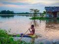
Migration and displacement due to sea-level rise: Mega-cities like Mumbai, Kolkata and Chennai could be hit hard
Posted on 26 Aug, 2009 05:34 PM125 million people are likely to migrate in the coming century of which 75 million will be from Bangladesh. The people from Bangladesh will most likely migrate to India in addition to our own 50 to 60 million people who will be displaced due to sea-level rise, shrinking water sources due to CC in the densely populated coastal regions of India.
References of the impact of climate change on river deltas and other coastal areas
Posted on 26 Aug, 2009 04:48 PMMumbai Marooned: An Enquiry into Mumbai Floods 2005 - Final Report ,
By Conservation Action Trust - Click here
Enquiry-mumbai-floods-2005-final-report
Glacier lake outburst floods: Wrecking havoc to life and property in the Himalayan region
Posted on 26 Aug, 2009 03:47 PMThese floods cause havoc with human life, flora and fauna of the area and the infrastructure in the region.
The Dig Tosho Glacier lake outburst in August 1985, destroyed the nearly completed Namche hydropower plant and all the rails, roads, and other infrastructure in its course.
How climate change has affected Ladakh: The region has seen unusual floods in July 2005 and August 2006
Posted on 26 Aug, 2009 03:36 PMIt is in Jammu Kashmir and is bordered by the Himalayas and the Karakoram mountain chains. Ladakh and its water sources are almost entirely dependent on the glaciers and snow-melts and changes in water systems can be directly attributed to changes in the glaciers and thus climate change.
Impact of climate change on the Himalayan glaciers
Posted on 26 Aug, 2009 03:30 PMThe Himalayas' permanent ice cover is around 97,000 sq.km. with 12,930 sq.km. volume of ice and snow: 10-20 % are covered by glaciers and 30-40% are seasonal snowfalls. The Himalayan streams and rivers are fed by the melting of snow and ice of approximately 500 sq.km / year.