Droughts and Floods


Indian floods leave 50 people dead, almost half a million displaced - Nita Bhalla
Posted on 08 Jul, 2010 04:15 PMArticle Courtesy : Reuters AlertNet
Written by: Nita Bhalla
NEW DELHI (AlertNet) - Floods triggered by heavy monsoon rains have killed more than 50 people and displaced almost half a million more in India's south and northeast, say government officials.
Overflowing rivers and reservoirs have inundated low-lying villages mainly in India's oil and tea-rich state of Assam, but also on the opposite side of country in the southwestern coastal state of Kerala.
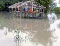
Flood-affected people sit in a damaged hut
as they wait for relief supplies in Lakhimpur
district, in India's northeastern state of Assam.
FILE PHOTO, July 2009. REUTERS/Stringer
According to the ministry of home affairs, almost one million people have been hit by the floods, forcing almost half a million to leave their water-logged villages and seek shelter in government relief camps.
Mountainous Assam, where five people have drowned, has been the worst-affected with 13 out of 27 districts hit by flooding, including Kokrajhar, Lakhimpur, Baksa and Bongaigaon.
Sensitivity analysis of hydrological parameters on flood hydrograph – A research report by National Institute of Hydrology
Posted on 07 Jul, 2010 11:06 PMIn this study, Clark’s model has been used for derivation of one-hour unit hydrograph for a catchment. The design flood estimate has been obtained using the calibrated parameters of the Clark model together with the time-area diagram corresponding to a 48-hour design storm, which has been temporally distributed and critically sequenced as a single bell, giving due consideration to the ordinates of the unit hydrograph.
Development of regional flood formula for Krishna basin – A research report by National Institute of Hydrology
Posted on 04 Jul, 2010 10:39 PMThis report describes the study of regional flood frequency analysis using peak flood series data of gauging stations of Krishna basin based on at site and regional data combined using the following methods: (a) Index-Flood method (b) PWM based EVI distribution (c) PWM based GEV distribution and (d) PWM based Wakeby distribution.
Flood studies in Satluj basin – A research report by National Institute of Hydrology
Posted on 01 Jul, 2010 01:17 PMThe study attempts to do flood inundation and flood plain feature mapping as well as undertake river planform measurements for a part of the river reach of Satluj. The river is a part of the Indus system and faces flood during monsoon months in spite of various flood control measures that have been adopted. The vast expanse of land adjoining the river course is inundated by large floods.
Hydrological aspects of flood disaster management - A research report by National Institute of Hydrology
Posted on 01 Jul, 2010 11:58 AMThe report deals with the hydrological aspects of flood disaster management, a multi-disciplinary field that endeavors to enhance the total productivity of the flood plains wherein losses are only a part of it. There are climatological and part-climatological causes of flooding and basin conditions, channel conditions and network conditions intensify floods.
Regional flood frequency analysis using L-moments - A research report by National Institute of Hydrology
Posted on 30 Jun, 2010 10:27 PMThe report presents regional flood frequency curves developed by fitting L-moment based GEV distribution to annual maximum peak flood data of small to medium sized catchments of the seven hydrometeorological sub-zones of zone 3 and combined zone 3 of India. The effect of regional heterogeneity is studied by comparing the growth factors of various sub-zones and combined zone 3. The flood frequency curves based on probability weighted moment (PWM) approach have been compared with the flood frequency curves based on L moment approach.
Rainfall-runoff modeling of Morel catchment for design flood estimation – A research report by National Institute of Hydrology
Posted on 28 Jun, 2010 08:56 PMIn the present study, design flood estimation of Morel catchment of Rajasthan state is computed using the Synder approach, regional relationships as proposed by Central Water Commission, Clark's model, Soil Conservation Services (SCS) method and Geomorphological Instantaneous Unit Hydrograph (GIUH) based approach.
Flood estimation for large catchments using deterministic approach – A research report by National Institute of Hydrology
Posted on 28 Jun, 2010 08:04 PMThe report presents an interactive software that has been developed to not only provide design flood estimates for large as well as small sized catchments but also help the users analyse their historical rainfall-runoff records for calibration and validation of the various techniques for part or whole of the catchment and river reaches.
Effect of channel characteristics on flood wave propagation - A research report by National Institute of Hydrology
Posted on 27 Jun, 2010 08:06 PMThe study attempts to explain flood wave propagation in natural and artificial channels within the perspective of site-specific rating curve. The study looks at the impacts of channel characteristics – bed slope, flood plains, channel shape, expansion-contraction combination, inactive storage, Manning’s roughness, expansion and contraction on flood wave propagation.
Modeling of flow in the canal due to breach of bank - A research report by National Institute of Hydrology
Posted on 27 Jun, 2010 12:15 AMThe study develops the wavelet element method for hydrological application purposes in general and modeling of flow in a canal due to breach of bank in particular. Due to high seasonal variability of rainfall and cyclones in coastal India, flood discharges cause frequent breaching of canals.
Canal breach modeling is of great significance in open channel hydraulics. The study of breach of a canal is a relatively new one as compared to dam breach, which is a well researched field. The analysis of the problem is complicated due to dynamics of flow within the canal. The limitations of the above model due to the one-dimensional model analysis of the problem is hoped to be overcome in two or three dimensional analysis.