Rivers

Featured Articles
November 25, 2022 These maps at the watershed scales have been made to not only ensure inclusion of different freshwater ecosystems, their connectivity and hydrological processes, but can also provide a spatial context for conservation decisions.
A stream at Anini, Arunachal Pradesh (Image Source: Roshni Arora)
October 30, 2022 This book by Dr. Mitul Baruah presents a fascinating, ethnographic account of the challenges faced by communities living in Majuli, India, one of the largest river islands in the world, which has experienced immense socio-environmental transformations over the years, processes that are emblematic of the Brahmaputra Valley as a whole. This is an excerpt from the book.
Floods are recurrent phenomena in Assam (Image: Mitul Baruah)
October 11, 2022 In an effort to inform the general public, especially citizen activists, policymakers, researchers, and students, about the current status of the Vrishabhavathi river, Paani.Earth has created the necessary maps, data, analysis, and information to drive conservation awareness and action around the river.
Vrishabhavathi river (Image Source: Paani.Earth)
October 6, 2022 Rapid urbanisation and faulty land use policies are rapidly destroying forests, grasslands and wetlands in Jammu and Kashmir, India and the ecosystem value services they provide. Can these valuable ecosystems be saved?
Deteriorating ecosystems of Jammu and Kashmir, India (Image Source: tkohli at Flickr via Wikimedia Commons)
September 5, 2022 In an attempt to present a perspective on how rivers are used and abused, a map of the Bengaluru rivers illustrate how waste flows through natural river corridors, polluting the rivers and altering their status.
Vrishabhavathi river flow at Thagachguppe Bridge, Kumbalgodu (Image Source: Paani.Earth)
August 11, 2022 This could lead to water quality crisis reinforcing the need for basin-specific management strategies
Around the world, more than a fifth of nitrogen released by human activity ends up in aquatic ecosystems (Image: Wikimedia Commons)
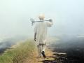
Rurals move away from agriculture: Assocham
News this week: Rural employment in agriculture reduces significantly; Activists demand 'Sarus Safari' in UP; 285 people in Karnataka died drinking contaminated water between 2010-13. Posted on 02 Feb, 2014 10:08 PM

'Rural job profile observes a significant change'

Decline in agriculture (Source: Neil Palmer, CIAT)
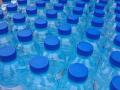
Authority bans sale of packaged drinking water without BIS mark
Policy matters this week: FSSAI declares no selling of packaged drinking water without BIS mark; President gives nod to Maharashtra groundwater bill; Govt opposes tribals way of cultivation. Posted on 02 Feb, 2014 10:07 PM

No sale of packaged drinking water without BIS mark: FSSAI

Packaged drinking water (Source: Ricardo Bernando)
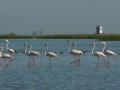
Bird sanctuary Chilika designated 'Destination Flyways'
News this week: UN to develop strategies to protect migratory birds in Chilika, Odisha; Cochin estuary has highest in toxicity in the world; Jaipur farmers in conflict with bottling plant. Posted on 29 Jan, 2014 12:29 PM

Chilika lagoon named as 'Destination Flyways' by UN

Chilika bird sanctuary, Odisha (Source:Aditi Pany)
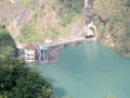
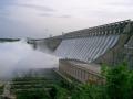
Power corridors for each river basin in Himachal
Policy matters this week: Expert team moots plan to develop power corridors for each basin; Maharashtra govt to make drip irrigation a must for cash crops; DJB to formulate policy to treat greywater. Posted on 29 Jan, 2014 12:28 PM

Plans to create power corridors for each river basin on its way

Hydropower transmission (Source: Wikipedia)
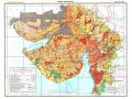
Mapping land and water resources in India
With rare maps of India including 'Annual Rainfall' map, 'Water Balance' map and 'Land Use' map, the land and the water resource development atlases are excellent sources of information. Posted on 27 Jan, 2014 01:18 PM

India’s mapping activity dates back to the Indus Valley Civilization (c. 2500–1900 BCE) as per the famous geographer, Joseph E. Schwartzberg. His work is based on a couple of surveying instruments and measuring rods that were excavated from the Indus valley sites. Our mapping traditions were influenced by Vedic, Tibetan, Islamic and more recently, British cartography.

Water resources development in Gujarat (NATMO)
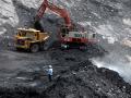
Ministry eases green norms for coal mine expansion
Policy matters this week: MoEF eases green norms for expanding coal mines; government to undertake review of existing water-related laws; site visit becomes mandatory before forest land diversion. Posted on 21 Jan, 2014 03:31 PM

Green norms eased for expanding coal mines

An open cast mine (Source: Garavi Gujarat)
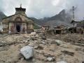
Channel Mandakini to its original course: GSI
News this week: GSI recommends channeling Mandakini river to its original course; Sohra experiences one of the driest year; HC orders close down of 12 units in Mundra SEZ, Gujarat. Posted on 21 Jan, 2014 03:29 PM

GSI report suggests channeling Mandakini river

Uttarakhand floods (Source: The Hindu)
Which way will the water flow?
The 12th Five Year Plan recognises that our current methods of water management have led to inequity. It suggests an approach that involves more input from non-government sources. Posted on 15 Jan, 2014 11:07 PM

In the 60-odd years since we began managing our own resources, we have managed to throttle and poison all our rivers, suck our groundwater resources nearly dry and shave our forests bald. This is despite a great deal of effort, time, thought and resources that have gone into this 'management'.

Ramaswamy Iyer, former Secretary Water Resources
Improved sanitation can reduce diarrhoea cases by 47%
Policy matters this week: Diarrhoea cases can come down with improved sanitation, SC tells Centre to appoint Regulator for environment matters and new water scheme for rural areas. Posted on 14 Jan, 2014 06:41 PM

Improved sanitation can reduce diarrhoea cases by 47%: World Bank

Sanitation means good health (www.thinkaboutit.eu)
Sikkim's citizens say NO! to dams
90% of people living around dams in Sikkim testify to environmental damage, increased hazards and decreased resources. Can their situation be changed? Posted on 13 Jan, 2014 02:18 PM

Hydropower is considered as 'green' power and the Sikkim Government's policy has been to synchronize development imperatives with conscious efforts on environment sustainability. This paper presents the results of a survey carried out among communities living along a 54-km long project affected stretch of the Teesta river.

Dams intensify the impact of earthquakes
×