Rivers

Featured Articles
November 25, 2022 These maps at the watershed scales have been made to not only ensure inclusion of different freshwater ecosystems, their connectivity and hydrological processes, but can also provide a spatial context for conservation decisions.
A stream at Anini, Arunachal Pradesh (Image Source: Roshni Arora)
October 30, 2022 This book by Dr. Mitul Baruah presents a fascinating, ethnographic account of the challenges faced by communities living in Majuli, India, one of the largest river islands in the world, which has experienced immense socio-environmental transformations over the years, processes that are emblematic of the Brahmaputra Valley as a whole. This is an excerpt from the book.
Floods are recurrent phenomena in Assam (Image: Mitul Baruah)
October 11, 2022 In an effort to inform the general public, especially citizen activists, policymakers, researchers, and students, about the current status of the Vrishabhavathi river, Paani.Earth has created the necessary maps, data, analysis, and information to drive conservation awareness and action around the river.
Vrishabhavathi river (Image Source: Paani.Earth)
October 6, 2022 Rapid urbanisation and faulty land use policies are rapidly destroying forests, grasslands and wetlands in Jammu and Kashmir, India and the ecosystem value services they provide. Can these valuable ecosystems be saved?
Deteriorating ecosystems of Jammu and Kashmir, India (Image Source: tkohli at Flickr via Wikimedia Commons)
September 5, 2022 In an attempt to present a perspective on how rivers are used and abused, a map of the Bengaluru rivers illustrate how waste flows through natural river corridors, polluting the rivers and altering their status.
Vrishabhavathi river flow at Thagachguppe Bridge, Kumbalgodu (Image Source: Paani.Earth)
August 11, 2022 This could lead to water quality crisis reinforcing the need for basin-specific management strategies
Around the world, more than a fifth of nitrogen released by human activity ends up in aquatic ecosystems (Image: Wikimedia Commons)
Projects worth Rs 929 crore approved for the Ganga
Policy matters this week Posted on 08 Nov, 2018 02:39 PM

NMCG approves 12 projects worth Rs 929 crore under Namami Gange

A ghat at the Ganga riverbank (Source: IWP Flickr Photos)
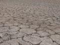
Few districts in the country drought resilient: Study
News this week Posted on 31 Oct, 2018 10:40 AM

Human activities are taking a heavy toll on country's resilience to drought

Parched land during drought in India. (Source: IWP Flickr Photos)
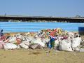
Performance audit for solid waste management
Policy matters this week Posted on 30 Oct, 2018 08:16 PM

NGT orders performance audit for management of solid waste

Solid waste at the sanitation park, Ambikapur (Source: IWP Flickr photos)
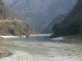
Artificial lake forms in Brahmaputra
News this week Posted on 23 Oct, 2018 10:27 AM

Artificial lake in Brahmaputra in China, flood threat in Arunachal Pradesh and Assam wanes

A flooded river in Assam (Source: IWP Flickr photos)
Maintain minimum flow in the Ganga river: Centre
Policy matters this week Posted on 16 Oct, 2018 12:57 PM

Centre notifies minimum e-flow for the Ganga river

Ganga river at Kaudiyala (Source: IWP Flickr photos)
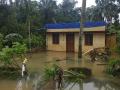
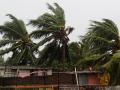
Cyclone Titli hits Odisha and Andhra Pradesh
News this week Posted on 16 Oct, 2018 12:38 PM

Cyclone Titli devastates Odisha and Andhra Pradesh

A file photo shows a severe cyclonic storm in progress. (Source: IWP Flickr photos)
Why floodplains need to be protected
Damage to floodplains harms the riverine ecosystem, lessens groundwater recharge capacity and poses threats of flash floods. Enforcement of floodplain zoning regulation is a must to avert floods. Posted on 12 Oct, 2018 11:56 AM

The Kerala flood of 2018 was 30 percent less intense than that of 1924 deluge, the biggest in Kerala’s history. Yet it caused a huge loss of lives, property and infrastructure. Swollen rivers ruptured their banks and floodwaters gushed through houses built on the floodplains.

Real estate development has wiped out large swathes of land on the active floodplain of the rivers in Kerala; the reduction in its cross section led to massive inundation during the Kerala floods, 2018.
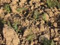
India's first soil moisture map out
News this week Posted on 10 Oct, 2018 11:37 AM

India gets its first soil moisture map developed using hydrological model

Soil moisture plays an important role in agriculture. (Source: IWP Flickr photo)
Lower Demwe hydel project gets nod from wildlife board
Policy matters this week Posted on 02 Oct, 2018 12:11 PM

Wildlife Board clears Lower Demwe hydel project despite flaws in report

Lohit river in Arunachal Pradesh (Image Source: Shantanu via Wikipedia Commons)
Kerala floods and after
The reason behind Kerala floods is a lot more than what the CWC wants us to believe. Posted on 27 Sep, 2018 05:11 PM

Every time there is a huge flood in India with massive loss of lives and extensive physical damage, there is a hue and cry. Especially, if this takes place in an area not normally prone to such floods. Assam and Bihar, for instance, are regularly laid waste by floods and so, there is not much agitation over that anymore.

The floods in Kerala have taken nearly 400 lives and have displaced around 1.2 million people. (Image: Ranjith Siji via Wikimedia Commons)
×