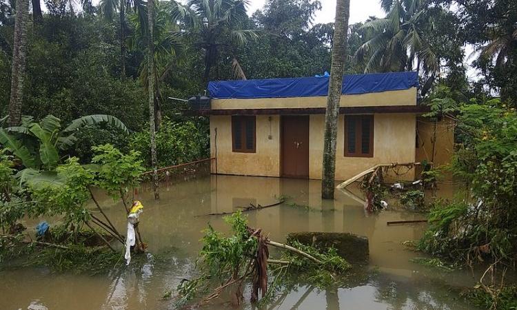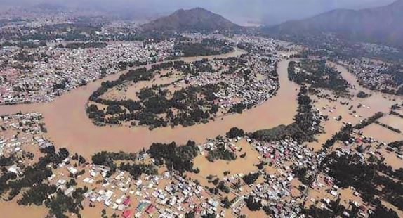
Every time there is a huge flood in India with massive loss of lives and extensive physical damage, there is a hue and cry. Especially, if this takes place in an area not normally prone to such floods. Assam and Bihar, for instance, are regularly laid waste by floods and so, there is not much agitation over that anymore. But when there were unprecedented floods in Uttarakhand, Kashmir, Chennai and Mumbai a few years back and now recently in Kerala, they invited massive outpouring of wrath followed by a blame game.
In the instance of Kerala, one particular allegation was that the many dams in the state were almost full to capacity even before the torrential rains began in late August and so they did not have much of a flood cushion to absorb the higher runoff coming into them. This led to the release of excess water downstream creating havoc. Stung to the quick by this allegation, the usually reticent Central Water Commission (CWC) decided to at least partially reveal the data.
The CWC has published a report in which it has analysed the data regarding the various river basins of Kerala and the impact of dams on floods. The crucial data that needs to be understood is that of the river flows at major dams and hydrological stations in the plains close to the sea where the floods mostly had a devastating effect in the urban areas.
The CWC, however, has given this data only for the biggest river Periyar which also has 47 percent of the live storage capacity of all the dams in Kerala. Even though there is data regarding the total runoff and the total flow in the river along with the amounts impounded in the dams, for all the basins that have been analysed by the CWC, this does not give us an understanding of the force of the floods at their peak. Therefore, the CWC's report falls short of this information.
Dams and their effect on floods

The Periyar basin has three major dams—the Mullaperiyar, followed by the Idukki on the main stem of the river and another on the Idamalayar tributary. The peak flood discharge in the river at the Neeleshwaram measuring site of the CWC in the plains near the sea during the height of the flood was 8800 cubic metres per second (cumecs). The outflow at the Idukki dam then was 1500 cumecs. The flood cushion that was there in the dam resulted in about 1000 cumecs being absorbed. However, if a greater flood cushion had been created by releasing water from the dam in phases earlier in the month, then another 1000 cumecs could have been absorbed. The Idamalayar dam on the tributary of the Periyar released another 1500 cumecs at its peak despite being a smaller dam as it had very little flood cushion. Being a smaller dam it could have absorbed another 500 cumecs if there had been more free live storage space in the dam.
In other words, the flood flow at Neeleshwaram would have been 7300 cumecs if these dams had been properly operated. This is more or less the case with the other smaller basins also as even if they had kept a flood cushion, given their much smaller live storage capacity as compared to the huge runoffs coming into them, they would not have been able to absorb much of this. The CWC, of course, goes overboard with this data and says that the lack of a designed flood cushion resulted in only a "miniscule" increase in the flood impact even though the increase is actually about 20 percent which is quite significant.
The important conclusion that comes from this analysis is that the dams, in general, have limited flood protection capacities, especially when faced with rainfall of such huge proportions ranging from 100 to 250 percent more than the normal for the month occurring in just three days. Even with proper operation of the dams by following the rule curve which prescribes the level of water to be kept at the reservoir at different times of the year for adequate flood cushion the disaster couldn’t have been averted though it would have reduced the flood impact. Actually, the need for hydropower, which is the primary aim of the biggest Idukki dam and most other dams in Kerala, led the dam operators to keep the reservoir levels high which eventually failed to provide a substantial flood cushion.
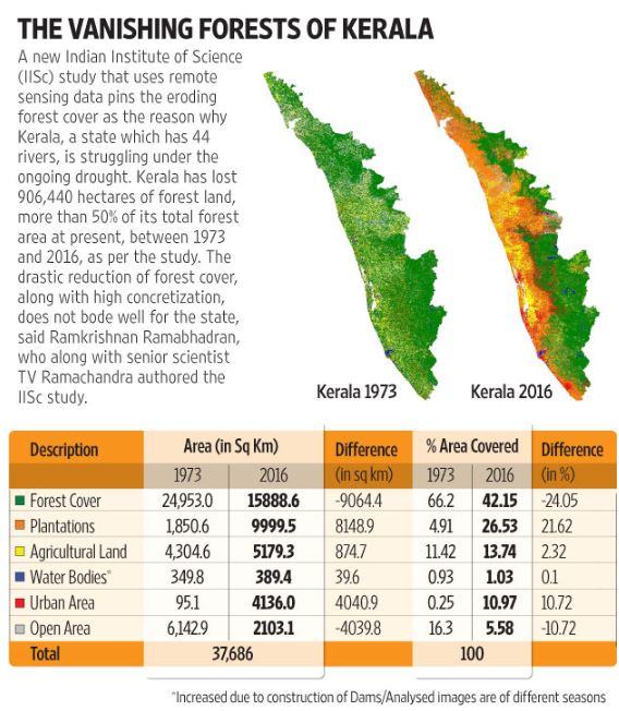
The main reason why the floods in Kerala were devastating is deforestation that has taken place in the Western Ghats along with quarrying for stones and minerals as is evident from the graph below.

This is compounded by the construction in paddy fields whose area has gone down from 8.5 lakh hectares earlier to just two lakh hectares now. The wetlands and the floodplains of rivers have also been encroached on. All these have together increased the runoff and also decreased the water holding capacity of the hills and the plains. The Vembanad Lake, which is a protected Ramsar site, into which several rivers drain has been encroached on and its capacity to hold water has been drastically reduced because of the huge urbanisation that has taken place around it. Consequently, it did not have the capacity to hold the huge runoff coming into it and overflowed and submerged the urban areas around it.
This massive deforestation and mining combined with indiscriminate construction on floodplains and fields is indeed the reason for floods in the Himalayas and their foothills. It is no different in the plains also whenever there is an extreme weather event resulting in concentrated precipitation in a short period of time.
Need for appropriate flood control measures
Flood control, not only in Kerala but throughout the country, thus, has to be brought about by greater soil and water conservation measures to increase artificial recharge and stabilisation of steep hill slopes and afforestation to increase natural recharge and reduce runoff. This will also have the benefit of sequestering carbon and preventing global warming and increase the availability of groundwater.
In the aftermath of floods, Kerala is facing a drinking water crisis because many of the wells and tubewells have been packed with mud and debris. Even though repeated floods over the past few years in various places have shown that business, as usual, will not do, we do not seem to learn. Four years ago, the Madhav Gadgil-headed Western Ghats Ecology Expert Panel had specifically said that the Western Ghats and especially the steeper section in Kerala and Tamil Nadu should be conserved as an ecologically-sensitive zone by banning construction activity. Their recommendations were vehemently opposed by all and sundry and the report was consigned to the wastepaper basket. The consequences of that are there for all to see.
The CWC, in its report, concentrates only on dams. It exonerates these dams by saying that they, even by design, did not have the capacity to mitigate floods resulting from such a heavy downpour. It takes a blinkered approach to suggest that some more dams should be built solely for the purpose of flood control. It completely ignores the need for augmenting artificial and natural recharge as it has in other areas also. For instance, in the Brahmaputra basin, the flow from the Tsangpo in China contributes only five percent of the total flow in the basin. So, if intensive soil and water conservation measures and afforestation are undertaken in the catchments of the rivers, then flood control, maintenance of environmental flow and drought proofing can easily be done. However, the CWC creates the false bogey of China either withholding and diverting or releasing excess water from the Tsangpo to create droughts and floods in India. Massive decentralised soil, water and afforestation programmes conducted through local governance bodies will also provide huge employment and create a flourishing natural resource base for sustainable development.
Rahul Banerjee is an Indore-based social activist and development researcher who works with Bhil Adivasis and Dalits.
Disclaimer: The views and opinions expressed in this article are those of the author/s and do not necessarily reflect the policy or position of India Water Portal.