Rivers


Organisations accepting donations at the wake of the Bihar floods, 2008
Posted on 04 Sep, 2008 08:46 AM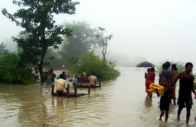
Courtesy: biharfloodrelief2008.blogspot.com
Sri. Dinesh Kumar Mishra on the flooding of Kosi basin,2008
Posted on 03 Sep, 2008 07:06 PMDr. Jagannath Mishra, former Chief Minister of Bihar, has given a pathetic description of floods in Bihar. He said that "Nobody from the government has gone to Saharsa so far. If the people in Saharsa are surviving, they must be saying that we are engulfed in water since ten days and nobody is there to think about us. This is quite worrisome. I will suggest that we must try to look after those surviving there. We must try to save them, whether by boats or a helicopter.. The flood in Saharsa is not a flood, this is unprecedented¦.we cannot call it a flood, it is a deluge." But wait, he is not talking about the recent floods (2008) in Bihar. He was making a speech in the Bihar Vidhan Sabha on the 13th September 1984 about a similar incident that took place on the 5th September 1984 near Navhatta in Saharsa district of north Bihar when the Kosi had breached its embankment at 75th kilometer south of the much talked about Bhimnagar Barrage and come out of the jacket just as it happened at Kusaha this year. Obviously, the powers that be refuse to take any lessons from the past mistakes and their executive wing, the Water Resources Department, is immune to any criticism and learning. The 1984 incident had uprooted nearly half a million people from their homes and hearths and engulfed 96 villages spread over 7 blocks of Saharsa and Supaul districts then. They could return to their homes only after the Holi festival in March 1985.
On the book shelf: Interlinking of Rivers in India, Issues and Concerns
Posted on 31 Aug, 2008 10:26 AM Key Features: Reviews the risks of inter-basin water transfers warns of critical disadvantages with India's proposed ILR plan offers viable less-risky solutions for water resource development. Inter-basin water transfers are complex human interventions on natural systems that can have profound adverse as well as beneficial social, economic and environmental implications. India's plan to interlink its rivers (ILR) and to transfer water may, according to one set of views, generate positive benefits through improved and expanded irrigation and may also contribute to flood and drought hazards mitigation for India, although the magnitudes are debatable. However, there are opposing views, in the context of India itself, that the interlinking plan is economically prohibitive, fraught with uncertainties, and has potential for disastrous and irreversible adverse after-effects. Water deficit can be reduced through improved water management without large scale engineering interventions. Moreover many of the rivers involved, particularly in the Himalayan component, are international and, therefore, the scheme has major implications for other riparians. Indeed, the planned transfer of water from the Ganges and Brahmaputra rivers will adversely impact Bangladesh socially, economically and environmentally---unless arrangements are made to maintain historical flows, which is unlikely to be feasible.
High Level Expert Group on the Bhagirathi river lacks required expertise
Posted on 28 Aug, 2008 10:05 PMAll is not well with the High Level Expert Group (HLEG) constituted on an order of the Government of India to determine the flow required to keep the Bhagirathi river 'alive and to ensure perennial environmental flow in the river'. It may be recalled that on June 30, 2008 the Government of India committed itself to "suitably ensure perennial environmental flow in all stretches of river Bhagirathi."This commitment was made in response to a representation of the Alumini Association of IIT- Kanpur to the Prime Minister of India requesting his intervention in the fast-unto-death undertaken by Dr. G.D. Agrawal , a former Dean of IIT-Kanpur -- to ensure the natural and uninterrupted flow of the Bhagirathi river between Gangotri and Dharasu (Uttarkashi). Subsequently the Ministry of Power, GoI, directed Shri R.S. Sharma, Chairman & Managing Director of NTPC, to constitute a high level expert group. The biggest problem with the HLEG is that it lacks the necessary scientific expertise to comprehensively address the issue. In a letter to Shri R.S. Sharma, rejecting his invitation to be a member of the HLEG, Dr G.D. Agrawal wrote, "Several members of the HLEG as constituted (including its Chairman) fall extremely short on any sort of expertise on river ecology and environmental flows...The commitment of most proposed members towards conservation of Bhagirathi Gangaji as the mother of India's faith, unity and culture is also questionable and I cannot afford to provide credibility to its deliberations and conclusions by being an ordinary member of the group."
Flood situation report in Supaul district compiled by Megh Pyne Abhiyan
Posted on 28 Aug, 2008 09:42 AMAbout the Report: The flood situation report has been a joint effort of Megh Pyne Abhiyan's (literally clouds' water campaign, involving people around the issue of water and livelihood, and a functional network of grassroots organizations) partners - Gramyasheel, Supaul; Kosi Seva Sadan, Saharsa; Samta, Khagaria, Ghoghardiha Prakhand Swarajya Vikas Sangh, Madhubani; SAVERA, West Champaran; Luisa Cortesi and Eklavya Prasad in assistance with Santosh Jha of Gram Bharti, Raghopur.Supaul. For compiling the situation report, two days of field visit was undertaken by the team, involving extensive interaction with affected villagers from India and Nepal, discussion with members of civil society groups, deliberations with government officials (Sub Divisional Magistrate and Dy Superintendent of Police, Tribeniganj; District Magistrate, Supal) and internal exchange of idea between the partners of Megh Pyne Abhiyan (MPA) and the supporting organizations. During the field visit, the group started to explore the option of establishing a district level coordination group comprising of eminent personalities and professionals, representatives of non governmental organizations and media, to coordinate and steer the rescue and relief work with individuals, government agencies, non government organizations, donor agencies, corporate bodies etc. Hence, on 25th August during a district level meeting of local organizations, activists and donor agency, a consensus was reached to set up a coordination group, named as the Flood Action Coordination Group (FACG), Supaul.
General overview of the River: On the 18th of August the eastern embankment of Kosi near Kusaha in Nepal's Sunsari district breached. The breach itself has caused colossal loss of life and property in the south east tarai region of Nepal and in six districts of north Bihar, affecting more than 2.5 million human lives. After the breach, the river has shifted its course nearly 100 kilometres (kms) eastward from its earlier course (which use to pass through the districts of Supaul, Saharsa, Madhubani, Darbhanga and Khagaria).
Access the entire report:
KRAPAVIS:Reviving "Orans" physically and conceptually
Posted on 13 Aug, 2008 04:39 AMOrans are local micro bio-diversity reserves- community conserved areas (CCAs) harboring the shrine of a local goddess or deity. Also known as Dev-banis, these local forests vary in size from a hundred to five hundred bighas (about hundred hectares). Most Orans have sources of water, either small springs or rivulets running through them or a variety of ponds and nadis in their midst.
Environmental flows discussion-From the perspective of the National Water Academy
Posted on 02 Jul, 2008 09:31 AMParineeta Dandekar's earlier post on environmental flows, triggered several responses and we have initiated a discussion forum
Latest from AAQ and discussion forum
Posted on 17 Jun, 2008 09:40 AMWould you throw your lot in with cloud seeding, or have ideas regarding conservation and regulated usage? Feel free to join in and have your say, access the Drought Mitigation Discussion here
Invitation for joining URAN PSI group
Posted on 18 May, 2008 10:48 PMSeveral threats have emerged in recent years to the pristine Himalayan rivers of Uttarakhand. These include: (i) the proposed construction of 220 dams (ii) the drying up of rain fed rivers due to deforestation and deforestation of their catchments (iii) release of untreated sewage from river side towns and habitations and (iv) illegal sand mining of river beds.
Prof.G. D. Agrawal's satyagraha against the construction of dams on the Bhagirathi River
Posted on 17 May, 2008 09:08 AM
Pained by the unrelenting destruction of the Ganga river, especially by a series of dams in its upper reaches, Dr G.D. Agrawal, India's pre-eminent environmental quality scientist and a legendary Professor (and HoD) of Civil & Environmental Engineering at IIT-Kanpur. (Access:Biography Sketch Here) has decided to go on a fast-unto-death to oppose its continuing desecration. His conviction that we are staring at an unprecedented ecological and cultural catastrophe comes from his powerfully logical mind. Critique on proposed dams on Bhagirathi River. Access here: Critique on Dams