Rivers
Micro-watershed development plans using remote sensing and GIS for Shetrunji river basin in Bhavnagar district, Gujarat
Posted on 11 May, 2009 04:21 PMMicro-watershed level planning requires a host of inter-related information to be generated and studied in relation to each other. Remotely sensed data provides valuable and up-to-date spatial information on natural resources and physical terrain parameters.
Improving flood management and water quality: a case study of Chicago, United States of America
Posted on 11 May, 2009 02:23 PMThese presentations deal with a case study of the work done in Chicago City in the United States of America to improve flood management and water quality. In order to save construction costs, the reservoir side walls are composed of geomembrane liner over compacted clay.
Environment action plan for the city by Bangalore water supply and sewerage board
Posted on 11 May, 2009 12:38 PMThis presentation by the Bangalore Water Supply and Sewerage Board deals with the Environment Action Plan (Part – B) for Bangalore. The presentation begins with a description of the drainage pattern of the city and the major rivers in and around it. The objectives of the EAP are set out as –
- Stopping flow of raw sewage into storm water drains.
- Achieving zero discharge of raw sewage into drains.
- Conveying sewage to treatment plants and treating to meet standards.
- Improving environment.
- Improving socio-economic status.
NASA Earth Observatory: Cyclone Bijli
Posted on 07 May, 2009 12:03 PMImage & Content Courtesy: NASA Earth Observatory
 A ragged-looking Tropical Storm Bijli draped the east coast of India in this image from the Moderate Resolution Imaging Spectroradiometer (MODIS) on NASA's Terra satellite on April 16, 2009. Bijli became a tropical storm in the northwest Bay of Bengal on April 15, and initially headed north, toward the west coast of India. By April 16, it had begun a northeastward turn, however, and the storm was being projected to make landfall in eastern Bangladesh on April 17, according to Unisys. Access higher resolution image here:Cyclone Bijli
The Sambalpur declaration on Odisha rivers : Let the river flow
Posted on 23 Apr, 2009 12:04 PMWater Initiatives Orissa(WIO) and the Indian River Network (IRN) organsied the Odisha River Conference during 18 - 20 April 2009 at Sambalpur, Odisha. Attended by about 75 participants which included activists, environmentalists, journalists, academicians, researchers and civil society representatives from across the country, the Conference has just concluded with a "Sambalpur Declaration" that calls for saving the rivers from the current fate of high rate of degradation and giving communities their traditional rights over the rivers, among other strong resolutions.
Basin maps of Mahanadi river showing basin indicators, landcover classes and biodiversity information and indicators
Posted on 17 Apr, 2009 02:07 PM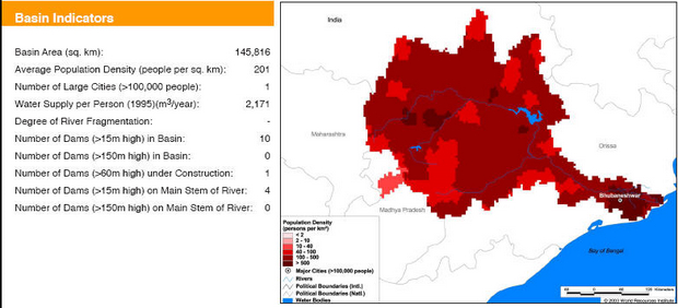
Basin indicators map of Mahanadi river basin
Basin maps of Krishna river showing basin indicators, landcover classes and biodiversity information and indicators
Posted on 17 Apr, 2009 01:25 PM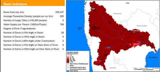
Basin indicators map of Krishna river basin
Basin maps of Indus river showing basin indicators, landcover classes and biodiversity information and indicators
Posted on 17 Apr, 2009 01:05 PM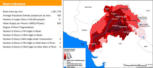
Basin maps of Narmada river showing basin indicators, landcover classes and biodiversity information and indicators
Posted on 17 Apr, 2009 12:55 PM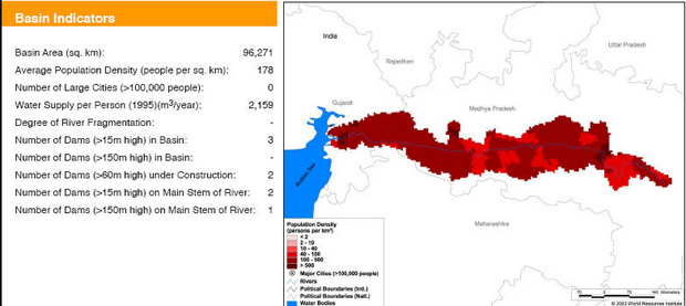
Basin indicators map of Narmada river basin
Basin maps of Godavari river showing basin indicators, landcover classes and biodiversity information and indicators
Posted on 17 Apr, 2009 12:42 PM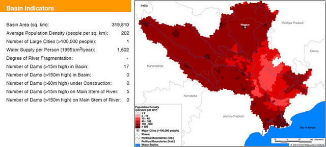
Basin indicators map of Godavari river basin


