Rivers


The impacts of water infrastructure and climate change on the hydrology of the Upper Ganges river basin – A research report by IWMI
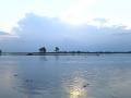
Posted on 18 Dec, 2011 07:03 PM The Ganges river system originates in the Central Himalayas, and extends into the alluvial Gangetic Plains and drains into the Indian Ocean at the Bay of Bengal. In the upstream mountainous regions, hydropower is the main focus of development with mega and micro projects either under construction or being planned in both Nepal and India.
After the main river channel reaches the plains, it is highly regulated with dams, barrages and associated irrigation canals. All this infrastructure development and abstractions affects the river’s flow regime and reduces flows, which, in turn, impacts downstream water availability, water quality and riverine ecosystems. Furthermore, there are concerns that climate change is likely to exacerbate the water scarcity problem in the Ganges Basin. Therefore, modeling the hydrology of the basin is critical for estimation, planning and management of current and future water resources.
Yamuna-Elbe - A public art and outreach project at the Yamuna riverscape in Delhi launched on 5 November, 2011
Posted on 18 Dec, 2011 02:02 PMGuest post by: Amita Bhaduri
The public art outreach project was organized by the Max Mueller Bhavan in association with the Government of Delhi and the Goethe-Institut (Hamburg, Germany) as a part of the “Year of Germany in India” programme opened on 5th of November, 2011. The art exhibition which continued till the 19th of November co-curated by artist Ravi Agarwal who is also a practicing environmentalist (Director, Toxics Link) along with German artist, Till Krauser attempted to create a pulsating synergy between the Yamuna and Elbe rivers.
 Gigi Scaria’s - The fountain of purification
Photo courtesy: Rocky Thongam
This is a 24 ft installation representing a four storey apartment complex that draws Yamuna water, purifies it at various levels and dispenses it from the top in the form of a fountain.
The Mullaperiyar dam debate - An issue of safety versus rights?
Posted on 12 Dec, 2011 10:40 AMThe issue that has been making headlines in the last few days has been that of the continuing debate between the states of Kerala and Tamil Nadu over the Mullaperiyar dam. This debate has opened up a number of issues related to the ownership and use of water between the two states of Tamil Nadu and Kerala in the context of the current changes and the loss of relevance of the laws and decisions made during the colonial rule; the water sharing, irrigation and power generation needs of both the states; and the recent concerns on the safety of the dam in Kerala versus the urgent irrigation needs of the agricultural sector in Tamil Nadu.

A view of the Mullaiperiyar dam on Kerala-Tamil Nadu border at Kumili.Photo: Vibhu
Image Source: The Hindu
This article sheds light on the history of the Mullaperiyar dam and the background for the current deadlock between the two states over the dam. The current deadlock between the two states over the dam is essentially not a dispute for water, but has its roots in the colonial times, and has to do with the need to come to terms with the agreements and decisions made in those times with changing economic, political and environmental contexts and concerns about the safety of the dam in Kerala versus the irrigation needs of the farmers in the state of Tamil Nadu.
Fishery statistics – A manual by Ministry of Statistics and Programme Implementation
Posted on 11 Dec, 2011 10:08 AM It has a ready to use reference guide on methodological aspects of data (metadata) based on harmonized concepts and methodologies that facilitate international comparison and help in aggregation of statistics to derive meaningful conclusions. The adoption of the methodology suggested in this manual will go a long way in facilitating data aggregation and data comparison both at intra-regional levels, including international levels.
The section on both marine and inland fisheries consists of four chapters and appendices. Chapter I highlights the significance of the sector, need for statistical standards and development of statistical system of the sector. Concepts and definitions are placed in Chapter II. Chapter III presents sources of data and details of methodology being adopted for generating these data. Chapter IV conveys the suggestion for ensuring quality standards. Lastly, appendices include estimation methods, forms and schedules and major resources available in the Indian waters.
Bringing life back to Chilika lagoon in India
Posted on 28 Nov, 2011 10:34 AMContent and Media Courtesy: International Union for Conservation of Nature
This 116,500 hectare brackish lagoon separated from the Bay of Bengal by a long sandy ridge was added to the Ramsar List of Wetlands of International Importance in 1981.This was because the lagoon was facing serious degradation due to siltation and choking of the seawater inlet channel, resulting in the proliferation of invasive freshwater species, the decrease in fish productivity, and an overall loss of biodiversity [1].
Gravity based spring water supply systems in Andhra Pradesh: Lessons and steps towards the future
Posted on 22 Nov, 2011 07:35 AMGuest post by – Rahul Bakare, Arghyam
This article details an example where local knowledge has been used to develop access to safe water in the tribal areas of the Eastern Ghats in Andhra Pradesh
Northeast monsoon causes floods in parts of Tamil Nadu and Kerala, some snowfall in Kashmir: News Roundup (01 to 15 November 2011)
Posted on 22 Nov, 2011 07:26 AMThe news this fortnight has been dominated by the north-east monsoon in South India, mainly in Tamil Nadu and Kerala. Periyar, Vagai, Krishnarajasagar, Mettur and Chemberampakkam reservoirs have either reached full capacity or are expected to in the next few days. Areas downstream of Vagai reservoir received flood warnings.
In the cities of Tamil Nadu, heavy rains and inadequate infrastructure have led to damage to life and property, with 10 people dead in two separate incidents.
Winter precipitation has begun in Kashmir, with the higher reaches receiving snowfall.
A river runs through us: An award-winning film on the threats faced by our rivers
Posted on 18 Nov, 2011 03:32 PMArticle and media courtesy: International Rivers
Workshop on 'Latest trends in Dam Safety', Aqua Foundation, November 19th, 2011, New Delhi
Posted on 18 Nov, 2011 09:47 AMOrganizer: Aqua Foundation
Venue: India Habitat Centre, Lodhi Road, New Delhi

Description:
Aqua Foundation is pleased to announce one day workshop on 'Latest Trends in Dam Safety' to be held at India Habitat Centre, New Delhi, on November 19th 2011. The workshop is being held as post conference workshop after international exhibition and conference of water being held at the same venue from November 16th to November 18th 2011.
Living rivers, dying rivers: Rivers in North East India
Posted on 15 Nov, 2011 03:29 PMRivers in North-East India