News and Articles
Ecological destruction of Loktak, the largest freshwater lake in North East India – A five-part FES-InfoChange series
Posted on 13 Nov, 2010 07:18 PM This series by Thingnam Anjulika Samom deals with the impact of modernisation, development and state policy on the traditional use, control and management of Loktak lake, the largest common property aquatic resource in Manipur. The Loktak Hydropower Project commissioned in 1983 has damaged the ecology of the largest freshwater lake in the northeast, and has altered the culture, agricultural and livelihood patterns of communities residing around Loktak. The series looks at what this common property resource used to be and what it has become.
Loktak, the 300-square-km lake is spread over three districts in the valley – Imphal West, Bisnupur and Thoubal and covers 61% of the total identified wetlands of Manipur. Besides being the source of livelihood for hundreds of people, Loktak also houses the floating national park Keibul Lamjao, the only home in the world to the endangered Sangai deer. It is not only the geographical topography of the lake that has changed in the last few decades. The lake is also beset by increasing pollution, siltation, rapid proliferation of phumdis and the commissioning of the Loktak hydel project in the 1980s Manipur or Imphal River, with the Loktak lake forming the headwaters to provide regulated storage for power generation.
Coastal Regulation Zone notification (2010) - Critique by the Kerala Swathanthra Malsya Thozhilali Federation
Posted on 12 Nov, 2010 08:05 PM

The Ministry of Environment and Forests (MoEF) has issued the draft CRZ Notification, 2010 under the Environment (Protection) Act, 1986 on 15th September, 2010 inviting suggestions and objections from public within 60 days from date of its issue. The following are the new additions to the original 1991 notification:
The burden of cholera in the slums of Kolkata - A community based study by NICED
Posted on 12 Nov, 2010 12:29 AMThis paper by National Institute of Cholera and Enteric Diseases (NICED) is based on a prospective, community based study in an impoverished urban site in Kolkata in order to measure the burden of cholera, describe its epidemiology, and search for potential risk factors that could be addressed by public health strategies. The study population was enumerated at the beginning and end of the study period. Surveillance through five field outposts and two referral hospitals for acute, watery, non-bloody diarrhoea was conducted from May 2003 to April 2004.
Effective interventional approach to control anaemia in pregnant women through avoidance of flouride - Current Science paper
Posted on 11 Nov, 2010 07:33 PMThis paper from Current Science deals with anaemia in pregnancy and low birth weight babies, which can lead to maternal and infant mortality, and continues to plague India and several other countries despite nutritional counselling and maternal iron and folic acid supplementation. It reports the results of fluoride avoidance as an approach to address the issue. The methodology of the research entailed the following -
Storage above design full tank level in Pichola-Swaroop Saagar and Fatah Saagar lakes of Udaipur - A threat to safety
Posted on 10 Nov, 2010 10:02 PMThe historical lakes of Udaipur, Rajasthan, namely Pichola - Swaroop Saagar and Fatah Saagar are more than a century old. Filling them above original design full tank level on public demand or over enthusiasm may prove to be a threat to safety.
Heavy rains, cyclones and floods affect the life of millions; News Roundup (1-7 November 2010)
Posted on 09 Nov, 2010 08:09 PMRecent news indicates extensive reports on the threat and destruction unleashed by cyclone Jal in the three states of Andhra Pradesh, Karnataka and Tamil Nadu, with the states of Andhra Pradesh and Karnataka being affected the most. Cyclone Jal has led to heavy rainfall in both these states leading to floods and a heavy death toll in the coastal districts of both the states, besides reports of destruction of agricultural produce in the state of Karnataka.
South India
Andhra Pradesh
- Administration on high alert with the threat of cyclone Jal approaching the Andhra Pradesh coastline
- Cyclone 'Jal' claims lives in Andhra Pradesh
- Cyclone 'Jal' claims five lives in Andhra Pradesh
- Cyclone threat in Andhra, rains kill 20
- Andhra rains cause havoc, death toll rises to 25
- Rain claims 4 lives in Vizag, 2 in East Godavari
- Rain fury continues in Andhra Pradesh's coastal districts
- Heavy rains wreak havoc in coastal Andhra Pradesh
Flooding in Pakistan: Updates from Earth Observatory
Posted on 08 Nov, 2010 10:54 AMFlooding in Pakistan

A case study of Dongs – The traditional water management system of the Bodo people
Posted on 05 Nov, 2010 05:24 PMThis report by SDTT presents a case study on the traditional water management system of the bodo people in Assam and North Bengal, the dongs. Dongs are man-made structures akin to canals, to route water from available water sources, which are usually perennial, to the paddy cultivating fields. The water sources are small rivers, perennial swamps, beel, streams, etc. Dong can have a breadth of 7-15 feet on average or even more. The breadth gradually increases over the course of its flow from the source till the end point.
News roundup (22 - 31 October 2010) :" India: Land of many cell phones, but fewer toilets"
Posted on 03 Nov, 2010 08:50 AMWastewater/Sanitation
A blue Pakistan, submerged, in NASA image
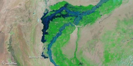
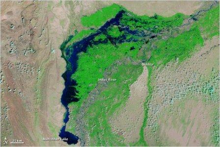
Posted on 27 Oct, 2010 11:09 AMNew satellite images from NASA show the extraordinary scope of the continuing disaster in Pakistan, where thousands of square miles of land remain submerged two months after the country was hit by catastrophic flooding.
 A satellite image captured last week shows flood waters lingering in Sindh Province and Manchhar Lake at twice its normal size.