Courses, Toolkits, Manuals, Guides and Handbooks
Why study weather – A presentation by ACWADAM
Posted on 12 Sep, 2010 11:03 AMThis presentation by ACWADAM deals with weather, the most fundamental process that shapes the earth. Meteorology, the science of studying weather, is described where some predictions can be made using atmospheric conditions or some data can be generated using simple equipments. These can in turn be used for measurement of weather for better implementation of a watershed project.
Type of rocks – A presentation by ACWADAM
Posted on 11 Sep, 2010 08:07 PMThis presentation by ACWADAM deals with the three basic types of rocks that are found in nature – igneous, sedimentary and metamorphic. Rocks are classified on the basis of minerals & chemical composition, by texture and by the processes that formed them.

Allocation of water charges for multi-housing communities in India: Sub-metering and ratio utility billing system (RUBS)
Posted on 10 Sep, 2010 01:35 PMOne of the most serious issues of water management is the question how to allocate the water resources to guarantee sufficient amount of water for all demands. That is why, it can be expected that allocation management will gain further importance in the future. It is not exaggerated to declare that “the issue of allocation overshadows all other aspects of water management”.
Community organisation in groundwater management – A presentation by ACWADAM
Posted on 27 Aug, 2010 04:01 PM This presentation by ACWADAM on community organization in groundwater management deals with the processes involved in people’s mobilization and participation. The requisites of groundwater management include: resource enhancement, demand management, equitable distribution, institutional mechanism and controlling of free riding. It deals with groundwater management at a local scale when compared to aquifer management.
Aquifer management involves:
- Identification of aquifer on the basis of geology;
- Identification of recharge and discharge areas;
- Assessment of aquifer capacity and yield through aquifer mapping;
- Protection of recharge area and increasing the groundwater level through artificial recharge in recharge area (based on the geology);
- Treating groundwater as a common property resource;
- Encouraging community use of groundwater and restricting individual use;
- Putting in place an institutional mechanism and legal back up for community groundwater management;
- Awareness generation regarding groundwater and science of hydrogeology.
Hydraulic conductivity: The ability of the rock material to allow the flow of groundwater – A presentation by ACWADAM
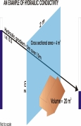
Posted on 27 Aug, 2010 08:10 AM This presentation by ACWADAM on hydraulic conductivity deals with the hydrologic properties of rocks that signify the status of a rock as a good or poor aquifer. The status of a rock with regard to groundwater occurrence and movement is decided by its porosity (specific yield, more practically) and its hydraulic conductivity. These properties decide whether a rock can store and transmit groundwater.
Hydraulic conductivity is also commonly called as permeability of the rock or rock material and is its ability to allow the flow of groundwater through it. A rock with good hydraulic conductivity allows groundwater to easily flow through it.
The presentation describes Darcy’s Apparatus, which comprises of a glass cylinder filled with porous sand. The glass cylinder with the sand bed had an inlet for inflow of water and an outlet for outflow of water. Two vertical glass tubes (manometers) are fitted in the sand tube placed at a fixed distance from each other to measure the respective levels (hydraulic heads).
Karst Hydrogeology – A presentation by ACWADAM
Posted on 27 Aug, 2010 12:42 AMThis presentation by ACWADAM deals with Karst hydrogeology, a term used to denote the topography over limestones, dolomites or gypsum rich rocks where there are sinkholes, caverns and lack of surface streams. Karst mainly refers to carbonate rocks: Limestones (CaCO3) or Dolomites (MgCa[CO]).
The formation of carbonate rocks can be traced to physical and chemical deposition. Physical deposition is clastic in nature formed by deposition of particles carried in suspension. It is marked by higher primary porosity and low secondary porosity. Chemical deposition is in the form of precipitate formed by deposition of particles from solution. Contrary to physical deposition it is marked by low primary porosity and high secondary porosity.

Points of groundwater discharge: Types of springs – A presentation by ACWADAM
Posted on 26 Aug, 2010 08:52 PMThis presentation by ACWADAM deals with springs, their characteristics and types. Springs are indicated by locations or points on the ground surface, where water from beneath the ground emerges on to the surface. A common example is of an overflowing unconfined aquifer.
Some of the characteristics of springs are:
- Discharge from spring may be constant or variable.
- Springs can be perennial or seasonal.
- Discharge from a spring may vary between from a trickle to about 100 cum per second.
- Difficulty in access.
- Variation in discharge.
- Temperature of spring water may vary from mean atmospheric temperature to lower or higher, even boiling temperatures. Hot quality water springs are common to many parts of the world.

Water for All - An educational booklet by Utthan
Posted on 25 Aug, 2010 10:32 AMThis document is an educational booklet on water management, published by Utthan, which works towards empowering women's groups to seek clean and adequate quality of water for all.
The booklet provides background information on water as an important natural resource and the importance of protecting and maintaining the quality and quantity of this natural resource.
The details have been explained in a manner that is simple and understandable and include illustrations that are self explanatory and easy to follow.
The booklet is divided into the following sections:
Seven Steps to Hygiene - An educational booklet by Utthan
Posted on 25 Aug, 2010 09:22 AMThis document is an educational booklet on sanitation and hygiene published by Utthan, which works towards empowering women's groups to seek clean and adequate quality of water for all.
The booklet includes the details of seven steps that can be undertaken to attain sanitation and hygiene. The details have been explained in a manner that is simple and understandable and includes illustrations that are self explanatory and easy to follow.
The seven steps include:
- Use and protection of water sources
- Managing drinking water
Pani Panchayat: A model of groundwater management – A presentation by ACWADAM
Posted on 25 Aug, 2010 08:20 AM The presentation by ACWADAM deals with Pani Panchayats as a model of groundwater management.
Pani Panchayat is the name first given to a movement by Mr. Vilasrao Salunke for motivating farmers of Naigaon village of the drought-prone Purandhar taluka of Maharashtra in 1974. The government's inability to deal with the drought situation prompted him to take a 40 acre land on lease from the village temple trust and develop a recharge pond in the recharge area of the village, a dug well in the discharge zone and a lift irrigation system.
Farmers got impressed with the results demanding a scale up of the experiment leading to the setting up of Gram Gaurav Pratisthan (GGP) through which the work was expanded to encompass both groundwater and surface water management.