Mahanadi
Man-made floods in Orissa in September 2011- Key issues raised by Water Initiatives Orissa
Posted on 06 Oct, 2011 10:24 AMOrissa was hit by two spates of flood in September 2011, the first one being caused by heavy rains in the Mahanadi catchment and release of huge discharges from Hirakud dam. The second one was caused by heavy rains and flooding of Brahmani, Baitarani and Budhabalanga rivers. These floods point to the loopholes in river basin planning and management and calls for urgent attention of planners and policy makers.
Different designs, same management: A note from Water Initiatives Odisha on Rengali dam and flood management
Posted on 28 Sep, 2011 09:57 AMWater Initiatives Odisha, brings out a special note on this issue in response to the latest spell of the flood disaster in northern Odisha Rivers.
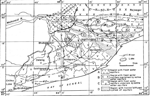
A study of saline freshwater interface phenomena in the Mahanadi delta region (Orissa)
Posted on 10 Jul, 2010 10:40 PM The subsurface aquifer systems in Mahanadi delta region in Orissa (India) is largely characterized by two groups of freshwater aquifer systems, both of which are prone to saline water mixing/migration with time and development:
- The south western Mahanadi delta region is represented by unconfined to semi-confined freshwater aquifers underlained by brackish/saline aquifer systems with a diffusion boundary.
- The north eastern parts of Mahanadi delta is represented by deep freshwater confined aquifers overlained by brackish/saline water aquifers with aquitard/ aquiclude boundary.
A study of saline freshwater interface phenomenon in the Mahanadi delta region, Orissa
Posted on 02 Jul, 2010 04:47 PMABSTRACT
Impact of climate change on the Mahanadi river basin
Posted on 28 Aug, 2009 02:56 PMThe Mahanadi River delta plain covers 0.9 x 10 km and lies between 85 40' : 86 45' E and 19 40' : 20 35' N. The catchment area of the river covers 1.42 x 10 km. The sediment yield of the Mahanadi catchment is around 200-400 tonnes/km. It has an average annual rainfall of 1572 mm and 70% of this during the SW monsoon season.
References of the impact of climate change on river deltas and other coastal areas
Posted on 26 Aug, 2009 04:48 PMMumbai Marooned: An Enquiry into Mumbai Floods 2005 - Final Report ,
By Conservation Action Trust - Click here
Enquiry-mumbai-floods-2005-final-report
Impact of climate change on river deltas and other coastal areas in India
Posted on 26 Aug, 2009 04:23 PMThe effects are most visible in the Sunderbans. Literally the 'beautiful forest', these wetlands at the mouths of the Ganga and Brahmaputra river systems are among the largest mangrove forests in the world. About 62% of this area of some10000sq km lies in Bangladesh but there is a significant Indian portion in the state of West Bengal.
Map: Location of water resource projects across river basins in India
Posted on 20 Aug, 2009 03:23 PMThe map indicates that across the main 19 river basins of the country, water resource projects with a total live storage of 174 BCM (Billion Cubic Metres) have been completed, 75 BCM are ongoing, and 132 BCM are being planned.
River basins and river basin organisations in South Asia
Posted on 22 Jul, 2009 03:12 PMAs part of the research study, River Basins and River Basin Organisations in South Asia, done by the Society for Participatory Development Hyderabad, CapNet South Asia (Read More) and Gomukh Environmental Trust for Sustainable Development Pune (Click Here), data about individual river basins has been collected for the river basins in South Asia.
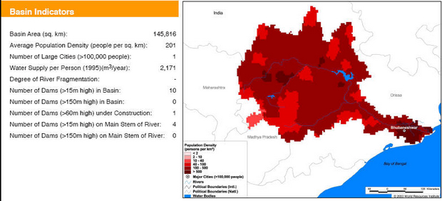
Basin maps of Mahanadi river showing basin indicators, landcover classes and biodiversity information and indicators
Posted on 17 Apr, 2009 02:07 PM
Basin indicators map of Mahanadi river basin