India
Groundwater balance – A presentation by ACWADAM
Posted on 21 Sep, 2010 10:00 PM This presentation by ACWADAM deals with the subject of groundwater balance. It begins by describing the skeleton for the water balance equation viz., ground surface, soil, aquifer and bed rock. It describes the processes subsequent to rainfall such as interception, initial detention, depression storage, infiltration, runoff, streamflow, soil moisture retention and recharge.
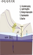
The watershed water balance equation is explained in terms of input (rainfall and water transfers) and output (runoff, evapotranspiration and infiltration). It notes that the input to a generalized water balance is rainfall whereas the input to a groundwater balance is infiltration. The difference between infiltration & recharge, natural & artificial recharge and interflow & discharge are explained thereafter. The water balance for an aquifer may vary, depending upon the nature of groundwater system –
- Watershed with a deep aquifer
- Watershed has both shallow and deep aquifers
- Watershed has only shallow aquifer
Geological mapping – A presentation by ACWADAM
Posted on 21 Sep, 2010 08:27 AMThis presentation by ACWADAM deals with geological mapping. The occurrence of water within a watershed is governed by the rock types occurring both at the surface and within the subsurface, their sequence and their structure. The physical structure which plays host to the water within the watershed is geological. Every watershed programme must therefore include a fundamental understanding of this framework so that the development and management measures planned through such programmes are meaningful and properly justified technically.
Remote sensing – A presentation by ACWADAM
Posted on 21 Sep, 2010 07:24 AMThese presentations by ACWADAM deal with the application of remote sensing and aerial photography techniques in groundwater management. Remote sensing is a technique by virtue of which information about an object, area or phenomenon is obtained with the help of a sensor on board a platform from distance without coming in contact with object, area or phenomenon.
Groundwater management: Conceptual framework – A presentation by ACWADAM
Posted on 20 Sep, 2010 08:36 PMThis presentation by ACWADAM deals with the conceptual framework of groundwater management.
Groundwater management under the climate change scenario in India – A presentation by ACWADAM
Posted on 20 Sep, 2010 08:17 AMThis presentation by ACWADAM deals with the issue of groundwater management under the climate change scenario in India. Climate change is a change in the statistical distribution of weather over periods of time that range from decades to millions of years. The causes are -variations in solar radiations, plate tectonics, volcanism and change in earths orbit & axis.
Aquifer properties – A presentation by ACWADAM
Posted on 20 Sep, 2010 07:37 AMThis presentation on aquifer properties by ACWADAM deals with the storage and transmission properties of aquifers. The two functions of an aquifer, accumulation of water (storage) and flow of water (transmission) are discussed. The permeability or hydraulic conductivity of the aquifer which allows water to flow towards the well is described.
Earth System: Interactions Part II – A presentation by ACWADAM
Posted on 20 Sep, 2010 06:43 AMThis presentation by ACWADAM on earth system deals with the interactions between the four elements that make up this system. The complexity of the earth system, in which spatial and temporal variability exists on a range of scales, requires that an organized scientific approach be developed for addressing the complex, interdisciplinary problems that exist.
Earth System: Introduction (Part I) - A presentation by ACWADAM
Posted on 19 Sep, 2010 07:00 PMThe presentation by ACWADAM on earth system deals with the four elements that make up this system. Earth science generally recognizes four spheres, the lithosphere, the hydrosphere, the atmosphere, and the biosphere; these correspond to rocks, water, air, and life. These four interdependent parts or the earth's spheres are described as:
- the lithosphere, which contains all of the cold, hard, solid rock of the planet's crust (surface), the hot semi-solid rock that lies underneath the crust, the hot liquid rock near the center of the planet, and the solid iron core (center) of the planet
- the hydrosphere, which contains all of the planet's solid, liquid, and gaseous water,
- the atmosphere, which contains all of the planet's air, and
- the biosphere, which contains all of the planet's living organisms.
Hydrologic properties of rocks – A presentation by ACWADAM
Posted on 19 Sep, 2010 06:22 PMThis presentation by ACWADAM deals with hydrologic properties of the rock framework in which groundwater occurs and through which it moves. In watershed programmes, it is necessary to develop a correct understanding of the storage and transmission of water within such channels because the shape of openings in a rock or sediment, their size, volume and interconnection play a vital part in the hydraulic characteristics of an aquifer.
Groundwater management protocols and pilot experiences – A presentation by ACWADAM
Posted on 19 Sep, 2010 05:09 PMThis presentation by ACWADAM deals with introducing groundwater management protocols for wells in different phases of groundwater use. These protocols include geo-hydrology in watershed development, protection of recharge areas, efficient well use, pump capacity regulation, distance with respect to drinking water well regulation, depth regulation in drinking water well, regulation of agricultural water use and groundwater management through sharing.