Andhra Pradesh
Morphometric analysis of Suddagedda basin - A research report by National Institute of Hydrology
Posted on 30 Jun, 2010 08:52 PMThe study, which is a part of the representative basin studies, attempts to do a morphometric analysis of the Suddagedda basin of Andhra Pradesh. The linear, areal and relief aspects pertaining to morphology are studied. In ungauged basins and basins with very little hydrological data, the study of geomorphologic characteristics is important as these can be related with the hydrological characteristics of the basin and thus provide a simple way to understand the hydrologic behavior of various basins.
Seasonal changes in groundwater hydrochemistry of Kakinada town - A research report by National Institute of Hydrology
Posted on 30 Jun, 2010 07:31 PMThe report deals with the results of a study on seasonal changes in groundwater hydrochemistry of Kakinada town of Andhra Pradesh. A total of 29 dug wells and 16 filter points were selected for assessing the hydrochemistry. The monthly groundwater levels measured form the wells indicated that they are different for wells located above and below the Mean Sea Level (MSL).
Space time distribution of rainfall in the catchment of Yeleru river downstream of Yeleswaram, AP - A research report by National Institute of Hydrology
Posted on 29 Jun, 2010 07:23 PMThe study attempts to do a space-time distribution of rainstorms associated with the tropical cyclones in the Bay of Bengal over a period of 20 years from 1976 to 1996.
The magnitude of peak flood and shape of the flood hydrograph depends not only on the magnitude of the total storm rainfall but also on its distribution in space and time. Improvements of the accuracy and timeliness of hydrological forecasting would thus largely depend on the prediction of rainfall distribution in space and time.
Development of data simulation model and irrigation schedules for Eastern Godavari delta (Andhra Pradesh) - A research report by National Institute of Hydrology
Posted on 28 Jun, 2010 11:45 PMThe study has been conducted to develop a data simulation model and irrigation schedules for the eastern Godavari delta irrigation system, Andhra Pradesh. It aims at analysis of various factors that influence the irrigation operations and development of appropriate mathematical models and associated computer programs.
Modeling at Vasishta-Godavari river mouth using FESWMS – A research report by National Institute of Hydrology
Posted on 28 Jun, 2010 10:54 PMThe study attempts to undertake surface modeling to simulate the water levels in the mouth portion of Vasishta-Godavari by taking the tidal effect during a flood season, by using the Finite Element Surface Water Modeling System (FESMWS) developed by United States Geological Survey (USGS) to model the reach. The objective is to simulate the surface water flow for a flood discharge of 2.35 lakh cusecs, under the effect of diurnal tide at the bay end.
The surface water levels of a river, especially at the mouth are required for planning and managing flood alleviation schemes and river engineering works. In the lower reaches of many rivers, flood plain inundation may result from very high tide or a very high flood or a combination of both. Also the extent of landward intrusion of saline water into a river at mouth varies with the relative strength of freshwater discharge and the co-oscillating tidal flow resulting from the dynamical interaction of the adjacent coastal waters.
Changes in land use and land cover and establishment of SCS runoff Curve Number in Suddagedda basin – A research report by National Institute of Hydrology
Posted on 24 Jun, 2010 11:52 PMThe study was taken up as a part of the representative basin studies being done by NIH and involved hydrological land use & land cover mapping for the Suddagedda basin of Andhra Pradesh. Mapping was carried out through visual interpretation for the years December 1987, April 1989, December 1992 and November 1996 using IRS IB-LISS II, LANDSAT 5-TM and IRS IC-LISS III data.
Land use and land cover are the most important surface characteristics of a basin. They are very dynamic features over space and time and it is difficult to get real time information on them through conventional means. Planners need to update knowledge of natural resources, which can be obtained quickly, economically and accurately through remote sensing techniques. Further, the land use map of a basin or region provides hydrologically significant categories, which are essential for estimation of reliable runoff from ungauged basins.
Hydrological soil classification of Suddagedda basin - A research report by National Institute of Hydrology
Posted on 24 Jun, 2010 11:27 PMThe study undertakes hydrological soil classification of Suddagedda basin of Andhra Pradesh based on field and laboratory experiments on the soil samples. The hydrologic soil properties of an area are essential to accurately estimate the runoff generated due to storm in the area. The main soil parameters generally considered for analysis are soil texture, soil structure, infiltration rate and hydraulic conductivity.
Daily rainfall-runoff modeling for Gundlakamma basin of Andhra Pradesh – A research report by National Institute of Hydrology
Posted on 22 Jun, 2010 05:20 PMThe study applies a simple five-parameter model based on the concept of probability distributed method as proposed by Moore (1985) to simulate the daily runoff over a nine-year period of 1989-1997 at Tamavaram in Prakasham district of Andhra Pradesh on the Gundlakamma river.
Spatial evaluation of groundwater levels and its quality in Kakinada town (Andhra Pradesh) - A research report by National Institute of Hydrology
Posted on 22 Jun, 2010 04:11 PMThe study presents the spatial analysis of groundwater levels and its quality for the year 1998 for Kakinada town in coastal Andhra Pradesh. The Deltaic Regional Centre of NIH has been monitoring groundwater levels and its quality in and around Kakinada town since 1994. Groundwater samples have been analyzed for physical and chemical parameters. The variation in each parameter is discussed in the report.
A total of 164 samples were collected from 41 observation wells during the months of February, May, August and November 1998. The area covered by these observation wells is around 82 sqkms. The groundwater table contours were plotted for pre-monsoon (May 98) and post monsoon (November 98) periods and the approximate flow direction had been demarcated.
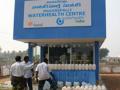
Clean drinking water using low-cost purification plants - A case study from the work of IFMR Trust and WaterHealth India in Andhra Pradesh
Posted on 08 Jun, 2010 11:49 PMThis field report describes the work of WaterHealth India (WHI), in organising safe drinking water using low-cost water purification units, in several villages of Andhra Pradesh. The work was taken up with financial support from IFMR Trust.
Vinjinampadu village in Guntur district, Andhra Pradesh, is one of the villages where WHI worked to establish the unit. The village had lacked potable water supply, because of which its people suffered from a range of water-borne diseases. The situation was similar in many of the other villages in which WHI initiated this work.