The work is divided into the following chapters:
Overview
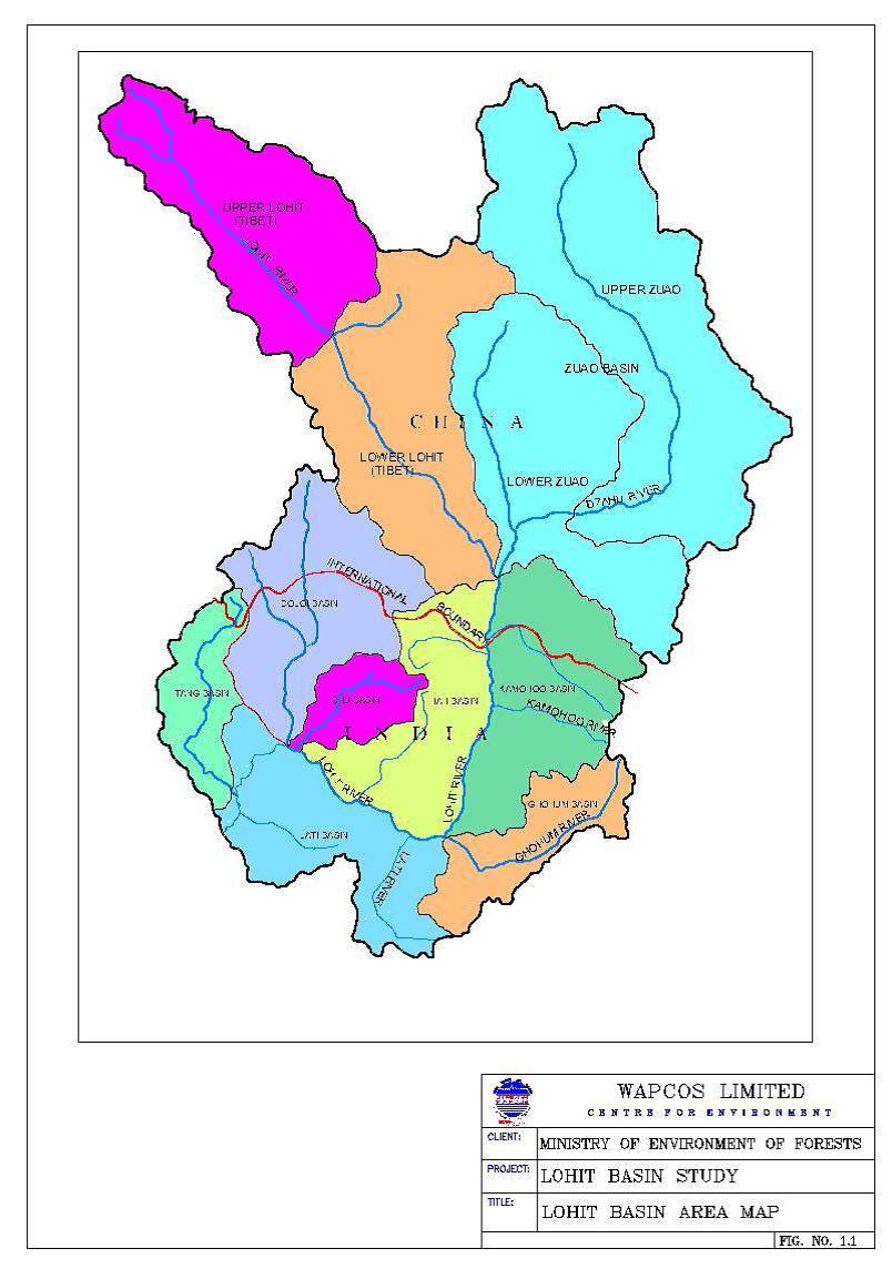
Chapter-1 begins with an overview of the concept of a basin study, emphasizing that it is an integrated approach to assessing the impacts of various interventions. This is followed by a brief description of the study area, planned projects in the area and the status of environmental clearance of these projects. It needs to be emphasized here the despite being a basin study, only the projects on the main stream are considered. This is followed by information about the area, geology, physiography, seismic vulnerability, the tributaries of the Lohit.
Description of projects proposed on the Lohit
Chapter-2 includes description of the following projects proposed to be developed on the river Lohit:
- Kalai hydroelectric project stage-1
- Kalai hydroelectric project stage-2
- Hutong hydroelectric project stage-1
- Hutong hydroelectric project stage-2
- Demwe Upper hydroelectric project
- Demwe Lower hydroelectric project
Construction details, costs and layout plans are included in this description.
Methodology adopted for the study
Chapter-3 outlines the methodology adopted for conducting the basin study. Data available in the preliminary feasibility reports (PFR) and detailed project reports (DPR) of various projects provided by the project developers, data from IMD, and from the forest department have been sourced. Primary surveys have also been carried out for water quality, terrestial ecology, and aquatic ecology.
Hydrological aspects of Lohit basin
Chapter-4 presents information on hydrological aspects of Lohit river Basin. Discharge data has been compiled and flow duration curves developed for the various sites.
Water quality surveys
Chapter-5 covers the results of the water quality surveys conducted monthly at the different sites. The quality at all the sites is excellent with anthropogenic contaminants (phenolic compounds, oil and grease, coliform bacteria) being below determinable levels. This indicates the pristine nature of the basin.
Aquatic ecological aspects
Chapter-6 presents the aquatic ecological aspects of environment. The data presented in this chapter are based on primary as well as secondary data sources. The high aquatic biodiversity including the presence of several endangered and vulnerable species is testament to the ecological importance of the area. This includes many migratory fish species, which will be severely endangered by any dam construction. The report itself acknowledges the catastrophic effect of dam construction on the migration and spawning of this species. Shortly after, it states that 'total fish community will not be wiped out or totally disturbed because of dams'.
Terrestial ecological survey
Chapter-7 presents the findings the terrestrial ecological survey conducted for two seasons as a part of the study as well as secondary data. The following forest types are found in the basin:
- Tropical semi-evergreen forest
- Tropical secondary forest
- Plantation forests
- Montane sub-tropical wet hill forest
- East Himalayan sub-tropical pine forest
- East Himalayan wet lower temperate forest
- East Himalayan wet temperate forest
- East Himalayan coniferous forest
The results of the surveys indicate high biodiversity including several rare and endangered species among both plants and animals (including birds, mammals, amphibians and reptiles).
Impact of project activities
Chapter-8 attempts to predict the impact of project activities using mathematical models and qualitative assessment. The impact of dam construction on flow regime, free-flowing river stretch, fisheries and flora are discussed. However, the severity of these impacts are minimised by:
- not considering the cumulative nature of the various modifications
- assuming, in the analysis of the impacts, that these will be mitigated by the environmental management plan
Environmental flows
Chapter-9 discusses the environmental flow regime required by the basin. It begins with an overview of the various methods available, and then presents the environmental flow requirements using the Tennant method, Hughes and Munster method, and the index method. However, there are serious issues with the assumptions made in the selection of various parameters for this flow assessment. These are dealt with in detail by SANDRP and can be accessed here.
Environmental Management Plan
Chapter-10 suggests an Environmental Management Plan (EMP) for the amelioration of anticipated adverse impacts. Here, in spite of the earlier chapter that details the concept of an environmental flow regime, a 'minimum flow' is again discussed. The natural fish habitats are proposed to be replaced by government run hatcheries.
The plan emphasises that of the 144.4 km river, only 42.4 km will remain under what it calls 'free flowing conditions'. However, this 42.4 km is in 5 stretches that range between 1 to 3.8 km, with the exception of a 32 km stretch at the international boundary. A river flowing in stretches of an average of 2.08 km (excluding the first stretch) cannot be considered to be free flowing under any circumstances.
In addition, it attempts to white-wash the catastrophic effects of dam construction in such a pristine area by working on the assumption that the environmental management plan will reverse the impacts. The effect of dam construction on the tributaries and on local tribal communities are not considered. The effect of dam-related construction such as roads and housing colonies are also not considered.
Conclusion
This cumulative impact assessment is in need of improvement. It is also the first among many that will likely be commissioned in the future, given the dialogue about hydro-power development in the country.
Your comments invited
We invite your comments on both this basin assessment plan, and ways to ensure that any future plans are true to the intent as well as the letter of their commissioning. Please give us your suggestions in the comments section below.
Other relevant references
SANDRP comments on the Lohit basin assessment
Effect of peaking report on Dibru Saikhowa National Park - Ministry of Environment and Forests
SANDRP comments on the 'Effect of peaking on Dibru Saikhowa National Park'
SANDRP comments on the site assessment report for Dibru Saikhowa and Lower Demwe