Surface Water

Featured Articles
October 11, 2022 In an effort to inform the general public, especially citizen activists, policymakers, researchers, and students, about the current status of the Vrishabhavathi river, Paani.Earth has created the necessary maps, data, analysis, and information to drive conservation awareness and action around the river.
Vrishabhavathi river (Image Source: Paani.Earth)
August 9, 2022 Ensuring irrigation through farm ponds in tribal Chhattisgarh
Many tribal farmers opted for individual farm ponds under MGNREGA ensuring protective irrigation. (Image: Meenakshi Singh)
November 8, 2020 The National Hydrology Project has created a national platform for water data and is working to enhance the technical capacities of agencies dealing with water resources management.
Breakthrough cloud computing facilities and remote sensing applications have helped showthe filling pattern of a water body (tank or reservoir) through freely available satellite imagery at an interval of five days.  (Image: Maithan dam, Wikimedia Commons)
December 26, 2019 Policy matters this week
The Mandovi river disputed between Karnataka and Goa (Source: IWP Flickr Photos)
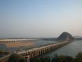
Godavari, Krishna rivers are interlinked
News this week Posted on 14 Sep, 2015 10:21 PM

Godavari, Krishna rivers interlinked

Prakasam Barrage across Krishna river (Source: Subhash Chandra via Wikipedia)
Long-delayed Teesta-III project in Sikkim gets cleared
Policy matters this week Posted on 14 Sep, 2015 08:26 PM

Teesta-III project in Sikkim gets a green signal

The meandering Teesta river (Source: IWP Flickr Photos)
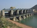
Bisalpur revisited--10 years after protesters were shot, killing 5
Despite many plans, neither rural nor urban are water secure thanks to the Bisalpur Dam since it was constructed in 2007. Posted on 10 Sep, 2015 01:20 PM

Ten years ago five farmers were shot protesting the diversion of waters from Bisalpur dam to Jaipur city, located about 130 kms away.

Kisan Sewa Samiti, Chaksu struggling for drinking water allocation from Bisalpur dam (Source: CECODECON)
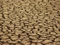
2015 is India's driest year since 2009
News this week Posted on 07 Sep, 2015 10:19 PM

40% of India still rain deficit

Parched area near Jodhpur (Source: India Water Portal Flickr Photos)
No more dam approvals until e-flow report is out: Water Ministry
Policy matters this week Posted on 07 Sep, 2015 09:35 PM

No approval of dams until e-flow report is out: Water Ministry to CWC

Kelo dam near Raigarh (Source: India Water Portal Flickr Photos)
Access to water data: Implications for transboundary relations in the Ganges river basin
Despite the enactments of RTI laws and insistence for openness in the government, access to information regimes on transboundary rivers has not changed at a fundamental level in South Asia. Posted on 05 Sep, 2015 12:21 PM

Citizens right to access information on water, climate and environmental issues

A view of the Sharada river at Lucknow, Uttar Pradesh (Source: Wikimedia Commons)
Sunderbans and Siachen glacier to become trans-boundary protected area
Policy matters this week Posted on 31 Aug, 2015 10:25 PM

Sunderbans and Siachen glacier proposed to be recognised as a trans-boundary protected area

Farm fields in the Sunderbans (Source: India Water Portal Flickr Photo)
India's groundwater: Invisible water, visible crisis
News this week Posted on 31 Aug, 2015 06:13 PM

Massive national effort needed to resolve India's depleting groundwater

Water well in Purulia, West Bengal (Source: India Water Portal Flickr Photos)
Kaun kitne paani mein: Movie review
A Hindi film set in a water starved locale in Odisha asks, "Can water be bartered for love?" Posted on 28 Aug, 2015 06:45 PM

Kitna shaant hai ye paani, aur iske liye yeh rajniti’ (the water is so still, yet there is politics around it).

Water scarcity becomes a source of conflict between two villages (Source: Facebook)
Training Programme on Introduction to SWAT by IIT Madras
IIT Madras is organising a short-term training programme on 'Introduction to Soil and Water Assessment Tool (SWAT)' using open source tools- QGIS and QSWAT
Posted on 25 Aug, 2015 04:03 PM

The primary objective of this short term training program is to provide college teachers and professional engineers with a comprehensive understanding of GIS techniques relevant for studies related to water resources assessment.

×