Surface Water


Influence of anthropogenic contamination on fluoride concentration in groundwater: A study of Mulbagal town, Kolar district, Karnataka
Posted on 15 Feb, 2013 04:53 PMGroundwater contamination is a serious, but relatively ignored issue in the country. This contamination occurs in either through geogenic or anthropogenic means. Fluoride contamination is one such example of geogenic contamination that is widely found in the Kolar district of Karnataka. However, the fluoride levels in the town of Mulbagal are lower than those in the surroundings. Earlier, a study was conducted on the impact of pit toilets on the groundwater in the area. The present paper investigates the presence of any link between these two phenomena.
Handbook for flood protection, anti-erosion and river training works by Central Water Commission (2012)
Posted on 13 Feb, 2013 09:43 PMThis handbook by Central Water Commission aims to provide necessary guidance to the field engineers in the state and central for design, appraisal, construction and monitoring of the flood management works covering all the relevant BIS codes, design manuals, guidelines, technical specifications for construction materials and practices etc. to meet new challenges in the flood management in India.
Book review: Governing international watercourses by Susanne Schmeier
Posted on 13 Feb, 2013 04:45 PMThis article presents a review of the book 'Governing international watercourses' by Susanne Schmeier - a book that has been called 'a stunning piece of work' by Aaron T. Wolf. The author examines the river basin organisation as a key institution for managing international watercourses. The book follows a three-part structure of developing theory, refining it, and then discussing three case studies. By emphasizing that more trans-boundary events are focused on cooperation rather than on conflict- with a far smaller percentage being violent conflict - it carries a message of hope.
Living rivers, dying rivers: Everything you wanted to know about rivers in India
Posted on 13 Feb, 2013 10:41 AMIn an attempt to join crucial debates surrounding the alarming increase in environmental degradation, especially of rivers and river systems, Prof. Ramaswamy Iyer, India’s foremost expert in the field conceived and carried forward a series of talks titled ‘Living Rivers, Dying Rivers’ with support of India International Centre.
Videos: Resurgence of the ahar pynes - Magadh Jal Jamaat helps revive 2000-year old flood water harvesting systems in Gaya, Bihar
Posted on 13 Feb, 2013 10:34 AMMagadh Jal Jamaat, a loose network of progressive individuals in Gaya has been successfully able to revive over a dozen abandoned water sources and have instilled in people the need to create, clean up and conserve several lakes and ponds in the region.
An exhibition at Studio Safdar in Shadi Khampur traces the history of the urban village and its water systems
Posted on 10 Feb, 2013 07:12 PMGuest post: Amita Bhaduri
West Delhi’s dusty neighbourhood, Shadi Khampur now has its own museum, in the traditional brick-and-mortar sense. I live nearby, have worked out of an office here and am familiar with the alleyways. But I got to know only now, what life in the neighbourhood was like. Its rich history and its connect to larger narratives from the past, like the series of land acquisitions in Delhi, the Emergency, and the anti-Sikh riots of 1984 which had gone largely undocumented and unarchived have been chronicled in the Neighbourhood Museum of Local History of Shadi Khampur, at Studio Safdar, a cafe cum bookstore.

Neighbourhood Museum at Studio Safdar
Source: Facebook page on “Public Art Project at Studio Safdar”
River basin atlas of India – A report by Central Water Commission and Indian Space Research Organisation
Posted on 10 Feb, 2013 01:12 PMThis publication by the Central Water Commission (CWC) and Regional Remote Sensing Centre – West, Indian Space Research Organisation (ISRO) presents the status of water resources development in each of the river basins as per CWC classification. It was launched on November 1, 2012 by Minister of Water Resources Shri. Harish Rawat in a function organized at CWC, New Delhi.
This comprehensive publication gives detailed information of major water resources projects along with the location of all hydrological observation sites including major dams, barrages etc. in all the river basins of India.
This "River basin atlas of India", an outcome of joint project “Generation of Database and implementation of web enabled Water Resources Information System (India-WRIS) in the country”, is a publication by the Central Water Commission (CWC) and Regional Remote Sensing Centre – West, Indian Space Research Organisation (ISRO) that presents the status of water resources development in each of the river basins as per CWC classification. It was launched on November 1, 2012 by Minister of Water Resources Shri. Harish Rawat in a function organized at CWC, New Delhi.
This comprehensive publication gives detailed information of major water resources projects along with the location of all hydrological observation sites including major dams, barrages etc. in all the river basins of India. All these features have been portrayed on the maps with river network, major cities and terrain in background. The hydrological and Flood Forecasting observation sites of Central Water Commissions are also marked in the basin maps.
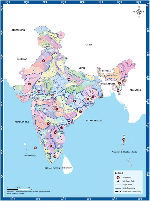
India-WRIS Sub-basins, Source: River basin atlas of India, CWC and ISRO, 2012
Performance of expert appraisal committee for river valley and hydroelectric projects from 2006-2012 - Analysis by South Asia Network on Dams, Rivers and People
Posted on 07 Feb, 2013 12:58 PMWhile developmental projects are beneficial for growth of an economy they do have negative impact on the environment. This impact varies significantly by project type, size and location. In order to identify, examine, assess and evaluate the probable impacts of a proposed project on the environment the Ministry of Environment & Forest (MoEF) in 2006, constituted different committees. The committees are called as Expert Appraisal Committees (EAC). An EAC committee on River Valley & Hydroelectric projects was also set up on these lines. In the backdrop this South Asia Network on Dams, Rivers and People (SANDARP) an informal network of organisation and individuals working on water issues has come up with an analysis on how have this committee performed till now? This document presents an analysis of the same.
Assessing the environmental flows for Kumbh Mela- 2013 at Triveni Sangam, Allahabad, Uttar Pradesh- A document by World Wildlife Fund India
Posted on 04 Feb, 2013 03:49 PMThis document by the World Wildlife Fund India, is on the rapid assessment done on the Environmental Flows(E-Flows) for Kumbh Mela that is taking place in Allahabad, Uttar Pradesh.
The sorry state of Mikkere lake in Malavalli taluk in Karnataka: Photographs by Jaraganhalli Kantharaju
Posted on 31 Jan, 2013 06:34 PMJaraganhalli Kantharaju shares with us the sorry state of Mikkere lake in Malavalli taluk of Mandya district in Karnataka which is in need of immediate attention and restoration.