Surface Water

Featured Articles
October 11, 2022 In an effort to inform the general public, especially citizen activists, policymakers, researchers, and students, about the current status of the Vrishabhavathi river, Paani.Earth has created the necessary maps, data, analysis, and information to drive conservation awareness and action around the river.
Vrishabhavathi river (Image Source: Paani.Earth)
August 9, 2022 Ensuring irrigation through farm ponds in tribal Chhattisgarh
Many tribal farmers opted for individual farm ponds under MGNREGA ensuring protective irrigation. (Image: Meenakshi Singh)
November 8, 2020 The National Hydrology Project has created a national platform for water data and is working to enhance the technical capacities of agencies dealing with water resources management.
Breakthrough cloud computing facilities and remote sensing applications have helped showthe filling pattern of a water body (tank or reservoir) through freely available satellite imagery at an interval of five days.  (Image: Maithan dam, Wikimedia Commons)
December 26, 2019 Policy matters this week
The Mandovi river disputed between Karnataka and Goa (Source: IWP Flickr Photos)
Invite to a workshop on 'Wetlands of Assam', Aaranyak and IUCN-India, Guwahati
The focus of the workshop will be hydrological connectivity, climate change, ecosystem services and livelihoods with reference to Deepar Beel, Kamrup (Metro) District, Assam.
Posted on 29 Jan, 2014 04:56 PM

Purpose: 

(i) Take stock of the conservation and management status of the wetlands of Assam in general

(ii) Discuss the significance of good landscape connectivity of flood plain wetlands

(iii) Share the framework and results of Aaranyak-IUCN study on the Deepar beel on wetland connectivity and modelling

Bird sanctuary Chilika designated 'Destination Flyways'
News this week: UN to develop strategies to protect migratory birds in Chilika, Odisha; Cochin estuary has highest in toxicity in the world; Jaipur farmers in conflict with bottling plant. Posted on 29 Jan, 2014 12:29 PM

Chilika lagoon named as 'Destination Flyways' by UN

Chilika bird sanctuary, Odisha (Source:Aditi Pany)
Power corridors for each river basin in Himachal
Policy matters this week: Expert team moots plan to develop power corridors for each basin; Maharashtra govt to make drip irrigation a must for cash crops; DJB to formulate policy to treat greywater. Posted on 29 Jan, 2014 12:28 PM

Plans to create power corridors for each river basin on its way

Hydropower transmission (Source: Wikipedia)
Mapping land and water resources in India
With rare maps of India including 'Annual Rainfall' map, 'Water Balance' map and 'Land Use' map, the land and the water resource development atlases are excellent sources of information. Posted on 27 Jan, 2014 01:18 PM

India’s mapping activity dates back to the Indus Valley Civilization (c. 2500–1900 BCE) as per the famous geographer, Joseph E. Schwartzberg. His work is based on a couple of surveying instruments and measuring rods that were excavated from the Indus valley sites. Our mapping traditions were influenced by Vedic, Tibetan, Islamic and more recently, British cartography.

Water resources development in Gujarat (NATMO)
A farmer's bonus
Elumalai in Kanchipuram, Tamil Nadu, grows paddy crops and rears poultry, goat and fish. He even keeps bees! Thanks to being smart and profitable, he's popular as well as an inspiration to locals. Posted on 27 Jan, 2014 11:53 AM

Farmer Elumalai looks on at his pond
Ministry eases green norms for coal mine expansion
Policy matters this week: MoEF eases green norms for expanding coal mines; government to undertake review of existing water-related laws; site visit becomes mandatory before forest land diversion. Posted on 21 Jan, 2014 03:31 PM

Green norms eased for expanding coal mines

An open cast mine (Source: Garavi Gujarat)
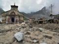
Channel Mandakini to its original course: GSI
News this week: GSI recommends channeling Mandakini river to its original course; Sohra experiences one of the driest year; HC orders close down of 12 units in Mundra SEZ, Gujarat. Posted on 21 Jan, 2014 03:29 PM

GSI report suggests channeling Mandakini river

Uttarakhand floods (Source: The Hindu)
Which way will the water flow?
The 12th Five Year Plan recognises that our current methods of water management have led to inequity. It suggests an approach that involves more input from non-government sources. Posted on 15 Jan, 2014 11:07 PM

In the 60-odd years since we began managing our own resources, we have managed to throttle and poison all our rivers, suck our groundwater resources nearly dry and shave our forests bald. This is despite a great deal of effort, time, thought and resources that have gone into this 'management'.

Ramaswamy Iyer, former Secretary Water Resources
Improved sanitation can reduce diarrhoea cases by 47%
Policy matters this week: Diarrhoea cases can come down with improved sanitation, SC tells Centre to appoint Regulator for environment matters and new water scheme for rural areas. Posted on 14 Jan, 2014 06:41 PM

Improved sanitation can reduce diarrhoea cases by 47%: World Bank

Sanitation means good health (www.thinkaboutit.eu)
Big steel firms illegally mined Rs. 45,000 Cr worth
News this week: Commission finds that big corporates mined Rs. 45000 Cr worth iron ore, Delhi residents protest waste incinerator and POSCO's clearance to be revalidated. Posted on 14 Jan, 2014 06:40 PM

Corporates like Tata Steel, Essel Mining violate green laws in Odisha

Illegal Ironore mining in Odisha (Indialatest.org)
×