Governance

Featured Articles
November 6, 2022 In 2020, 559 million children were affected by four to five heatwaves a year; numbers could increase four-fold by 2050, as per a report by UNICEF
Heat-related mortality is four times higher among children under 1 year of age than in persons aged 1–44 years (Image: Taqver, Wikimedia Commons)
October 22, 2022 Role of MGNREGA in the year after the 2020 lockdown: Survey findings from Bihar, Karnataka, Maharashtra, and Madhya Pradesh
MGNREGA provided income support or security to vulnerable households during the pandemic (Image: UN Women)
October 14, 2022 Arthan organizes a fireside chat to highlight the need for more data talent for social impact
There is a need to integrate data science into the existing education system (Image: Mohamed Mahmoud Hassan, Public Domain Pictures)
September 9, 2022 Highlights from a new report released by iFOREST
An old coal-fired power plant has been dumping vast quantities of ash out in the open for many years. (Image: Lundrim Aliu/ World Bank; CC BY-NC-ND 2.0)
July 14, 2022 The river is faced with the dual problem of flood plain encroachment and growing levels of water pollution
Illegal transverse check dams (Badhals) built on Ichamati near a village in Basirhat (Image: Prithviraj Nath @ TheWaterChronicles)
July 10, 2022 People in India fleeing disasters like drought more likely to have experienced trafficking or modern slavery than those fleeing floods or cyclones
The country's climate change assessment suggests things are only going to get worse (Image: Saurav Karmakar, India Water Portal Flickr)
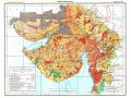
Mapping land and water resources in India
With rare maps of India including 'Annual Rainfall' map, 'Water Balance' map and 'Land Use' map, the land and the water resource development atlases are excellent sources of information. Posted on 27 Jan, 2014 01:18 PM

India’s mapping activity dates back to the Indus Valley Civilization (c. 2500–1900 BCE) as per the famous geographer, Joseph E. Schwartzberg. His work is based on a couple of surveying instruments and measuring rods that were excavated from the Indus valley sites. Our mapping traditions were influenced by Vedic, Tibetan, Islamic and more recently, British cartography.

Water resources development in Gujarat (NATMO)
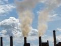
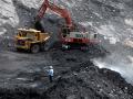
Ministry eases green norms for coal mine expansion
Policy matters this week: MoEF eases green norms for expanding coal mines; government to undertake review of existing water-related laws; site visit becomes mandatory before forest land diversion. Posted on 21 Jan, 2014 03:31 PM

Green norms eased for expanding coal mines

An open cast mine (Source: Garavi Gujarat)
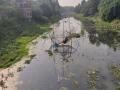
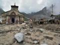
Channel Mandakini to its original course: GSI
News this week: GSI recommends channeling Mandakini river to its original course; Sohra experiences one of the driest year; HC orders close down of 12 units in Mundra SEZ, Gujarat. Posted on 21 Jan, 2014 03:29 PM

GSI report suggests channeling Mandakini river

Uttarakhand floods (Source: The Hindu)
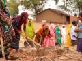
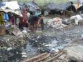
More people power equals more progress
Cuttack, in Odisha, overcame the bane of open defecation, dirty water and unclean surroundings thanks to participation and involvement by the locals. The 'Silver City' is now truer to its name. Posted on 20 Jan, 2014 09:42 AM

Clean surroundings, clean water and a clean toilet – as much as Cuttack, in Odisha is a thriving centre of trade and commerce, it lacked these three basic necessities. An exploratory survey was conducted in 2009 to understand why the city hadn't reached a better state of cleanliness.

Community based management (Source: NFI)
Pesticide 'thali'
A 2010 study by Consumer Voice found that Delhi's fruits and vegetables contain high levels of pesticide residue. Despite the high court getting involved, not much has changed since. Posted on 20 Jan, 2014 09:39 AM

One doesn't have to look far to find pesticide contamination in food and water in India.

Toxins are used as ripening agents in vegetables
No 'paani' for the 'aam aadmi'?
The Delhi government has promised free water for those with piped, metered connections in the city, up to a certain level of usage. Is this new scheme sustainable and equitable? Posted on 17 Jan, 2014 12:50 AM

As one of his first orders of business, Delhi's Chief Minister Arvind Kejriwal has announced a new water policy for Delhi-ites.

Water coming soon
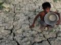
Which way will the water flow?
The 12th Five Year Plan recognises that our current methods of water management have led to inequity. It suggests an approach that involves more input from non-government sources. Posted on 15 Jan, 2014 11:07 PM

In the 60-odd years since we began managing our own resources, we have managed to throttle and poison all our rivers, suck our groundwater resources nearly dry and shave our forests bald. This is despite a great deal of effort, time, thought and resources that have gone into this 'management'.

Ramaswamy Iyer, former Secretary Water Resources
Improved sanitation can reduce diarrhoea cases by 47%
Policy matters this week: Diarrhoea cases can come down with improved sanitation, SC tells Centre to appoint Regulator for environment matters and new water scheme for rural areas. Posted on 14 Jan, 2014 06:41 PM

Improved sanitation can reduce diarrhoea cases by 47%: World Bank

Sanitation means good health (www.thinkaboutit.eu)
Big steel firms illegally mined Rs. 45,000 Cr worth
News this week: Commission finds that big corporates mined Rs. 45000 Cr worth iron ore, Delhi residents protest waste incinerator and POSCO's clearance to be revalidated. Posted on 14 Jan, 2014 06:40 PM

Corporates like Tata Steel, Essel Mining violate green laws in Odisha

Illegal Ironore mining in Odisha (Indialatest.org)
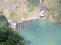
Sikkim's citizens say NO! to dams
90% of people living around dams in Sikkim testify to environmental damage, increased hazards and decreased resources. Can their situation be changed? Posted on 13 Jan, 2014 02:18 PM

Hydropower is considered as 'green' power and the Sikkim Government's policy has been to synchronize development imperatives with conscious efforts on environment sustainability. This paper presents the results of a survey carried out among communities living along a 54-km long project affected stretch of the Teesta river.

Dams intensify the impact of earthquakes
×