Droughts and Floods


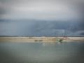

India must prepare for future growth by planning a low-water economy - Article in YaleGlobal Online by Rohini Nilekani
Posted on 19 Jul, 2011 12:37 PMArticle and Image courtesy: YaleGlobal Online
Author: Rohini Nilekani
India and China account for one third of the world’s population; each consumes more freshwater than other nations. Per inhabitant per year, though, India uses less than half what’s used in the US, China uses less than one third. This YaleGlobal series examines India and China’s water use, their expectations for rising demand and recognition that shortages will disrupt economic progress.
The Planning Commission of India repeatedly warns that water will become a more serious issue than land or energy for India in years to come, points out Rohini Nilekani, in the second article of the series. India’s transition from an economy based on agriculture to a mixed one, with water use controlled by states rather than the federal constitution, already leads to conflicts. She urges planning for a low-water economy. Good governance and regulatory frameworks can prevent pollution and waste, while encouraging efficiency, reliable and fair allocation, and wise consumer choices.
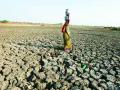
 Thirsty earth: Indian villagers in Gujarat gather to draw water from a well
Threat of land subsidence in and around Kolkata City and East Kolkata Wetlands – A paper in Journal of Earth System Science
Posted on 18 Jul, 2011 07:33 PMThis paper in Journal of Earth System Science attempts to estimate the possible rate of land subsidence of Kolkata City including Salt Lake City and the adjoining East Kolkata Wetlands located at the lower part of the deltaic alluvial plain of South Bengal basin. Land subsidence is an environmental hazard which is caused by overdraft of groundwater or oil extraction and results in gradual settling or sudden sinking of the earth’s surface owing to subsurface movement of the materials of the earth.
Geomorphic study for regeneration of aquatic ecosystem in Bareilly – An article in Geospatial World
Posted on 17 Jul, 2011 10:53 AMIt indicates that the aquatic ecosystem of an area disappeared due to unplanned development of agro ecosystems and human settlements. This area was earlier covered with ponds, wetlands and ox-bow lakes. Now, during the rainy season, inhabitants of these wards face severe problem of water logging and pollution.
Floods and heavy downpour in West Bengal in June 2011 - A rapid assessment report by Oxfam and Save The Children
Posted on 12 Jul, 2011 02:23 PMArticle courtesy: Corporate Disaster Resource Network
Assessment team:
Oxfam India – Mr. Pradeep Bharwad (Technical Assistance), Mr. Bhaswar Banerjee, Mr. Amit Sengupta
Save the Children - Mr. Abinash Lahkar, Mr. Piyush Kumar
Kajla Jana Kalyan Samity - Tapas Jana and Dipak Banerjee
Areas assessed: Moyna & Panskura Block of East Midnapore District of West Bengal
Assessment date: 24th June, 2011
Analysing the role of geomorphic features in Kosi flood – An article in Geospatial World
Posted on 12 Jul, 2011 10:45 AMKosi is known as the sorrow of Bihar due to its frequent and often disastrous floods. The major geomorphic units of flood-inundated area in Kosi fan (terrain of Kosi river in India) are sand bars in the form of inter-connected drainage networks, an ox-bow lake and its meandering cut-off and imprint.
Bracing for flood hazards : A commentary in Current Science
Posted on 09 Jul, 2011 07:22 PMClimate modeling studies indicate that there will be more spells of intense rainfall and frequent instances of extreme rainfall. This prediction is coming true, particularly in the central sector of the Himalayan belt, where there is pronounced decline in winter precipitation (both rain and snow) and prolonged spells of drought in summer broken by cloudbursts in localized areas.
Low carbon strategies for inclusive growth - An interim report of the Planning Commission's expert group
Posted on 28 Jun, 2011 11:44 PM Some policy measures implied by various options have also been indicated. The main sectors examined in the report are power, transport, industry, buildings and forestry.
Increased concentrations of Green House Gases (GHGs) and the overall warming of the atmosphere has resulted in changing rainfall patterns, disruption in hydrological cycles, melting of ice caps and glaciers, rise in sea levels, and increase in frequency and intensity of extreme events such as heavy precipitation and cyclonic activities.
These have in turn had serious impact on sustainability of water resources, agriculture, forests and ecosystems, affecting the well being of billions of people on earth. Widespread melting of glaciers and snow cover will reduce melt water from major mountain ranges (e.g. Hindu Kush, Himalaya, Andes) where more than one billion people currently live.
Release of the latest issue of The Hindu's annual publication - Survey of Indian Agriculture 2010
Posted on 27 Jun, 2011 12:41 PM The survey aims to cover major crops and suggestions to farmers on how to take preventive steps to avoid yield loss. There will also be a special article on improvement in living conditions of the rural people.
Contents
Section-1
Overview:
Enhancing the disaster resilience of agriculture
Prof. M.S. Swaminathan
Drought:
Preparedness to face drought challenges
Dr. V. Rajagopal
Urban floods in Bangalore and Chennai – Risk management challenges and lessons for sustainable urban ecology – A paper in Current Science
Posted on 22 Jun, 2011 10:23 PM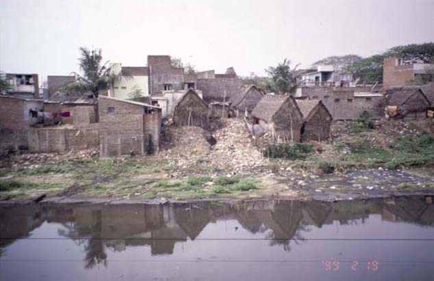 Two important metro cities of India, viz. Bangalore and Chennai are discussed. The aim of the study was to understand the problems of increasing flooding incidences in urban areas and related contexts of urban development and ecological issues. Data of secondary origin have been collected and interpreted in the context of flood risks and urban management. The paper also conveys wider issues and lessons for flood challenges in Indian cities and towns.
Villages in north Bihar sinking in Bagmati's sand - Entire flood control planning needs thorough review - Article by Dinesh Kumar Mishra in d-sector.org
Posted on 16 Jun, 2011 03:56 PM The Bagmati Embankment separating riverside on the left and countryside of the right near Ibrahimpur – Electric poles suggest the height of the embankment
One often hears about the civilizations buried under earth and attributes various reasons for such disappearance of life from a particular place. Excavations reveal the way of life the people might have had before they chose to leave their villages and towns and allowed the nature to take its own course. These accounts are available in books and we all believe the process told to us by historians and archaeologists. These are all conjectures that are revealed by scientific investigations but how many of us have seen, not read, how the civilizations get buried under the debris created by nature? There are places in Bihar where one can see the process of disappearance of civilization and the villages getting buried under the sediments brought by rivers.