Photos, Illustrations and other Images
Tamil Nadu agriculture department - Policy note 2009- 2010
Posted on 02 Sep, 2009 12:07 PMThis policy note 2009-2010 includes the following chapters:
Pictures from the Bagmati embankment breach in Bihar in 2009
Posted on 03 Aug, 2009 10:10 AMThe google map at this URL shows Runi Sayedpur and Sitamarhi, along national highway 77: http://tinyurl.com/lxwfmj
Cyclone Aila 2009
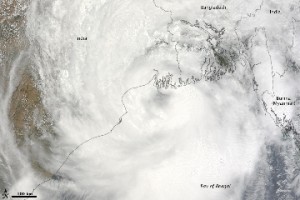
Posted on 01 Jun, 2009 11:27 AMTropical Storm Aila struck southern Bangladesh and eastern India on May 27, 2009. The New York Times reported that floods and mudslides killed at least 191 people and left hundreds of thousands more homeless. As of May 27, the death toll was expected to rise. Images from The Nasa Earth Observatory.
The Moderate Resolution Imaging Spectroradiometer (MODIS) on NASA's Terra satellite captured this true-color image of Aila on May 25, 2009, the same day that the storm temporarily strengthened to a Category 1 cyclone. Aila almost completely fills this scene, stretching from the Bay of Bengal deep into India, Bangladesh, and Burma (Myanmar). On May 25, Aila's wind speeds ranged from 74 kilometers per hour (46 miles per hour or 40 knots) to 120 kilometers per hour (75 miles per hour or 65 knots). More information and detailed images can be accessed here:Cyclone Aila
NASA Earth Observatory: Cyclone Bijli
Posted on 07 May, 2009 12:03 PMImage & Content Courtesy: NASA Earth Observatory
 A ragged-looking Tropical Storm Bijli draped the east coast of India in this image from the Moderate Resolution Imaging Spectroradiometer (MODIS) on NASA's Terra satellite on April 16, 2009. Bijli became a tropical storm in the northwest Bay of Bengal on April 15, and initially headed north, toward the west coast of India. By April 16, it had begun a northeastward turn, however, and the storm was being projected to make landfall in eastern Bangladesh on April 17, according to Unisys. Access higher resolution image here:Cyclone Bijli
Northern Antarctica's Wilkins ice bridge collapse - Images
Posted on 14 Apr, 2009 04:10 AMA narrow ice bridge connecting Charcot Island and Latady Island ”the last remnant of the northern part of Antarctica's Wilkins Ice Shelf broke apart in early April 2009. These photo-like images, from the Moderate Resolution Imaging Spectroradiometer (MODIS), show the break-up of the ice bridge.
Water themed 2009 Calendars - Vigyan Vijay Foundation
Posted on 13 Jan, 2009 10:46 PMThe calendar features images from the VigyanVijay's Eco-water literacy project titled "Youth for Water". VigyanVijay's Eco-water literacy project titled "Youth for Water", in the progress of awareness to youth of different age groups, has evolved a network of institutions with water elements in the NCR- Delhi region. Among these sites, 12 of them have been selected for conducting Eco-water Trails (walks). At each of these selected sites, various key elements were identified for conducting "Water Trials"to the lead volunteers and teachers with keen interest for taking the messages to youth and the communities they are associated with.


