Lakes and Wetlands
Born to fly: A video on the joy of flying in Harike, north India's largest wetland
Posted on 12 Mar, 2013 01:20 PMSource of video: thenitindas
Rights of adivasis over forest lands diminishes; their consent no longer mandatory for all development projects taken up on forest land - Roundup of the week’s news (February 11-17, 2013)
Posted on 18 Feb, 2013 11:18 PMAdivasis' rights over forest lands diminishes
Workshop report: “Evaluating the Jawaharlal Nehru National Urban Renewal Mission (JNNURM) and preparing for the future”, organised by Transparent Chennai on 2 December 2012 at Chennai
Posted on 31 Dec, 2012 08:45 PMTransparent Chennai had organised a workshop on “Evaluating the Jawaharlal Nehru National Urban Renewal Mission (JNNURM) and preparing for the future” on December 2, 2012 at Dakshinamurthy Auditorium in PS Higher Secondary School, Mylapore, Chennai.
The workshop was organised to:
Centre adopts National Water Policy 2012 - Roundup of the week's news (December 24 – 30, 2012)
Posted on 31 Dec, 2012 07:33 AMCentre adopts National Water Policy, 2012
Briefing papers on ‘Jal kothis’, ‘Matka filter’, 'Dug wells' and ‘Phayedemand shauchalaya’: Local innovative solutions in flood prone Bihar by Megh Pyne Abhiyan (2011)
Posted on 29 Dec, 2012 03:14 PMThe briefing papers include the following:

Maps, lakes and citizens: The use of surveys in lake conservation - An article in the Seminar magazine
Posted on 19 Mar, 2012 11:44 AMThis lake system is now decaying with lakes either taken over for urban uses, or choking due to neglect. ATREE and the Bruhat Bengaluru Mahanagara Palike (BBMP) have been engaged in attempting to understand how to restore these lakes for urban use, while maintaining their ecological importance. This article in Seminar describes this attempt.

Water quality monitoring of lakes in and around Bangalore city
Posted on 07 Feb, 2012 03:05 PMIt describes the efforts undertaken by the Karnataka State Pollution Control Board to launch a programme to monitor the water quality of some of the lakes in Bangalore so as to focus the attention of concerned governmental organisations to take up remedial measures to safe guard the water bodies of the "Garden City".
The sources of pollution in lakes are mainly identified as:
Planning as commoning - Transformation of a Bangalore lake - Paper published in the EPW
Posted on 02 Feb, 2012 11:30 AMThis paper published in the Economic and Political Weekly argues that the transformation of human settlements over time can affect the relationship between communities and commons when, for example, social geographies change from rural to urban, or from traditional systems of management to modern bureaucratic systems.
Wetlands for water quality management – The science and technology: A paper from Current Issues in Water Management
Posted on 10 Jan, 2012 10:24 PMThe introduction begins witha brief overview of wetlands: their nature and services offered. These wetlands are ecosystems with water that is static or flowing and characerized by emergent , floating and submerged aquatic vegetation. Some of the services provided by wetlands are fish and fiber, water supply, water purification, flood regulation, recreational opportunities and tourism. It then details the importance of wetlands for water purification.Toxins enter the wetlands through farms, factories and runoff. These toxins are broken down or otherwise buried using a variety of bacteria.

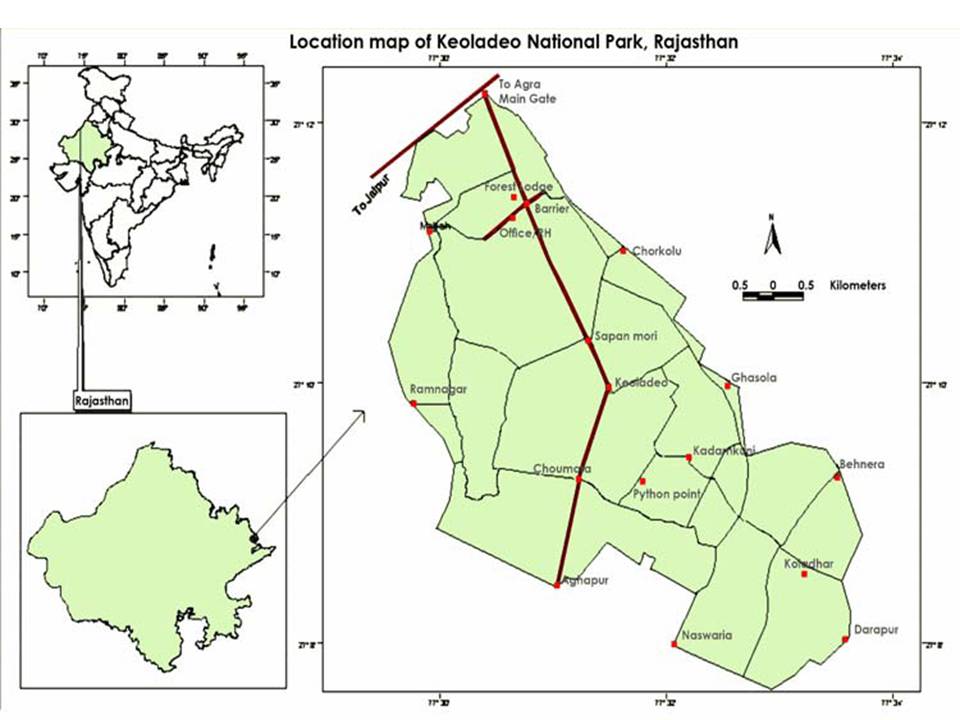
Location map of Keoladeo National Park
Lakes in Mumbai – A draft report by WWF India
Posted on 01 Nov, 2011 08:59 PM This draft report on the study of lakes by the World Wildlife Fund for Nature (India) documents the physical condition of the lakes in Mumbai. Apart from the three lakes - Tulsi, Powai and Vihar that used to provide water to Mumbai residents, there are many lakes in the Bombay Municipal Corporation jurisdiction that are either polluted by human sewage or industrial effluents and have remained neglected with increasing urbanization.
There is very little to no data available on the existence of lakes of Mumbai. Several RTI’s to the government bodies also revealed that there was a lacuna in terms of the availability of the data; as a result most of the water bodies are easily exploited. Under this study the baseline data was prepared with the help of Google Earth website. The areas appearing to be lakes were marked on the Google Earth Images. These were verified by the field staff through onsite visits. The survey was conducted during September and October, 2008 and March, 2009. The study considers only the fresh water lakes which were accessible and saline water impoundments have not been considered.