Bay of Bengal
Background documents on the Bagmati embankment breach: Article and presentation
Posted on 03 Aug, 2009 09:46 AM1) A presentation from the Central Water Commission of the Government of India studying the flood problem on the Bagmati and making some recommendations:
flood-management-in-bagmati-basin
Bagmati river embankment breaches causing floods and widespread destruction
Posted on 03 Aug, 2009 09:09 AMPhotograph of flooding due to breach in Bagmati's embankment, taken by NGO: Ghoghardiha Prakhand Swarajya Vikas Sangh, Madhubani"
River basins and river basin organisations in South Asia
Posted on 22 Jul, 2009 03:12 PMAs part of the research study, River Basins and River Basin Organisations in South Asia, done by the Society for Participatory Development Hyderabad, CapNet South Asia (Read More) and Gomukh Environmental Trust for Sustainable Development Pune (Click Here), data about individual river basins has been collected for the river basins in South Asia.
Dr. GD Agarwal's fast to resume
Posted on 09 Jul, 2009 01:57 AM
- The state government of Uttarakhand promised immediate suspension of all works on the two projects Bhairoghati and Pala-Maneri in its letter of 19th June, 2008 and expressed its full commitment for conservation of River Bhagirathi in its natural form ‘from Gangotri to Uttarakashi’. However construction work on the projects (particularly on Pala Maneri project) leading to destroy Gangaji is going on in full swing. The above makes all assurances to us and to Maa Gangaji look as mere jokes.
- The Government of India committed immediate stoppage of all work on its project Loharinag-Pala in its letter on 19th February, 2009. But the construction work on the site has gone on un-stopped and on an accelerated speed. This again is an act of cruel deceipt.
MWR directed to make the Ganga basin studies public : SANDRP
Posted on 07 Jul, 2009 02:16 AMIn order that is likely to have far reaching implications on water governance in India, the Central Information Commission(CIC) has directed the Union Ministry of Water Resources (MWR) that “any study about water-flow in the river systems of the country must be made available to the general public for its information and education. It is not open to the public authority to hold secret critical information with which lives of millions may be related. Publication of this data informs the people about how the public authority is discharging its appointed functions and whether it was acting accountably about a matter so critical as the nation’s water resources in general and the river systems in particular.” Following an appeal by SANDRP, the CIC has asked the MWR make public the reports of the Central Water Commission & National Institute of Hydrology on the impacts of the hydropower projects on Bhagirathi River in Uttarakhand and for portions that the ministry decides not to make public, “Reasons for holding these parts of the information confidential will have to be recorded, which should be open to scrutiny.” This entire task is to be completed in three months.
Suggestions for a modified approach towards implementation and assessment of Ganga Action Plan
Posted on 11 Jun, 2009 03:20 PMThis paper is written by Vinod Tare, Purnendu Bose and Santosh Gupta of IIT Kanpur to examine the need for an alternative implementation and assessment methodology of River Action Plans in India. The paper illustrates of ‘Ganga Action Plan' (GAP) and its implementation near Kanpur, Uttar Pradesh, to assess the methodology.
Exploring options for sustainable water management in the Malaprabha river basin - Proceeding of the final stakeholder workshop held in November 2008 in Belgaum, Karnataka
Posted on 03 Jun, 2009 03:17 PMThis document deals with the proceeding of the final stakeholder workshop titled “Exploring options for sustainable water management in the Malaprabha River Basin”. The one day workshop was jointly organised by the Centre for Interdisciplinary Studies in Environment and Development (CISED) and the Norwegian Institute of Water Research (NIVA) at Belgaum on 5th November 2008.
Cauvery water disputes tribunal gave its final orders regarding the inter-state river water sharing (2007)
Posted on 02 Jun, 2009 12:21 PMThe Cauvery Water Disputes Tribunal (CWDT) was constituted by the Government of India in June 1990 to adjudicate the water dispute regarding inter-state river Cauvery and the river valley thereof. The Tribunal had passed an Interim Order in June, 1991 and further Clarificatory Orders on the Interim Order in April, 1992 and December, 1995. The Cauvery Water Disputes Tribunal ha
Groundwater Arsenic Contamination in the Ganga-Padma-Meghna-Brahmaputra Plain of India and Bangladesh
Posted on 01 Jun, 2009 04:20 PMGroundwater Arsenic Contamination in the Ganga-Padma-Meghna-Brahmaputra Plain of India and Bangladesh.This report from the Jadhavpur University highlights the intensity and magnitude of the arsenic contamination in the Ganga-Meghna-Bramhaputra plain which includes states Uttar Pradesh, Bihar, Jharkhand, West Bengal and Assam covering an area of 569,749 sq km.
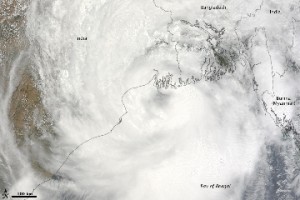
Cyclone Aila 2009
Posted on 01 Jun, 2009 11:27 AMTropical Storm Aila struck southern Bangladesh and eastern India on May 27, 2009. The New York Times reported that floods and mudslides killed at least 191 people and left hundreds of thousands more homeless. As of May 27, the death toll was expected to rise. Images from The Nasa Earth Observatory.
The Moderate Resolution Imaging Spectroradiometer (MODIS) on NASA's Terra satellite captured this true-color image of Aila on May 25, 2009, the same day that the storm temporarily strengthened to a Category 1 cyclone. Aila almost completely fills this scene, stretching from the Bay of Bengal deep into India, Bangladesh, and Burma (Myanmar). On May 25, Aila's wind speeds ranged from 74 kilometers per hour (46 miles per hour or 40 knots) to 120 kilometers per hour (75 miles per hour or 65 knots). More information and detailed images can be accessed here:Cyclone Aila
