North 24 Parganas District
Living through Cyclone Amphan and Covid-19: Climate change and water security
Posted on 07 Jun, 2020 11:33 AMThe nomenclature of cyclones and hurricanes is developed much in advance through multilateral processes in the region. The name Amphan (Sky in Thai and Akash in Bangla) was chosen from a long list of potential disasters long back.

How bio-restoration is helping revive degraded mangroves in Sunderbans
Posted on 17 Sep, 2019 06:06 PMNew Delhi, September 17 (India Science Wire): A new technology developed by Indian scientists for ecological restoration is helping in revival of mangroves degraded due to rising sea levels, climate change and human intrusion in the Sunderbans in West Bengal.

Ways to keep arsenic away
Posted on 11 Oct, 2016 10:12 PMFor villagers at Madhusudan Kathi, the handpumps serving water from an unprotected source led to arsenic contamination, making water from these pumps risky to drink.

Community effort saves mangroves
Posted on 04 Aug, 2016 09:52 AMCome monsoon, the villages in the Sundarbans islands witness nature’s fury with floodwaters overriding all boundaries and inundating huge tracts of land. As such, the earthen embankments, stretching to 3600 kms on the 54 inhabited islands out of a total of 102 in the Sundarbans, protect scores of people from floods and tidal waves.

After Cyclone Aila, farming nurtures food, faith in Sunderbans
Posted on 14 Oct, 2015 09:53 PM“Another flood like Aila should never happen again, but if it does, we have the knowledge to start working on our soil again”, remarks Binota Munda of Nebukhali village in Hingalganj block, North

Bihar Government bans plastic packaged water bottles in all its departments
Posted on 09 Feb, 2015 01:35 PMBihar's government offices to soon become free of plastic bottles

The real picture of arsenic pollution in West Bengal, India
Posted on 17 May, 2011 11:34 AMArsenic poisoning in these districts is a serious environmental problem and is affecting the health of millions of people in the State. The problem has been aggravated with increase in groundwater exploitation leading to leaching of arsenic located in upper layers of sediment down into the deep aquifers.
During my visits to these districts, I have had dreary experiences -
Cyclone Aila 2009
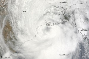
Posted on 01 Jun, 2009 11:27 AMTropical Storm Aila struck southern Bangladesh and eastern India on May 27, 2009. The New York Times reported that floods and mudslides killed at least 191 people and left hundreds of thousands more homeless. As of May 27, the death toll was expected to rise. Images from The Nasa Earth Observatory.
The Moderate Resolution Imaging Spectroradiometer (MODIS) on NASA's Terra satellite captured this true-color image of Aila on May 25, 2009, the same day that the storm temporarily strengthened to a Category 1 cyclone. Aila almost completely fills this scene, stretching from the Bay of Bengal deep into India, Bangladesh, and Burma (Myanmar). On May 25, Aila's wind speeds ranged from 74 kilometers per hour (46 miles per hour or 40 knots) to 120 kilometers per hour (75 miles per hour or 65 knots). More information and detailed images can be accessed here:Cyclone Aila
Videos related to the construction and use of dugwells in the arsenic prone villages of West Bengal
Posted on 22 May, 2009 12:48 PMVideos related to the construction and use of the treated, improved dugwells in the arsenic prone villages of West Bengal in India to provide arsenic safe water.
Click Here
