Groundwater depletion has reached such alarming proportions in the semi-arid and arid regions, despite huge investments in watershed development programmes by the state and central governments and the international donor community. One of the stated aims of these programmes is to mitigate drought and ensure water availability throughout the year. However, the ground water is extracted from deeper and deeper levels to cope with recurring droughts. Increase in the area under irrigation, has often been achieved through a dramatic increase in the number of wells, accompanied by a decrease in the area irrigated per well. The trend of chasing ground water table without a proper management system has ruined hundreds of farming communities.
While water shortage and drought are caused by a combination of factors, including meteorological ones, one of the main reasons for the crisis is the lack of control of water use. In Andhra Pradesh, Government Watershed Management initiatives have largely focused on increasing and re-distributing water supply through water harvesting structures. Water utilisation, with a focus on equitable and sustainable sharing of water between different user groups and uses was neglected so far. A research has shown that the losers, as a result of inappropriate water harvesting structures, could be the poor who use water for domestic and other non-irrigation purposes such as livestock rearing, fishing, or washing. The existing tendency to focus only on irrigation has often neglected other water uses, including domestic water supplies and environmental sanitation.
When looking at irrigation alone, it becomes clear that increase in the area under irrigation has often been achieved through a dramatic increase in the number of wells, accompanied by a decrease in the area irrigated per well. This means that some farmers are spending huge resources on digging wells and installing pumps without receiving adequate returns.
The famous "chasing of the water table" phenomenon is widespread. In this chase, the private investments of the poor people to access water have ruined their economy because wells dry up and they are left debt traps. Agriculture is no longer a viable option as they do not have the capacity to invest in new bore-wells and neither is water available.
In order to mitigate this problem, a new law (APWALTA)3 to limit the drilling of bore-wells and to ensure a minimum distanc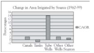 e between wells has recently been legislated, but not implemented yet. In most parts of the state, there are far too many wells to pump the available ground water.
At the Centre for World Solidarity (CWS), we believe local people should come together, discuss the problems, and plan strategies to manage both conservation and utilisation of water. Only then, it is possible to collectively decide to regulate the amount of water pumped from the existing wells, and to share the available water resources equitably between all households. The unsustainable over-utilisation of ground water and the monopolisation of water resources by a few farmers needs to be checked.
The gross irrigated area in India in1960-61 was 28 million hectares. In 1998-99,it increased by 76 million hectares with a sharp Compounded Annual Growth Rate (CAGR) of 2.2 per cent 4 . It is evident from the data that the tanks recorded a reduced growth rate by 1.1 per cent whereas much of the growth is accounted by ground water.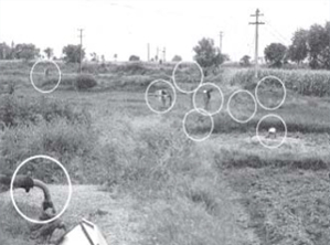 “One can draw as many inferences as possible against bore-wells and on its impact on Small and marginal farmers, but people do need water… The rural dependencycof rural population of india on ground water is more than 85 per cent and it contributes to 54 per cent of irrigation.” 5 Moreover, the invest-ment to tap ground water is basically derived from individual farmers whereas in other cases it is mostly public investments. One of the reasons identified for the spate of farmers. Suicides 6 in Andhra Pradesh is due to futile investments and over exploitation of ground water table. There are no systems available to manage ground water. When regions face continuous droughts, the impact is harsh. So far, the only way to manage drought is to deepen bore-wells. The challenge is to find ways to balance demand and supply while ensuring an adequate ground water buffer. To make this happen, regulations are required at the community level.
Mogali Chetla Thanda shows a way forward
M.C. Thanda in Kadiri Mandal of Anantapur district is a part of the Kothakunta watershed. It is an independent initiative under the Rayalaseema watershed development program and is facilitated by Janajagruti, an NGO based at Kadiri and local partner organisation of CWS. The district receives the lowest rainfall in the state and the second lowest in the country with an average rainfall of 550 mm per year. As expected, this region is frequently suffers from droughts.
Table 1 : Population status – Kothakunta watershed
| S.NO | Total Families | Total Population | ||||||||
| SC | ST | BC | OC | Total | SC | ST | BC | OC | Total | |
| 1 | - | 90 | 11 | 11 | 112 | - | 393 | 53 | 77 | 523 |
Kothakunta watershed covers 670 acres of land covering five hamlets. It has 112 households of which 80 per cent are schedule tribes (Lambada).
Table 2: Resource distribution - Kothakunta watershed
| S.NO | Land Particulars | ST | SC | BC | Total |
| 1. | Landless | 2 | - | - | 2 |
| 2. | Below 3 Acres | 49 | 8 | 2 | 59 |
| 3. | 3 to 5 Acres | 29 | 3 | 5 | 37 |
| 4. | 5 to 7 Acres | 10 | - | 2 | 12 |
| 5. | 7 to 10 Acres | - | - | 2 | 2 |
| Total | 90 | 11 | 11 | 112 |
About 54 per cent and 88 per cent of the total households own less than 3 and 5 acres of land respectively. More than 80 per cent of the households used to migrate seasonally before the programme. Most of the 670 acres of watershed area was degraded. This case study explores the process in social regulation of water management in M.C. Tanda, the main hamlet.
Watershed Development
Watershed development work started with organizing the community. The process of facilitation led to empowerment with a special focus on women. Under the programme 29 acres of fallow lands were reclaimed while three acres of saline land could not be reclaimed. With a combination of farmers. own technical knowledge and experience and with external advice, the entire 670 acres land was treated, starting at the ridge. Earthen and stone bunds were constructed on the farmlands and rock fill dams and gully checks in the drainage courses were built.
Apart from repairing the breached Water Harvesting Structures (WHS), eight new structures were constructed. It is very important to recharge ground water before planning for any usage system. In order to achieve this, a Water User Group (WUG) was formed for each WHS. The user groups played an active role in participatory design of the structures. An initial plan was developed by the people, and later the plan was verified by socio.technical experts. The user groups resolved internal conflicts and were responsible for the management of WHS. In many marginal lands, clearance of stones and boulders substantially increased the net cultivable area. The project also provided for application of tank silt and farmyard manure to restore the productivity of the degraded lands. The project invested Rs.2,810 per acre for comprehensive treatment. The amount of investments was agreed upon in a collective manner which ensured flexibility for different activities.
People established their stakes by contributing 50 per cent of the cost of structures in private land and 25 per cent in common property resources. The details of work on Private Property Resources (PPR) and Common Property Resources (CPR) is presented in Table 3.
| Table 3 : Details of the work carried out | |||||
| Sl. | Particulars No | Compiled Units | Cost NGO | People's Contribution | Total |
| 1) | PPR (Private Property Resources) | ||||
1)
| Earthen Bunds | 353.21 Ac | 83469 | 83469 | 166938 |
| 2) | Waste Weirs | 309 (Nos.) | 32737 | 32737 | 65474 |
| 3) | Stone Bunds | 94 AC | 38000 | 38000 | 76000 |
| 4) | Bush Clearance | 48 AC | 21613 | 21613 | 43226 |
| 5) | Strengthening of Earthen bunds | 353.21 AC | 23629 | 23629 | 47258 |
| 6) | Strengthening of Old Earthen bunds | 152 AC | 10750 | 10750 | 21500 |
| 7) | Strengthening of Stone Bunds | 28 AC | 5170 | 5170 | 10340 |
| 8) | Strengthening of old stone bunds | 54 AC | 13200 | 13200 | 26400 |
| 9) | Repairing of Old Gully checks | 23 Nos | 30047 | 32450 | 62497 |
| 10) | Construction of Gully Checks | 1890(Nos) | 38673 | 38673 | 77346 |
| 11) | Horticulture | 32 AC | 41980 | 41980 | 83960 |
| 12) | Fallow Land development | 17 AC | 42000 | 42000 | 84000 |
| 13) | Fodder Seed | 2 No. | 6300 | 5000 | 11300 |
| 14) | Drinking water pond for cattle | 1 No | 1300 | 700 | 2000 |
| 15) | SHG Support | 5 Groups | 100000 | 100000 | 200000 |
| 16) | Milch Animals | 13 Nos | 130000 | - | 130000 |
| 17) | Seed Bank | 1 | 50000 | - | 50000 |
| Sub Total: | 1158239 | ||||
| II) Community & Organization Development | |||||
| 1) | Training & Meetings | 4 | 16600 | - | 16600 |
| 2) | SWC | 1 | 3000 | - | 3000 |
| 3) | Common Lands | 1 | 2700 | - | 2700 |
| 4) | Peoples Institutions | 7 days | 5500 | - | 5500 |
| 5) | Exposure Visits | 7 | 26290 | - | 26290 |
| 6) | Cultural Training Programs | 4 | 7000 | - | 7000 |
| 7) | Rainfall Measurement | 1 | 1000 | - | 1000 |
| 8) | Centrifugal Pump | 1 | 1300 | - | 1300 |
| 9) | Support for Landless and Single Women Group | 1 | 30000 | - | 30000 |
| 10) | IPM & NPM | 2 | 5000 | - | 5000 |
| 11) | Medicinal Plants Identification Training | 1 | 4000 | - | 4000 |
| Sub Total | 102390 | ||||
| III) CPR (Common Property Resources) | |||||
| 1) | Common Revenue Land | 210 AC | 117065 | 29266.25 | 146331.25 |
| 2) | Gully checks | 154 (Nos) | 15480 | 5160 | 20640 |
| 3) | Gully Checks New Area | 105 (Nos) | 12000 | 4000 | 16000 |
| 4) | Seed dibbling and Plantation | 210 AC | 5000 | 107 | 5107 |
| 5) | Contribution for Watch & Ward | 210 AC | 25075 | 9000 | 34075 |
| 6) | Nursery | 100000 | 90820 | 25055 | 115875 |
| 7) | Water Harvesting Structures | 7 | 227067 | 56767 | 283834 |
| Sub Total: | 621862 | ||||
Accessing user right on common lands by women's groups
The programme kept women at the centre of decision making. Special efforts were made to build their leadership and to ensure their representation in the committees. The needs of single women were also identified and addressed. Thrift and credit groups were formed and their participation and stake in all the initiatives were clearly established. With facilitation from Janajagruti, the women.s groups began protecting 210 acres of common property land, after necessary land treatment. Clear norms were established for protection and a person was appointed for watch and ward. With proper lobbying, the community could also manage usufruct rights from the government revenue office. Regeneration was rapid and more than 30 different species of trees survived. Fodder is harvested regularly from this land.
With land treatment, WHS and protection of common land in the upper reaches, the ground water levels increased significantly. The 11 defunct open wells were rejuvenated. With availability of grazing land, fodder and bio-mass, livestock population doubled from 980 (in 1995) to 1824 (in 2000). The revenue forest lands are fast regenerating, providing fodder, timber, fire wood, minor fruits etc. to the communities.
Accessing regenerated water
A water balance study conducted by AFPRO laid the ground for accessing ground water. The community considered the option to revive the defunct open wells. However, after assessing the high cost of reviving the wells, the people with the help of AFPRO, decided to dig new wells. At this stage of the programme (in the third year), Janajagruti could successfully negotiate with AP Wells to drill 11 bore-wells. Long discussions and technical surveys followed the proposal to identify appropriate sites. Issues like ensuring equal spread of benefits, establishing appropriate norms for sustainability were the major points of discussion.
| Table 4: Coverage of households under bore-well irrigation in M.C. Thanda and Ramlanaik Thanda. | |||
| S.NO. | Range of Irrigated Area (acres) | For each WHS No. of Households in Kharif | For each WHS No. of Households in Rabi |
| 1. | 0 | 00 | 000 |
| 2. | 00.1-0.5 | 19 | 35 |
| 3. | 0.6-1.0 | 31 | 34 |
| 4. | 1.1-1.5 | 06 | 15 |
| 5. | 1.6-2.0 | 07 | 02 |
| 6. | 2.1-3.0 | 21 | 00 |
| 7. | 3.1-10 | 02 | 00 |
Due to contiguity of plots, many times, the group would be formed among brothers. The bore-wells were energised with the help from the Irrigation Development Corporation.
A uniform distribution of the bore-wells points across the watershed was agreed upon. The AFPRO study confirmed that there was still a ground water buffer of 30 per cent which indicated that the extraction was within renewable range. With these established norms all the households in the watershed could irrigate at least a part of their land holdings (0.5 acres to 3 acres) except three households. Thus, the community could tap most of the water regenerated by their own efforts. Each bore-well cost about Rs. 1,00,000/- including the cost of energisation. The farmers contributed 15 to 20 per cent of the total expenditure.
Key process steps followed on groundwater management
Stocktaking of water resources: A stocktaking exercise of water resources was carried out to determine availability of water and use mechanisms. The ground water buffers are estimated before and after drilling bore-wells. Members of the Watershed Committee, User Groups and SHGs participated in discussions and the decision making process.
Prioritisation of water usage: The present practices and issues in management of drinking water, irrigation water and other purposes in different periods of the year are debated. Drinking water for both, humans as well cattle was identified as a priority. The community takes care of managing the hand pumps and the rain gauge is installed to record the quantum of rainfall.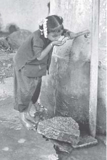 Crops and cropping pattern: The distinction and choice between water conserving crops and water intensive crops, is made consciously at the village level. Cropping pattern influenced not just an individual choice but based on the water availability in the region. Paddy and sugarcane, both require intensive irrigation, are banned. Cultivation of food crops are encouraged on small patches of their land to ensure food security at the family level.
Participatory ground water monitoring:
Hydrological monitoring techniques are developed at the community level. Members take the readings of the ground water level and display it at a common place in the village. This database is helpful for rational decision making. It helped to determine the cropping pattern, water prioritization and water use mechanisms.
Social regulations at different levels: Through discussions community members have arrived at a set of norms and regulations for water use. These regulations were formed at different stages and varied with resources and institutions.
Regulations on accessed water
- No individual bore-wells but group bore-wells: 6 to 7 farmers together drilled one bore well that irrigate around 10 acres. For every 10 bore-wells, one transformer is installed
- No new bore-wells to be dug
- Maintenance is a collective responsibility. Agreement on stamp paper; a lawyer explained the details of the agreement
- Members cannot sell their land without the permission of others in the group
- Water to be shared equally among the members of the group
- Rice and sugarcane are banned
- Only half the acreage of kharif is permitted to be irrigated in the rabi season for growing food crops.
- Bore-well Committee enforces regulation of 200 mts distance between bore-wells
- Even if a farmer does not use water, he shares the cost of electricity and repairs equally (this forces them to use water).
Regulations on crops
- Crops to be grown depending on the rainfall. Since paddy and sugarcane consume more water these are banned.
- Ceiling on extent of irrigation -Only 50 per cent of the extent irrigated in kharif is allowed to be sown in rabi .
Regulations at institutional level
- Watershed committee has 13 members and the decisions are binding on the village.
- Women have equal status in terms of membership.
- Conducive atmosphere to be created for women for active participation, decision making, skill training. In all works, equal wages to be paid.
- Priority for drinking water and fodder for animal in all village activities
Regulations to manage common lands and village assets
 210 acres of village common land to be protected through social fencing
- User right should be with women's group
- No member is allowed to take axe and cut the trees
- Women group decide the time to harvest bodha (thatch) grass
- Seven water bodies newly constructed are village assets. For each body, a user group is formed to take the responsibility of management
- Ground water is the village asset. Community regularly monitors the ground water levels and displays the reading in a public place
Change in livelihoods
The bore-wells with appropriate management systems changed the livelihood profile of the village. In M.C. Tanda and Ramlanaik Tanda (Table 4 presents the distribution of area under bore-well irrigation) 86 out of 89 households could access bore-well irrigation
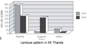
in some patches of their lands. Thus, the benefits of irrigation spread across most of the families. Rabi crops with irrigation were grown in about 210 acres (See Graph). At an average of 50 person days employment per acre of crop area, nearly 10500 days of dependable employ-ment is being gene-rated during rabi season (major migra-ting season) within the village. This amounts to nearly 100 days employ-ment per household per rabi season. The wage income during lean season is a major factor in the transformation of the village. Distress migration has decreased; almost 85 per cent of households migrated seasonally earlier. Even during the continuous drought years of 1999, 2000, 2001,2002, and 2003 a minimum of 125 acres of land was cultivated with protective irrigation while the neighbouring villages could not grow any crop. Men and women receive equal wages not only in the project work but also in the regular agricultural work.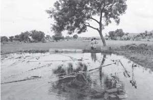 With assured fodder and water, the livestock population has more than doubled in seven years time, from 980 (in 1995) to 2093 (in 2002). The major shift is in the population of small ruminants. The reason for this is the process of incremental development where people can afford to invest and are prepared to take risks. Contrary to the understanding that goat destroys vegetation, its population has increased by 250 per cent, and without any decrease in the vegetation. The water needs of the village are well recognized and no one travels more than 100 metres to fetch water. Minor repairs and as well as overall maintenance of the pumps are done by the community.
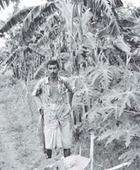
As irrigation covers most of the house-holds, the yield of food crops has also stabilised. Food security was ensured even during periods of drought, as limited but protective irrigation is available to most of the households in the village. Of the total 86 households, of M.C. Tanda and Ramlanaik Tanda, 72 have managed to break the poverty trap, as they no longer depend on wage income at any point of year for their food. These households have an average irrigated area of about one acre (during rabi ). Eleven households, though depend primarily on agriculture (this shift has taken place), may need to partly depend on wage income sometime in a year. So far, only three households have not been able to avail of the benefits of this project for reasons peculiar to their situation.
Success factors
Following are the factors contributing to the achievements in M.C. Tanda in Kothakunta watershed.
- M.C. Tanda is a typical homogenous Lambada hamlet of tribal community, with large area under common and degraded agricultural land. Almost all the households have some land with varying quality.
- Incremental development planning with emphasis on process and ownership. People.s contribution and ownership of the programme is at higher stakes. There is also flexibility in the investments executed on the basis of the needs of a particular land
- To arrive at balanced water supply and demand mechanisms, the community needs training, exposure visits, and a continuous dialogue. In other words . a standing conflict resolution mechanism at community level is developed
- Janajagruti.s leadership and investments on building capacities of the facilitating team. Central focus is on building watershed institutions and its capacities, with norms of equity and gender sensitivity.
- The building of institutional capacities in the village is reflected in regenerating 210 acres of common land and acquiring the usufruct rights
- Comprehensive treatment . land, drainage lines, water harvesting structures, composting, common property resources etc and integrating livestock interventions.
- Above all, bore-wells to access regenerated water resources with norms that ensure equity and sustainability. People's interest in learning new skills such as ground water level measurement.
- Unity in terms of enforcing social regulations at different levels.
- Watershed works have brought large areas under cultivation and also improved productivity and stability of these lands substantially. Access to investments on bore-wells is a crucial turning factor in terms of poverty alleviation. As the bore-well investment has come at one time covering the whole village with clear norms and conditions, there was a possibility for negotiating spread and equity in accessing ground water.
References
- C.H.Hanumantha Rao, S.Mahendra Dev (2003) . Andhra Pradesh Development- Economic Reforms and Challenges Ahead.
- Ramaswamy R.Iyer (2003) . Water Perspectives, Issues, Concerns
- Christopher Scott, Narayana Peesapaty, Jean-Christophe Marechal . Water Balance Tools. (Water Summit 2003)
- Charles Batchelor, Rama Mohan Rao, A.J. James .Water Resources Audit.
- Srinivas Mudrakartha, .Status and Policy Framework of Groundwater in India.
- Anwar et al (2004) .Social Regulations in Water Management . An Action Research Initiative.
- Ranidra et al (2002) .Natural Resource Development and Management for Enhancement of Livelihoods of the Poor in Andhra Pradesh. for Society for Elimination of Rural Poverty
We would like to thank German Agro Action for very kindly sharing the case studies for the portal.
Taken From Best Practices in Water Management-Case Studies from Rural India-2005 German Agro Action, 2005
- S.K.Anwar
- Batchelor et al. 2002
- Andhra Pradesh Water Land, and Trees Act (APWALTA) - Government of A.P introduced the Act in 2002 to promote water conservation and Tree cover and regulate the exploitation and use of ground water and surface water for protection and conservation of water resources, Land and environment and matters, connected therewith or incidental. Later the Act was amended in 2004.
- Christopher Scott et al 2003 on the basis of data from the Ministry of Agriculture and Cooperation
- Ramaswamy R. Iyer
- In Anantapur district alone over 200 committed sucide in 2003
 (CWS) has been actively involved in development work in India since 1960. CWS in partnership with NGOs and networks focusses on natural resource management, gender, dalits, tribals, minorities, children, PRIs and human rights in the states of Andhra Pradesh, Tamil Nadu, Orissa, Jharkhand and Bihar. CSW also associates itself with regional, national and international initiatives. In water related issues, CSW has evolved models to equip the community with drought mitigation preparedness strategies through better water management and regulations at the communtiy level. (CWS) has been actively involved in development work in India since 1960. CWS in partnership with NGOs and networks focusses on natural resource management, gender, dalits, tribals, minorities, children, PRIs and human rights in the states of Andhra Pradesh, Tamil Nadu, Orissa, Jharkhand and Bihar. CSW also associates itself with regional, national and international initiatives. In water related issues, CSW has evolved models to equip the community with drought mitigation preparedness strategies through better water management and regulations at the communtiy level.www.cwsy.org |