Participatory flood risk mapping is a well-recognized and widely implemented tool for meaningful community involvement in disaster risk reduction. It generally entails a process that enables the local community to physically locate on maps the impending flood risks in communities, their resources, and the countermeasures they can adopt.
Local communities are the primary victims of the event and also the first to respond when disaster strikes. Therefore, local communities’ perception of the spatial distribution of risk plays a critical role in disaster risk reduction. The participatory flood risk mapping also helps obtain information that is otherwise very difficult to extract.
The participatory flood risk mapping is also considered to be an effective tool to enhance the community’s risk awareness and preparedness intention, as it provides a visual demonstration of risks through maps.
The effectiveness of participatory flood risk mapping remains anecdotal. The claims made in favour of participatory flood risk mapping are seldom empirically tested. Moreover, participatory mapping has rarely been identically carried out in two different places by two different organizations. Hence, the same exercise has varied outcomes and success rates in different places.
This seemingly effective, widely implemented participatory disaster risk reduction tool has remained unclear about how and to what extent participatory flood risk mapping can meaningfully engage local communities in the decision-making process. This opaqueness creates an urgent need to investigate what makes the participatory flood risk mapping tool effective for community participation in disaster risk reduction.
The participatory flood risk mapping exercise has rarely been applied identically in two different places by two different organizations, which produces varied and uncertain outcomes.
This study by Samaddar et al published in the International Journal of Disaster Risk Science examines what factors and methods make participatory flood risk mapping an effective participatory disaster risk reduction tool. This study identifies the process-based criteria of participation.
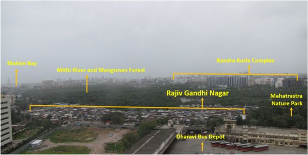
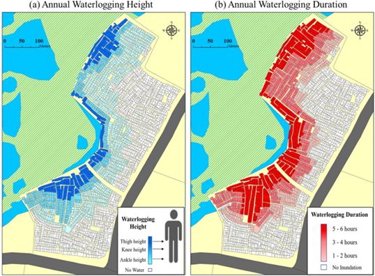
A participatory flood risk mapping exercise conducted in a flood-prone informal settlement in Dharavi, Mumbai is discussed. The exercise was carefully designed to meet the process criteria of effective participation. Finally, using qualitative research methods, the effectiveness of participatory flood risk mapping is evaluated from the local community perspective.
The findings show that ensuring community livelihood security and true involvement of marginalized groups, preparing an action plan, and incorporating fun and cultural connotations into the facilitation process are critical components that enhance community participation through participatory flood risk mapping in disaster risk reduction.


Key findings and planning implications for disaster risk reduction
- Flood risks under livelihood risks: More than the facilitation process and style, the agenda and scope of the exercise were found critical for participants’ motivation to participate. Local leaders found it extremely challenging to engage people in participatory flood risk mapping activities, especially in the initial phase, because people’s priorities were livelihood survival needs rather than the flood risk issue. Therefore, participatory flood risk mapping activities must illustrate the direct connection between the flood and the community’s jobs, income, shelter, and health problems.
The study findings reiterate the importance of sufficiently integrated disaster risk management such that disaster risk is not treated alone but rather is analysed in relation to other life risks, including employment risks, financial risks, health risks, and so on. When the livelihood of local communities is interlinked with a participatory flood risk mapping exercise, communities at risk have more incentive to participate in the program. This helps to build social resiliency and to transform local communities.
- Hope and options for flood risk reduction: Participants reported that over time local communities have developed a fatalistic attitude toward flood risks. Because floods became an annual phenomenon, and people did not yet find any options to reduce the incurred loss, solely knowing the risk is not adequate for the community’s sustainable participation.
Participatory flood risk mapping can guide the community to possible flood countermeasures they can adopt to reduce loss and protect livelihood.
- Self-reliance: Local communities found themselves helpless to negotiate with external agencies to pursue their visions of disaster risk reduction because of a lack of financial, technical, and human resources. Local communities suggested that local youths could be trained to carry out participatory flood risk mapping independently. That would empower them to implement their action plan without external help.
- Self-trust and self-recognition: Social trust is very fragile among the stakeholders due to several socio-political reasons in slums areas. Local communities suggested celebrating the contribution of local volunteers and leaders through advertising their names, celebrating their achievements, and so on. This would increase the mutual trust within the community to cooperate and collaborate for community well-being in activities like the participatory flood risk mapping initiative.
Furthermore, the involvement of different stakeholders, such as municipal engineers and government officials, was suggested to increase the credibility of the participatory flood risk mapping process.
- Social and cultural viability: Local communities considered the participatory flood risk mapping to be very intensive in terms of time and labour. Leaders and volunteers had to devote lots of time and resources to organising the activities. Therefore, local leaders should be recognized for organizing social and cultural activities. Linking the participatory flood risk mapping with cultural activities or sports as a side event would create higher social acceptance and interest in the exercise.
- Sustainability: Social activities like participatory flood risk mapping terminate easily after a while. The local communities argued that some of the plans of participatory flood risk mapping must be tried to enhance people’s motivation. Visible results can encourage people to keep participating in collaborative activities.
The full paper can be viewed here