The area suffers from water scarcity, natural resource degradation, low crop productivity (1–1.5 t/ha), low rainwater use efficiency (35–45 per cent), high erosion, poor soil fertility, frequent droughts, poor irrigation facilities, heavy biotic pressure on forests, inadequate vegetation cover and frequent crop failure resulting in scarcity of food, fodder and fuel. The region has serious limitations of ground and surface-water availability and heavily depends upon perched water for drinking as well as irrigation.
Surface-water harvesting and storage in large ponds for meeting irrigation and drinking-water requirement has been in practice since ages. However, the storage capacity of such ponds has reduced due to silting. Accelerated pumping from shallow dug wells (using electric motor/diesel pump) has further reduced the groundwater level. Majority of wells in the region go dry, particularly during summer months. Often, the region experiences drinking water shortage.
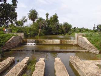
In this context, the Garhkundar–Dabar watershed was taken up for watershed development by the National Research Centre for Agroforestry, Jhansi in 2005. Soil and water-conservation measures in the watershed included construction of (a) eight check dams in series in approximately 10 km total length of third and fourth-order streams, (b) 150 gabion structures laid across the first and second-order streams to check gully formation and silt inflow in main water course (c) three ‘khadins’ (water spreaders) were constructed in depressions to check the concentrated flow of run-off water and (d) bunding was carried out along the margins of the fields in 40 ha area for in situ water harvesting and erosion control; these bunds were provided with proper spillways (15 numbers) for safe disposal of excess water.

Check dam in Garhkundar–Dabar watershed
To compare and know the impact of integrated watershed treatment on runoff, and soil and nutrient loss, the area adjacent to the treated watershed was also gauged as an untreated watershed. The results indicate that –
- Adoption of integrated soil and water conservation measures on a watershed basis not only reduced run-off, but also increased water availability in time and scale. The peak discharge from the treated watershed in 2009 was lower (0.018 m3/s/ha) compared to the untreated watershed (0.028 m3/s/ha). Similarly, total runoff recorded from the treated watershed was lower (41.5 mm or 5.4 per cent of annual rainfall) than the untreated watershed (77.3 mm or 10.1 per cent of annual rainfall).
- Check dams generated about 25,000 m3 water-storage capacity in the watershed. At present, enough water is available in most of the wells round the year.
- The number of dry wells in the watershed reduced to 2 per cent in June 2009 from 86 per cent in June 2006. Integrated watershed management interventions had a pronounced impact on groundwater recharge.
- Soil loss from the untreated watershed was 76 and 73 per cent higher compared to the treated watershed in 2008 and 2009 respectively. N and P losses in 2008 from the treated watershed were 7.35 and 4.97 kg/ha respectively, whereas the corresponding losses from the untreated watershed were 12.6 and 8.54 kg/ha respectively.
Thus, well-planned and properly distributed soil and water-conservation measures comprising construction of field bunds, gabions on first and second-order streams, water spreaders in depressions and a series of check dams on third and fourth-order streams not only reduced soil and nutrient loss, but also generated increased water resources besides imparting drought-proofing. The study indicates that the water crisis in the drought-prone Bundelkhand region can be averted by adopting the model described here, even with 50 per cent deficit rainfall, and the region can be transformed into a water-adequate region.
Download the paper below -