Along the east coast of India, five massive wetlands--starting from Point Calimere (Kodiakarai) and Pulicat in Tamil Nadu, the Krishna-Godavari basin in Andhra, Chilika in Odisha and Sundarbans in West Bengal--provide the necessary moisture for monsoon winds to precipitate. While it may be difficult to comprehend the intricacies of how monsoons work, one thing is clear--these wetlands need to remain wet for rain clouds to emerge and develop. And Pulicat is an integral part of this system.
Straddling the borders of the states of Andhra Pradesh and Tamil Nadu, the Pulicat lake is essentially a brackish water lagoon, rich in floral and faunal diversity. Spread over 450 square kilometres, the lagoon is fed by three rivers--the Arani, the Swarnamukhi and the Kalangi. The Pulicat lake’s biodiversity has been celebrated by zoologists and ecologists alike with researchers recording 168 species of fish and around 12 species of prawns in the lagoon’s brackish waters.[1] The lake is also a designated bird sanctuary, flocked by flamingos, pelicans and painted storks during the winter months.
The Pulicat lake’s Tamil name, Pazhaverkadu, literally translates to “the forest of the rooted fruit” signifying the presence of mangroves. While brackish mangrove forests were spotted along the lake’s mudflats until the 18th century, only sporadic patches remain today. One of the more productive ecosystems on the east coast, the lagoon faces serious threats, from rampant pollution to indiscriminate reclamation along its fringes.
The threatened forest of the rooted fruit
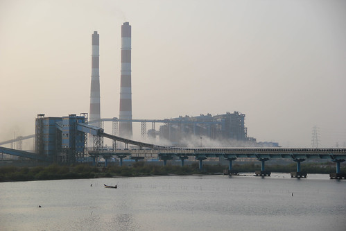
The lagoon is precariously perched on the east coast. While the Ennore thermal power plant and the Kamarajar port lie on the southern extensions of the lagoon on the Tamil Nadu side, the Krishnapatnam port and the proposed Durgarajapatnam port lie perilously close to the lagoon in Andhra Pradesh. The Indian Space Research Organisation’s (ISRO) Sriharikota High Altitude Range is located in one of the barrier islands between the Pulicat lake and the Bay of Bengal.
Wetlands are enveloped by the Ministry of Environment, Forests and Climate Change (MoEFCC)-mandated “eco-sensitive zones” (ESZ) designed to act as absorbers of shocks induced by infrastructure development around ecologically-sensitive, protected areas. While the ESZ of the Pulicat lake was originally set at 10 km by the Andhra Pradesh Forest Department, it has since been reduced to 2 km. Conservationists argue that the reduction in the buffer zone is completely uncalled for and an open invitation to ecological disaster in the area.
 The entire Pulicat system, along with the Buckingham canal and the Ennore creek, has been designated as ecologically-sensitive areas and is placed under the CRZ-1 category of coastal land classification under the MoEFCC’s Coastal Regulation Zone notification. Setting up of new industries and expansion of existing ones are not allowed in this zone. Regardless of it, the Kamarajar port has drawn up expansion plans, nearly tripling its cargo handling capacity from 30 million tonnes to 100 million tonnes. The thermal power plants and the port in Ennore draw water from the Ennore creek, a part of the Pulicat lagoon, for regular operation and maintenance. The thermal plants also brazenly discard hot water into the creek, harming the fish and affecting the local livelihoods. Xavier Benedict, who has been working to restore the natural and built heritage of Pulicat to its original glory through the AARDE Foundation, estimates that over 46,000 acres of the lagoon has been reclaimed over the past few decades.
Another worrying development is the large number of aquaculture farms dotting the periphery of the lagoon. The farms release untreated wastewater right into the lagoon as well as the Buckingham canal, altering the turbidity and composition of the water. “Aquaculture farms use antibiotics to produce shrimp which are indiscriminately released into the estuary,” adds marine biologist Rahul Muralidharan.
Threatened ecosystems; imperiled livelihoods
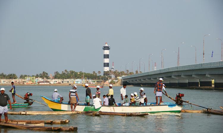
The Pulicat lake is among the few places in south India where the Padu system of fishing is still practised. The Padu system is a unique system of estuarine resource management where the lagoon is divided into grids and fishermen are granted access to fish on a rotational basis. Only male members of the traditional Pattinaver fishing community from four traditional fishing hamlets in the area are allocated fishing grounds under the Padu system. Though the practice is highly caste-specific, the Padu system is an outstanding example of regulating the use of and managing the coastal commons; regulations which ensure that members have equitable access to fishing grounds while nurturing a sense of collective social responsibility.
But Suman, a fisherman from Pazhaverkadu’s Lighthouse Kuppam is a concerned man. Though members of his village don’t participate in the Padu, the deterioration of the lagoon close by is hard to miss. Increasing bald spots across the lake have made many fishermen in Pulicat uneasy, especially in the 30-odd fishing hamlets partially or entirely dependent on the lagoon for their daily bread. Despite motor boats making it possible for fishermen to access a greater area compared to before, dwindling breeding grounds and diminishing catch are making them nervous.
The depth varies across the lagoon but there has been a noticeable reduction in the average depth of the system--from 1.5 metres in the early 20th century to less than a metre in many parts. The Arani and the Kalangi rivers also bring in a considerable amount of fertiliser residue as runoff from the fields upstream, polluting the lagoon further. And, it is no surprise that resources tend to disappear with the water.
“Decreasing depth in many parts, especially near the mouth, has severely affected the water exchange between the sea and the lagoon. With the lake shallow in most places, fish and prawn are becoming hard to find, not to mention, the difficulty of boatmen to manoeuvre their craft. The lagoon is so shallow that kattumarams (catamarans) graze the bottom in many parts,” Suman mentions.
 When the catch drops, so does the income. The portion near the lagoon’s mouth is the most prized spot as prawns move from and towards the sea at regular intervals which makes it the maximum profit grid. Apart from the mouth, which is the richest in terms of resources, boats casting their nets in other parts return home half full. Fishermen around the lagoon earn somewhere around Rs 1000 - Rs 1500 a day for those using fibre boats while men on kattumarams earn as low as Rs 300 to Rs 500.
Where have all the fish gone?
The integrity of the lagoon gets compromised if there is an excess of either fresh or seawater; the delicate ecosystem thrives on the perfect balance of brackishness where the life forms flourish.
Retired professor of geology R. Jagadiswara Rao blames it on the sandy sediments brought down by the rivers upstream. “Due to the vigorous movement of northerly longshore currents carrying heavy sandy sediment load discharged by rivers, long sandy shoals are deposited under water with sandy pits above the water closing the mouths of rivers and lagoons along the coast of the Bay of Bengal. Evaporation of stagnant lake waters makes them hypersaline with salinity becoming almost three times that of seawater. This is the single largest factor responsible for the substantial reduction in the lagoon's aquatic population,” he notes.
Rahul Muralidharan blames part of the disruption on the massive dredging carried out by the port authorities. “Dredging disrupts water current movement and increases sedimentation. As for portions around the Ennore creek, the ash and hot water released from the thermal power plants massively deplete the oxygen in the estuary, resulting in the decline in fish catch. Sand mining upstream is also a huge cause for concern.”
One of the most plausible explanations for the relative dryness in the northern portions of the lagoon in Andhra Pradesh is the shifting course of the Swarnamukhi river. Earlier, the Swarnamukhi which rises near the Chandragiri hills in Andhra Pradesh emptied into the Pulicat lake, and from there into the Bay of Bengal. The river’s course has since shifted; it now joins the ocean directly, leaving the northern part of the Pulicat lake dry. Only when the Arani and the Kalangi rivers get flooded do the flood waters reach the north Pulicat lake for want of an exit near the lagoon’s mouth.
Preserving Pulicat for posterity
To keep the lagoon’s ecosystem from cracking, care should be taken to not pressurise it over and beyond its acceptable threshold. Rivers should be allowed to flow freely without the menace of sand mining choking them at every turn. Professor Rao insists that the Coastal Aquaculture Authority must lay down strict guidelines to ensure that aquaculture farms release wastewater into the lagoon only after proper treatment to save the lagoon’s natural ecology from further degradation. Reclamation and infrastructure expansion--both public and private--should be strictly disallowed to preserve whatever is left of the lagoon.
To ensure this, Xavier has mooted the creation of a strong Pulicat Conservation and Development Authority along the lines of Odisha’s Chilika Development Authority to keep the lagoon in shape. Despite the officials at the Nellore and Tiruvallur collectorates having been briefed repeatedly in the past, the proposal continues to remain a mere idea with no concrete action taken till date.
Xavier believes that the health of the Chennai city’s water resources is inextricably linked to the Pulicat’s wellness. The brackish water body’s wellbeing is critical in keeping seawater intrusion at bay and sustaining underground aquifer systems. “People of Chennai need to wake up to the reality and take note of what’s happening in Pulicat; if not for the lagoon or its fishermen, at least for their own future water needs.”
References
1. Need of coastal resource management in Pulicat Lake–challenges ahead; N. Thirunavukkarasu, S. Gokulakrishnan, P. V. R. Premjothi and R. Moses Inbaraj; Indian Journal of Science and Technology (2011)