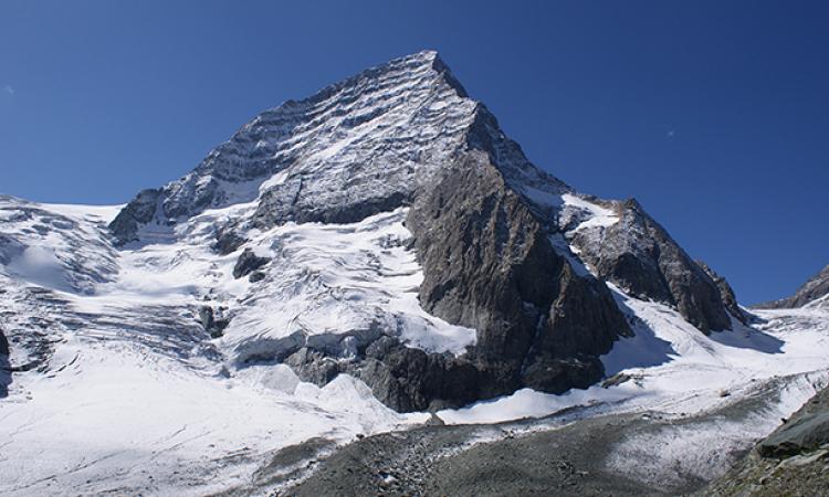
Kashmir’s glaciers are melting at frightening rates. Kolahoi glacier, the largest glacier in Kashmir Himalayas, has lost 23 percent area since 1962 and has fragmented into smaller parts!
Glaciers, frozen rivers of ice
The slow-moving frozen rivers of ice, the glaciers of the Himalayas, cater to the drinking water and agricultural needs of large sections of the population in the Indo-Gangetic plains. Glaciers are formed due to the accumulation of snow over thousands of years. The top layers of snow exert pressure on the lower layers transforming them into ice and this pressure combined with the force of gravity makes the glaciers move.
Described as ‘nature’s bulldozers, these solid rivers melt gradually with rise in temperatures and pick up vegetation and silt that comes in their way while flowing creating snow bridges, gullies, glacial lakes, glacial troughs, icefalls, valleys, crevasses and moraines and cause major changes in the topography as they descend forming rivers rich in sediments.
Glaciers, melting at fast rates in Kashmir
Kolahoi glacier is Kashmir’s biggest glacier and is the main source of water for the river Jhelum, which serves as a blessing for the fertile Kashmir valley. It is named after the Kolahoi peak – ‘Goddess of Light’ and forms the West Lidder river upstream of Pahalgam and the East Lidder near Amarnath. Both the rivers join together to form the Jhelum river near Anantnag. Kolahoi’s meltwater renders the Kashmir Valley extremely fertile with cultivation of cereal crops, dry fruits, saffron, and apples.
A study titled 'Linking the recent glacier retreat and depleting streamflow patterns with land system changes in Kashmir Himalaya, India' published in the journal Water by authors Irfan Rashid, Ulfat Majeed, Sheikh Aneaus and Mauri Pelto that assesses the changes in the Kolahoi Glacier between1962 and 2018, finds that the glacier is receding at a very fast pace.
It has lost almost 23 percent of its area since 1962 and has fragmented into smaller parts.
The glacial snout (end of the glacier) has been melting and retreating fast and glacier has been in an imbalanced state between 1962 and 2018 with melting rates being much higher than the accumulation rates.
This excessive melting of the Kolahoi glacier has been found to have strongly impacted the streamflows of the two largest tributaries, Lidder and Sindh, draining into the Jhelum. The consistently depleting streamflows have led to major land system changes in the downstream areas of the Lidder watershed where cultivation of irrigation intensive rice shows persistent signs of decline, whereas areas under orchards and built-up areas are increasing at unprecedented rates.
The study argues that while climatic change-induced streamflow depletion is possibly one of the causes of land system changes in the Lidder watershed, the economic considerations perhaps play a much bigger role in forcing the massive unplanned land system changes in the watershed. However, the depleting streamflows in the Kashmir region can greatly affect water security in the region and have a major influence on agriculture, hydropower and domestic water use, given the changing climate prevalent over the region.
Factors influencing glacial melt in the Kashmir Himalayas
Another study titled 'Satellite-observed glacier recession in the Kashmir Himalaya, India, from 1980 to 2018' published in the journal Environmental Monitoring and Assessment and Springer Nature by authors Shakil Ahmad Romshoo, Midhat Fayaz, Gowhar Meraj and I.M. Bahuguna that looks at the state of glaciers in the Kashmir valley and the impact of topography, morphology and climate on the state of glaciers, has mapped 147 glaciers from 1980 to 2018 in the Kashmir Himalayan region.
The study finds that the glaciers have reduced by 28.82 percent from 1980 to 2018 and the glacier loss in the region is much higher as compared to other Himalayan regions. The glaciers show increasing fragmentation or splitting up due to melting leading to an increase in number of glaciers from 1980 to 2018.
The study also finds that out of the 24 watersheds of the Jhelum basin, only four watersheds, viz., Lidder, Sind, Vishav and Doodhganga, still have few remnant glaciers. The highest glacier recession is observed in the Sind watershed.
Smaller glaciers show enhanced retreat as compared to larger glaciers due to their higher sensitivity to climate change because of their lower elevation and smaller accumulation area. The glaciers situated between the altitudes of 4200 and 4400 m have receded more than those situated at altitudes higher than 4800 m. Glaciers with steep slopes show lower recession compared to the glaciers with gentle slope. This is because glaciers having higher mean slope lead a relatively swift transfer of the glacier mass turnover from the accumulation area.
The south facing glaciers show higher recession compared with the north-facing glaciers as the south facing glaciers are exposed to high intensity and longer duration of the solar radiation. The period between 1980 and 1997 shows increase in streamflow while in the period after 1997, there is a significant decrease in streamflow. This has to do with enhanced melting of glaciers, which can lead to an increase in the streamflow for some period of time followed by a decline with the reducing ice mass in the later phases according to the study.
While the negative glacier mass balance threatens to drive glacier recession and decline in glacier runoff leading to decreased streamflows, urgent efforts need to be undertaken to devise strategies to cope with glacial recession and the impending water scarcity that can spell doom for the economy of the state, warn the studies.