Population increase has placed ever-increasing demands on the available groundwater resources, particularly for intensive agricultural activities. In India, groundwater is the backbone of agriculture and drinking purposes.
In the present study, an assessment of groundwater reserves was carried out in the Udaipur district, Aravalli range. It evaluated the current and projected groundwater reserves in the Udaipur region, and assessed its use for human consumption using chemical assessment. Udaipur is in Rajasthan’s agro-climatic zone IV-A and has a tropical, semi-arid, and hot environment. As it is arid, there is a huge demand for groundwater in this region.
The Precambrian-age Aravalli range circumscribes the entire district. The overall physiographic gradient is towards the south and south-east of the Udaipur district. Rocky hills mainly cover the most north-west to central portion of the district belonging to Aravalli range, with elevation ranging from 1313 m to 155 m above mean sea level (AMSL), and are considered to be good runoff zones.
There are various methodologies involved in evaluating groundwater reserves. GRACE data was mainly used for this purpose; however, due to issues of local scale uncertainties in the estimations, various authors have preferred water-balance equation-based approaches.
The water equation is based on the assessment of groundwater hydrology equations, and involves the assessment of the topography of the area, geomorphological conditions, climate variations, rainfall distributions, drainage characteristics, and hydrogeological characteristics.
The complete method involves assessing the geological formation of the area, the type of the aquifers with its hydraulic parameters, water levels, water-level fluctuation, water-level trends, groundwater flow direction, and all major chemical ingredient distribution and its concentration in groundwater.
Together, all this information is essential for assessing the availability of the groundwater and its usage characteristics. Overall, an integrated methodology involving the hydrological, hydrogeological, and hydrochemical characterization of the Udaipur region was adopted to evaluate groundwater reserves and assess their fitness for human consumptive use.
Using water-balance equations and statistical analysis in a spatial modeling framework, the study assessed the groundwater reserves of Udaipur, Rajasthan.

Conclusion
The main rivers in the studied area are the Sabarmati, Banas, Mahe, and Luni, which are the principal rivers carrying rainfall-runoff water. These rivers are seasonal rivers, with dendritic to sub-dendritic drainage conditions with 5–6 stream order that flow from central to south and south-east, north and north-west to east, and north-central to west of the district.
Geomorphologically, the area can be sub-divided into hills (structural/linear/denudational), denudational origin (pediment/buried pediment), and fluvial origin (valley fill). The area is climatically subtropical and subhumid, with semi-arid conditions. The average annual rainfall is 627.77 mm. The peak daily rain is 299 mm. The yearly average rainfall events were 30 days from 1957 to 2020. This reveals that there are chances to receive surplus rainfall year once following five consecutive rainfall deficit years.
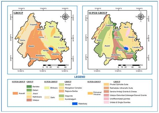
As per hydrogeological studies, the area belongs to the Aravalli, Bhilwara, and Delhi supergroup formations, consisting of quartzite, phyllite, gneisses, schist, banded gneissic complex, carbonate rocks, and dolomitic marbles. The principal aquifer in the studied area is quartzite, phyllite, gneisses, schist, and dolomitic marble, which are under unconfined to semi-confined. The availability and movement of groundwater creates pore spaces between grains, fractures, and bedding plains in the geological formation.
The combined hydraulic parameters of all aquifers are transmissivity (15.63 m2/day), specific yield (1.5%), and hydraulic gradient (1/130). The average water levels for pre- and post-monsoon are less than 25 m below ground level (BGL). The general groundwater flow direction is towards the south-east of the district, and the fluctuation in water level is around 3 m.
The average yield from all aquifers is 47 m3/day. As per hydrochemical studies, all primary chemical ingredients, such as pH, electric conductivity (EC), chloride (Cl), carbonate (CO3), nitrate (NO3), sulfate (SO4), phosphate (PO4), calcium (Ca), total hardness (TH), magnesium (Mg), sodium (Na), fluoride (F), potassium (K), iron (Fe), silicon dioxide (SiO2), total alkalinity and total dissolved solids (TDS) are in under permissible limits as per drinking water norms of ISO 10500–2015. Similarly, uranium (U) is also under prescribed norms as per the WHO.
This reveals that excess rainfall years have water quality under the permissible limit, and with deficient rainfall events, groundwater quality is slightly bad. The dynamic reserves of the area are 637.42 mcm/annum, and the total groundwater draft is 639.67 mcm/annum.
Hence, with deficit reserves of 2.25 mcm/annum on average rainfall of 627 mm, the state of groundwater development is 100.67%, and categorized as over-exploited. However, as per the relationship between reserves and rainfall events, surplus reserves are available if rainfall is at or above 700 mm.
Meanwhile, enough static reserves are available in the studied area to sustain the drought period. For the long-term sustainability of groundwater use, the control of groundwater abstraction and optimization of its uses by replacing existing irrigation practices with sprinkler-drip irrigation and achieving more crop per drop, adopting recycling and reuse of water through sewage treatment plant at the municipal/panchayat level, is the most pressing current need.
Moreover, it is also necessary to create maximum groundwater recharge structures as feasible and interlinking rivers for diverting floodwater to different places where groundwater is not available, or unable to sustain long-term use.
The study can be accessed here